The Whale’s Gift – Kayaking with the Orcas

Some call them blackfish or killer whales. Old salts still refer to them as grampus.

They are playful, highly vocal and, for 10-ton carnivores, are rarely aggresive. I heard the orca long before seeing them. On the flat waters of British Columbia, sound skims along like a stone. You can hear a blow miles away. In late August, salmon are in town and have set the upper echelons of the food chain in motion. Orca eat salmon, and the Johnstone Strait is a 24-hour cafe. For those interested in whales, this is the place to be. Some call them blackfish or killer whales. Old salts still refer to them as grampus. Orcinus orca is a highly social mammal that cares for young and old, staying together in the same pod for life. They are playful, highly vocal and, for 10-ton carnivores, are rarely aggressive.

Until the early 1980s, they were routinely shot at by fishermen or captured to serve life sentences in theme parks. Fortunately, the powers that be finally recognized them to be a highly evolved species, and today they are protected.
In captivity, they might live 20 years. Here in the wild, they can reach 80.

I had paddled the Strait for four days and had seen them far off each day. They are known to approach kayaks and had done so to me in the past, but it had been years since one was really close.

On my first kayak trip, I had been no more than a mile from this very spot when a pod of three transients came at me like a black-and-white freight train. They must have been doing 20 knots when I first spotted them about a mile away, and in the time it took to pull out a camera, they were almost in my face. The two females broke toward shore and avoided me entirely, but the bull came straight on. His dorsal looked about 10 feet tall that morning, and when he surfaced in front of my boat, his mouth was wide open and all I saw were tongue and teeth. I squeezed the shutter and got a shot of him but have no memory of doing so. Taking the photo was an instinctual reaction. That first encounter was so frightening, it still comes back to me in small flashes.

I was so intrigued by this monster that could easily have killed me, yet only gave me a curious once-over. The more I learned about orca, the more I had to know.

I have found these whales to be at least as intelligent as dogs, if not more so. They have a highly developed language, care for their young and old, mourn their dead and coordinate their hunts in a manner that implies a rather complex thought process.

Orca live in a society. The alpha female rules the pod and the alpha bull protects it. They leave the pod to mate but return when finished and spend their entire life together. These mammals are very high on the food chain and not because of brute force. They think! And that makes them fascinating.

I have never heard or read of an attack on humans or kayaks, even though transients have been known to come on shore to take a mammal for a meal. Aside from the initial shock of that first encounter, I have never felt threatened or endangered at all in their presence.

A Silent Witness

Four days in a kayak is a long time when you are over six feet tall. I was stretching out a cramp in my leg and taking a drink of water when I heard the familiar “whoosh.” A large black dorsal was coming right at me from three o’clock, about 500 yards out.

I kicked my rudder hard right, dropped the water bottle and quickly reached for the camera. Then I heard a second “whoosh,” and a third. Suddenly, whales were blowing all around me. They seemed to be converging on my boat, and for a split second I experienced that phenomenon known to kayakers as terrifying euphoria. I had waited a long time to see them so close but never expected to have dozens coming on like waterborne trucks.

The beaches of B.C. are mostly small, loose rocks. I happened to be opposite a rare cliff wall rising about 15 feet high. It ran for about 200 yards. Dozens of orca were converging on this wall, and I was in their path. They were driving salmon ahead of them into the wall. The salmon, in their panic to escape, were ramming headfirst into the rock, knocking themselves senseless. The orca zipped left and right, picking off the dazed salmon. Dorsals sliced through the water like so many black knives. Many came close enough to touch, but I was not about to stick out a hand while these carnivores were feeding. Logic does not always enter the brain during moments of high adrenaline rush.

I took several photos and tried not to move. Once the initial wave of attackers passed me, I realized I was privy to a natural phenomenon very few would ever experience. I sat there watching as a great struggle of life and death played out before me.

Salmon broke the water in all directions only to be taken in mid-flight. I saw several fish grabbed midair but was not quick enough to capture any of it on film. In fact, at this point, I was not even trying. I was simply being in the moment, totally in awe of what was unfolding before me. This went on for the better part of an hour.

As the frenzy began to subside, I watched four orca line up parallel to the wall and turn their flukes toward it.They commenced to slap the water with their tails, making large waves that crashed against the rock. They were using the water to dislodge the remaining salmon hidden in the cracks. As the final stragglers rushed from their hiding places, small dark flashes jumped to take whatever fish the initial assault had missed.

These were a pod of Dall’s porpoise, following the orca and cleaning up the stragglers. Porpoise often swim with orca, and there were plenty of fish to go around. Spouts of water were kicking up everywhere as the hapless fish swam for their lives.

The Dall’s were ballerinas, arcing out of the water, taking salmon in their mouths and diving back in one smooth motion. The porpoise formed a ring, keeping a respectful distance from their larger cousins who were in command, and allowed no victim to escape.

By now the entire event had taken on the aura of a grand play, and I was in the center of it all. I tried to pick out the biggest bull to see how he conducted himself during the scene. There were two or three around, but they just didn’t seem to be in charge. Somewhere close by, out of sight, was the alpha bull, silently watching.

I turned my boat slowly, trying not to disturb the water any more than necessary. I simply did not want to draw any attention to myself at this time. Then I saw him. He was about a half mile out and had not been part of the hunt at all.

He calmly swam back and forth, watching over things, making sure his cows and yearlings executed the hunt properly while he kept his distance. He was either already well fed or so into his role as protector that he let all those tasty morsels pass.

He was perfectly aware of my presence even though I hadn’t seen him until the hunt was almost over. His toleration of my being between him and the pod was proof that he considered me no threat. He was broadside to me with his head slightly elevated—enough for his small black eye to make contact. I felt that he knew what I was thinking at that moment, and we understood each other. I could watch as long as I didn’t interfere with the natural order of things. I had in effect been allowed to witness a highly secret ceremony, and the leader was telling me it was time to move on.

I began to paddle slowly, away from the alpha bull. Females and yearlings passed by me covering me with their blow. The pod was reforming around the bull. As quickly as it began, the hunt was over.

I counted 18 dorsals logging on the surface. I guessed they were just sitting there while heads were being counted to make sure no one was left behind. Suddenly the large female brought her flukes up and smacked them down. With that, the pod turned and headed north. When they surfaced, a few minutes later, they were far ahead of me.

I sat quietly for a few minutes, trying to absorb what had just happened. They were perfectly aware of my presence and tolerated it even though they were engaged in the deadliest activity of all, the hunt. I had been given an incomparable gift.

Since that day, I have often thought of what it might be like to one day actually communicate with these creatures. Then it finally hit me:They had communicated with me.

The entire hunt had been a communication by executing it with me in the center. They allowed me to see an inner part of their daily life that maybe only a handful of people will ever be able to witness. When an outsider is allowed into a closed society, it is the highest form of flattery. When it happens between species, it is a cosmic experience. I can only hope one day to truly understand these creatures that not only share our planet but also allow me to peacefully enter their domain.

The Few, the Proud and the Wet: Alaska’s Kayak Rangers

“Maybe this isn’t such a good idea,” I thought nervously as I wedged my paddle between two ottoman–sized icebergs. They were translucent–blue and among the smallest bergs jammed against my kayak–the largest was toward the bow and was more sofa-sized, to complete the living-room set.

Ice and fiberglass scraped together as I drove my paddle between the bergs and rocked my boat from side to side, loosening the ice at my bow. Ahead, dense ice concealed the water for a half-mile, and behind me, more ice had engulfed an opening I’d used only 10 minutes earlier. But that wasn’t my main concern; I’d pushed through dense ice before.

The big deal was the 200-foot-tall glacier about a quarter mile to my right–an uneven wall of blue and white ice about a mile long. For about a minute, ice had been falling from both sides of one of its giant pillars, smacking the water with reports like gunfire. The pillar–weighing thousands of tons–leaned precariously over the water.

“It’s not so dense about a hundred yards to your left–if you can get there,” radioed my co-worker Malinda Lueck. She was a half-mile away at the edge of a cliff 350 feet above the water. I could barely see her small figure against a fjord wall that rose thousands of feet into soggy clouds.

Just then, I heard a sharp crack. Turning quickly toward the glacier, I saw the skyscraper-sized pillar topple into the sea, sending an explosion of water and ice 150 feet into the air. The roar was terrifying as icebergs and 15-foot waves crashed against the granite shore bordering the glacier. Seconds later, another top-to-bottom section collapsed, echoing like a bomb blast against the surrounding mountains.

I could only watch as the waves approached, giant wrinkles in icy water, and soon I was rising and falling eight feet, with bergs grinding against my boat. The entire mile-long fjord was alive with rolling waves and the sound of crackling icebergs.

All in a Day’s Work

I am a kayak ranger. More accurately, I am a U.S. Forest Service wilderness ranger who happens to travel by sea kayak. I work in the Tongass National Forest, in one of southeast Alaska’s most spectacular wilderness areas, where high mountains covered in ice and snow rise directly from the sea, and three enormous glaciers flow to the ocean from the Canadian border. In southeast Alaska’s intimate blending of land and sea, I commonly encounter bears, mink, otter, humpbacks and orca while on the job.

But those are just perks of the workplace. The actual job is monitoring and protecting parts of the national forest that are designated wilderness: lands managed to retain their pristine condition. Along with four other rangers, I work full-time for six months each year. For most of the season, we patrol the wilderness by sea kayak for nine-day stints–enough time to travel parts of the area’s extensive shoreline and contact widely dispersed visitors. After nine days, we spend one day at the office writing reports and maintaining gear, then take four days off to recuperate before the next outing.

The Forest Service supports three kayak ranger crews in Alaska, with between two and six employees in each crew. They are the agency’s eyes and ears in Misty Fiords National Monument near Ketchikan, the Tracy Arm-Fords Terror Wilderness near Juneau, and the Nellie Juan-College Fjord Wilderness Study Area in Prince William Sound.

But before you request an application, you should know that parts of southeast Alaska receive more than 200 inches of rain annually and that the mean temperature in July is a hypothermia-inducing 56°F. The ocean temperature is somewhere in the low 40s and much colder near the glaciers. Then consider the steep and rocky shores–difficult places to land a fully loaded sea kayak, particularly in pouring rain–and the nearly impenetrable rain forest that borders the sea. The conditions are inhospitable, to say the least.

“I prepare for the season by whacking myself on the forehead with a two-by-four for 30 minutes each morning,” says Kevin Hood, a wild-haired Californian of 33 with a boyish enthusiasm for the outdoors. “Then,” he continued, “I take a freezing-cold shower with all my clothes on. Still, I never feel prepared.”

Photo:Forest Service ranger Ethan Kelley relaxes in light mist after a long day. Copyright Tim Lydon

Kayak rangers tend to move from one project to another. Like most wilderness rangers, our crew is involved in a variety of projects that help us manage and understand our area, provide education and assist with research.

For instance, Misty Fiords kayak rangers coordinate with botanists and biologists to survey flora and fauna and find rare species, creating a snapshot of southeast Alaska’s plant and wildlife communities. In Prince William Sound, kayak rangers have worked with the National Outdoor Leadership School (NOLS) and Alaska Pacific University to better understand the impact visitors have on popular campsites, which will guide management decisions.

So what was I doing stuck in the ice?

Prior to my run-in with the collapsing ice pillar, I had spent three days with two rangers camped a quarter-mile from a tidewater glacier in Tracy Arm, where we gathered data on harbor seals for the state wildlife agency and the University of Alaska Southeast. The data, including population counts and behavior trends, established baseline population estimates and may help explain the recent and sharp decline of seals in parts of Alaska.

As I’d learned long ago, nothing is as simple as it sounds with this job. First, just arriving at “seal camp” was challenging. After kayaking 30 miles of narrow fjord–usually two eight-hour days including breaking and setting camp each day–we had to push through thick ice to a rocky bluff a quarter-mile from the glacier. Between calvings, which sent big waves crashing against the bluff, we landed our boats and carried our gear 40 feet up slippery crags to a lumpy ledge barely suitable for camping.

Making camp–tying boats to boulders, setting tents, bear-proofing our food by hanging it from a cliff–consumed several hours, then we had to establish our research station, about 350 feet up the 5,000-foot mountain looming above camp.

In light rain, we carried dry bags full of tarps, binoculars, spotting scopes, tripods and data forms up a series of steep cliffs covered in dense brush. At one point, we crossed an avalanche deposition from the past winter, strewn with the torn fur and mashed bones of an unlucky goat that had perished in one of the slides.

At 350 feet, we reached an exposed ledge with a view straight down at the fjord, a mile-wide body of green ocean covered in icebergs ranging in size from hockey pucks to houses. In spring, more than a thousand seals congregate on the bergs to give birth to their pups. From 350 feet, they looked dark and sausage-shaped, but powerful binoculars provided close-up views without disturbing them.

In the following days, we settled into a routine: After breakfast on the bluffs by camp, we hiked to the research station by 8A.M. and began hours of seal counts and observations. Although a glacial wind blowing cold showers made huddling under a tarp uncomfortable, southeast Alaska’s dynamic nature provided endless entertainment–the glacier released enormous calvings, occasional avalanches roared down nearby mountains and bald eagles flew low sorties over the ice pack looking for afterbirth or stillborn seal pups. Between 10 A.M. and 2 P.M. each day, up to 20 tour and pleasure boats entered the icy bay for a view of the glacier.

Each afternoon, we hiked back to camp and cooked dinner close to the water. 
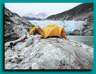
Steep cliffs prevented much hiking, so afterdinner, we watched the glacier, read or retreated to the tents if it rained.

Sleep was fitful at best. Darkness didn’t arrive until after 11 P.M., the glacier calved loudly all night, and the arrival of light at 3:00 in the morning aroused a chorus of songbirds right outside the tents.

Although the setting was spectacular, I was glad to leave seal camp on the fourth day for tamer surroundings and possibly some better sleep. Our other two rangers needed help removing an abandoned boat from a beach 30 miles away, so the next morning, I lowered my kayak down the bluffs, quickly loaded my gear, then launched on the frigid water.

Navigating Alaska’s Shores

The Forest Service uses kayaks for a couple of reasons. First, they facilitate access to Alaska’s relentlessly steep shores, enabling rangers to land in nooks too steep and narrow even for skiffs. And kayaks can be hauled out of the water at night, whereas skiffs have to be anchored, often an impossibility in fjords hundreds of feet deep and filled with drifting ice.

“Another advantage of working from kayaks is that we blend in with the wilderness we manage,” says Malinda, who has been with the program for three years. “We can visit campers and observe wildlife without disrupting them.”

While non-motorized travel is consistent with wilderness management objectives, it can be dangerous in Alaska’s harsh elements, and the Forest Service holds its employees to the highest safety standards. For instance, in Juneau each ranger is trained in a variety of self- and assisted-rescue techniques, first in pools, then in Alaska’s frigid waters. While on the job, they are required to carry a marine radio, paddle float, bilge pump, spare paddle, towing system and PFDs equipped with survival kits that include flares, strobes, space blankets, knives and magnesium strikers.

However, immersion suits are not required. Rangers go ashore frequently to inventory impacts, talk to campers and conduct other duties, and in the region’s constantly changing weather, such suits would be impractical. Instead, rangers always travel in pairs and are required to make radio contact with a dispatch office every 30 minutes while away from shore. Some programs even require carrying EPIRBs (emergency position-indicating radio beacons).

The downside to kayaks, of course, is that they are slow, especially against Alaska’s powerful tides, weather and ice. So occasionally we do use skiffs. But with tour boats frequently visiting the area, kayak rangers near Juneau and Ketchikan have established a barter system with the tour operators and share their knowledge and experience in exchange for quick transportation.

For instance, the morning I got stuck in the ice, I had an appointment with the MV Sea Lion, a 70-passenger vessel providing weeklong tours of southeast Alaska. As the waves from the calvings subsided, I found they had loosened the ice near my kayak,
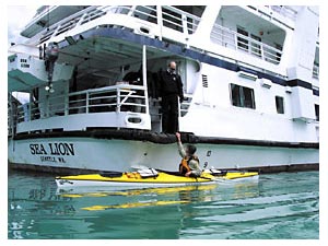
enabling me to paddle a mile through sporadic bergs to where the boat had stopped at the edge of another thick ice pack.
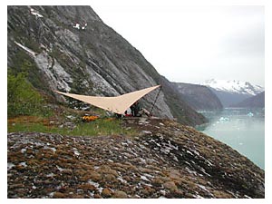
Forty passengers in raincoats braved the drizzle and cold breeze on the boat’s bow, cameras ready for the next calving. But as I approached, steering around icebergs many times my size, they turned their attention to me.

Photo: Phil Dewitt, a kayak ranger in Tracy Arm-Fords Terror Wilderness near Juneau, boards the tour boat Sea Lion. Onboard, Phil will share his knowledge of the area with visitors to southeast Alaska. Copyright Tim Lydon

“Aren’t you cold?” one of the passengers called from the top deck, 40 feet above.“Where did you come from?” yelled another.

We visit about 40 tour boats each summer, and the passengers usually react with the same surprise.

I paddled to the boat’s stern, where the crew lowered a ladder and helped me aboard. After helping pull my kayak onto the rear deck, they led me inside and offered me hot chocolate.

Before greeting the passengers, I hung my soaked rain gear near the ship’s galley and pulled my Forest Service shirt and hat from a dry bag I’d carried aboard. Although we usually wear sturdy rain gear, wool hats and synthetic layers while on the water, we carry clean uniform shirts for our more formal duties. In minutes, I had transformed from dripping kayaker to uniformed ranger.

A Captivated Audience

Education is an essential part of wilderness ranger projects and usually addresses minimizing physical and social impacts. However, the volume of tour boat passengers, Alaska’s spectacular scenery, and the fact that its two national forests are the nation’s largest provide kayak rangers a unique opportunity to educate on a broad range of topics.

Shortly after I boarded the Sea Lion, the vessel began its 30-mile sailing back to Stephens Passage, where it would leave our wilderness for its next destination. The trip would take three hours, and along the way, we would pass between high mountains and hanging glaciers.

For the first half-hour, passengers gathered in the lower lounge where I provided a talk about the Tongass, wilderness management and our specific projects. Afterward, I answered questions on a wide array of topics, including past and present cultures, natural history, logging and mining on the Tongass and specific wilderness issues.

These wide-ranging discussions provide rare communication between the Forest Service and boat-based visitors to the Tongass, making the program popular with both the public and the agency.

But the exchange also creates mutually beneficial dialogue between the Forest Service and tour operators. The topic of seals provides a good example: Ship naturalists receive current and accurate information about seals from rangers who help study them, and rangers have an opportunity to educate boat operators on low-impact ways of observing seals.

Between visiting boats, rangers also visit campers to share their Leave No Trace (LNT) expertise and information about the area. And in Whittier, Alaska, at the edge of Prince William Sound, rangers maintain an education yurt where kayakers and other boaters headed for the Nellie Juan-College Fjord area can find LNT, safety and logistical information. All three kayak ranger crews provide education in local communities by speaking to outdoor groups about LNT camping and wilderness management and helping train naturalists and kayak guides who bring visitors into the wilderness.

After three hours, the Sea Lion powered down to drop me off in a large bay surrounded by mature rain forest and glaciated peaks that mark the wilderness boundary. A few dozen passengers leaned over the rails as I descended the ladder and settled into my kayak. They waved and took pictures as I backed away, turned with a broad sweep stroke and paddled south.

Ten minutes later, I landed on a small island with lush rainforest growing right to its edges, the location of our primitive base camp. My co-workers Kevin and Jenny had arrived a few hours earlier, after paddling six miles from their last camp, and helped me carry my boat from the water.

“Dude!” exclaimed Kevin as we pulled lunches from our dry bags, “We were five feet from a humpback whale! It made a beeline toward us from a half-mile, then swam under our boats.”

“Wow,” I responded. “I’d say that’s the record, Kevin. Congratulations!”

It’s not uncommon to see humpbacks during our travels, and they occasionally get pretty close.

After lunch on the beach, we loaded rope, Pulaskis (axes with a hoe-like digging tool opposite the blade) and trash bags into our boats, then began a four-mile crossing to the mainland, where we would break apart an abandoned fiberglass skiff. Weather permitting, a barge would arrive the next day to haul the debris away.

Photo: Lonely Lookout: Shielded from the rain by a tarp, rangers spend a cool morning counting seals in one of southeast Alaska’s glacial fjords. copyright Tim Lydon

Like much of southeast Alaska’s Inside Passage, steep hills surround the bay, keeping its water flat and calm. Humpbacks sounded in the distance as we paddled, and the low clouds common to the region broke apart and clung to the mainland, creating fractured views of ocean, glaciers, forest and rocky peaks.

Ninety minutes later, we arrived on a small beach overhung by green forest and dragged our boats over wet sand dotted with mink and bear tracks. At the head of the beach, a winter storm had driven the abandoned boat halfway into the forest. Our job was to break it into manageable pieces with our Pulaskis, then drag it closer to the water where the barge could winch it aboard.

“We’re glorified janitors,” a former co-worker used to say of rangers.

While education and research are more stimulating, removing garbage is an equally important part of our job. But it’s not always fun. We’ve had to remove plenty of soiled toilet paper from stream sides to protect fresh water sources, and we commonly pack out food scraps so bears don’t become accustomed to human food. We also find clothing, broken equipment and food wrappers and break apart fire rings in an effort to maintain unspoiled beaches for wildlife and campers.

We spent two hours demolishing the boat and filling garbage bags with debris, then set up our camp just above the high tide line. After a big dinner of pasta with pesto, artichokes and Greek olives, we watched sea lions feed in a nearby kelp bed. As night slowly fell, wolves howled from the mountains behind our camp.

The next morning, Kevin and Jenny would wait for the barge, then paddle 10 miles to visit a group of kayakers on a commercial tour of the area. My next assignment was a four-mile paddle toward the bay at Stephens Passage, where I’d catch a ride back to Juneau on another tour boat. That night, I would be relieved to be back in town, where eating out, sleeping indoors and listening to music would be welcome novelties.

We spend five days in town after each trip. The first day is spent in the office writing reports, drying equipment and finalizing plans for the next trip, then we take a four-day weekend to enjoy civilization’s comforts. But as enjoyable as it is to sleep indoors and wear dry clothes, by the fifth day, we are usually itching to return to the field for the next trip. The work is always interesting and challenging, and the eagles, whales and tapping rain provide an unbeatable soundtrack to the workday.

Alaska’s Kayak Rangers: How to Apply

Applying for seasonal work with the Forest Service can be daunting at first, because of the lengthy application forms. However, determined applicants have an opportunity for rewarding jobs on some of the nation’s most spectacular public lands.

Each winter, often as early as January, the Forest Service begins recruiting for thousands of summer positions across the country, including wilderness rangers, trail laborers and biological assistants. To simplify the process, the agency has centralized advertisement of these positions through an Online application process. You can find available positions and a summary of the application process at the Forest Service web page: www.fs.fed.us

However, specific positions are sometimes not described in detail on the website. Applicants can learn more about specific jobs by contacting Forest Service district offices in areas where they are interested in working.

For instance, contacting the Juneau Ranger District (907-586-8800), the Ketchikan-Misty Fiords District (907-225-2148) or the Glacier Ranger District (907-783-3242) is a good way to learn about the availability of Alaskan kayak ranger positions. By January of each year, program managers usually have an idea of how many new employees are needed for the summer.

Of course, competition is high for kayak ranger positions. But it often surprises applicants that kayak mastery is not highest on the list of qualifications. While kayaking and other outdoor skills are important, a passion for designated wilderness, public-speaking skills, and the desire to educate wide-ranging wilderness visitors are essential. And flexibility is essential. Rangers work in primitive conditions and challenging weather and are often paired with only one other person; patience and strong interpersonal skills are among the strongest assets an applicant can offer. The Forest Service’s thorough kayak training can prepare less-experienced paddlers for the job, but the other skills are often talents no training can provide.

Pestilence in Paradise – Kayaking in South New Zealand

According to my first-aid manual, I could afford to lose about five liters of blood before my blood pressure bottomed out, the shutters came down and I lost consciousness. I’d already lost quite a bit, so I did a few hurried calculations: If a thousand sand-fly bites sucked up a milliliter of my blood, after five million sand-fly bites, I’d be history.

Only five million! Considering I had about ten thousand flying around me right at that moment, it occurred to me that not just my sanity, but my very life, was only as secure as my defenses against these nasty little blackflies. 
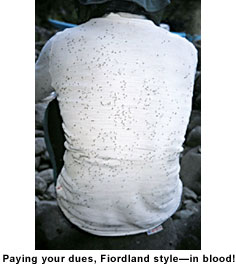
Not that I really felt endangered. With only my hands exposed, I was just impressed that Mother Nature could deliver shock and awe in such small packages. Impressed and annoyed, but mostly itchy. That’s the trouble with fine weather in Fiordland—the sand flies love it too. They especially love fine weather at dusk, in damp, cool tidal creek beds where there is no wind, and Lumaluma Creek, at the head of Fiordland’s Edwardson Sound, in late summer is just that—sand-fly paradise.

Like most rivers in the southwest corner of New Zealand’s South Island, Lumaluma Creek runs dark brown with tannins leached from the soil by the extravagant rainfall. Just beyond its banks, small flat areas are mostly waterlogged and dotted with stumpy crown ferns.

From our kayaks, it looked like you could pitch a tent anywhere, but closer inspection revealed the soggy truth. The lower reaches of the creek are tidal, and with the tide out, the small, rounded boulders along the shore reveal their cloak of slippery algae that confine your feet to the awkward clefts between them when carrying a laden kayak.

The late afternoon sun lit up the far hills through the canopy of beech trees, but our campsite had lost any sunlight it had been blessed with hours ago. Soon enough we had set up camp, and the place started to feel like home rather than a damp, sunless gully.

Unfortunately, it was just as good a home for clouds of tiny biting flies, and they welcomed us with the same enthusiasm that they have shown visitors for hundreds of years:

nor in short did we see any living thing on shore except birds and a small sand fly, but this annoy’d us more than perhaps fifty animals would, for no sooner did we set our feet on shore than we were covered with these flys, and their sting is as painful as that of a Musquitto, and made us scratch as if he had got the itch; indeed one of my legs became so much swell’d by this means that I was forced to apply a poultice to it, and was lame for two or three days.—Captain George Vancouver of HMS Chatham. Dusky Bay, 1791.

Mesh bug veils are de rigueur in Fiordland, and Brent, Peter and Ian had retreated behind theirs with desperate haste, while Anthony walked in brisk circles, applying insect repellent recklessly to his bare face and hands. His torment was only slightly reduced, as the writhing sand flies now stuck to his skin and were almost as annoying as when they were biting.

It was my turn to cook, and as I tended the small stove on the gravel riverbed among the densest aggregation of sand flies, I admitted aloud that this was a stupid place to camp. There was no dissent from my companions, but I think I detected a glare or two, for I had chosen the campsite on account of its proximity to a lake we wanted to visit the next day.

It’s hard to imagine any human activity more suited to satisfying the sand flies’ blood lust than camping. Tasks that require staying in one place, such as cooking, are particularly challenging.

An unattended bite escalates in seconds from a tiny speck of sensitivity impossible to ignore to a maddening itch way out of proportion to the insects’ size. They show little aversion to insect repellent, but they die in your dinner. They crawl through your eyebrows, bite your eyelids and get tangled in your eyelashes.

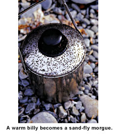
Cooking dinner is a trial, and eating it is equally challenging. While cooking, you can wear a mesh veil and constantly wave your exposed hands around. But eating necessitates removing your veil and exposing your face and neck to the onslaught.

You move about constantly—one hand holds your dinner while the other hand, clutching your spoon, is engaged in fending off hundreds of biting flies from your face and protecting the hand that holds your food.

Meals are consumed in seconds, but not before they are garnished with tiny black corpses like coarsely ground pepper. Sand flies, steamed to death, float in your coffee. Too numerous to remove, they add a curious texture—like unfiltered grounds, but softer. After dinner, hands return to pockets and the incessant buzz of the little flies continues about your face until nightfall. Finally, after dark, you get some peace. The forest seems to sigh with relief, and the noises of the night—a distant kiwi or the melancholy call of the native owl (morepork)—seem more peaceful than usual after a day’s battle with the flies.

At daybreak, what sounds like rain on the tent is just the noise of hundreds of sand flies bouncing between the tent and the tent fly. They have homed in on your body heat and exhaled carbon dioxide, and they are hungry.

The only respite from sand flies on a calm day is when you put to sea. The last thing you do before pushing off from shore is rip off your long overtrousers and leap frantically into the cockpit to seal your spray skirt in a frenzy of activity, trying to simultaneously shoo them from your bare legs. Then you paddle like hell, pursued by a cloud of sand flies. You have to keep them airborne until they run out of energy. Paddle, paddle, flail, brush, paddle, paddle.…

When you get bitten—on your leg—under your spray skirt—you can only make a quick contortion to kill the beast beneath, then off comes the spray skirt—scratch, scratch, flail (don’t lose the paddle!), fumble to re-seal it, and paddle, paddle furiously again. This goes on for about 15 minutes. Where’s the wind when you want it?

When the onslaught has finally subsided, and you no longer have flies buzzing about your ears and in front of your face, you can appreciate that Fiordland is not just a paradise for sand flies, but for sea kayakers too. That’s what keeps bringing my friends and me back to New Zealand’s southern fiords in spite of its endless hordes of insatiable sand flies.

Sand flies (Australosimulium spp.) have been tormenting people in Fiordland since its first inhabitants ventured there. As much as 800 years ago, feather cloaks and a layer of animal grease gave the early Maori some protection on their sealing forays into the region, but they never established a permanent presence there.

At the end of the 18th century, sealers slept in the same smoky caves that had been used by the Maori. Nineteenth-century mariners were among the first to record their impressions of Fiordland’s sand flies:

The hold full of flies and the whole of us much distressed by them, they fasten on us with such fury and fly into the nose mouth and ears; the itching they leave is positively enough to drive one mad.
—John Balleny, Captain of the Eliza Scott. Chalky Sound, 1839.

One hermit who lived for many years in Fiordland’s Milford Sound used to keep a 44-gallon drum by the front door of his hut. A small kerosene burner kept the drum as warm as a live body, and the outside of the drum was smeared with grease to trap the sand flies attracted to the warm surface.

Modern sand-fly defenses are both physical and chemical. Covering up is still the best method of protection. Uncovered skin can be liberally irrigated with DEET (diethyl toluamide). This stuff can melt plastic, so you don’t want any near your eyes. Sand flies know this, so they target your eyelids.

Contrary to common belief, DEET is not a repellent—it just inhibits biting. It works by blocking receptor sites in the sensory organs of biting insects so they cannot recognize you as a food source.

This, you understand, is no academic distinction. Even with liberal quantities of DEET on your hands, you’ll still have 30 or so insects crawling around on the back of each hand as you cook dinner.

They get stuck in a mire of DEET and sweat and crawl around among the hairs, dragging their sodden wings. You can squash them, but wiping the bodies away is not a good idea, as it thins the DEET film. So the carnage accumulates on the grisly battlefield of your skin.

Maori folklore has it that sand flies were created to ensure that the most beautiful of places, no matter how bountiful and benign, would still fall short of perfection. If that is so, then the creation of this annoying little biting blackfly is a triumph of economy. That such a small fly can have such a big impact on such a vast place is indeed a wonder.

On a calm day, if you come across a seal in a sheltered part of Fiordland, it’s unlikely to be reclining on the shore. Without a good breeze, sand flies dictate that Fiordland seals spend their daytime resting hours in the sea, slowly rotating at a pace that is just adequate to prevent sand flies biting.

This behavior can affect the seals’ energy budget and therefore their food requirements. The heat loss from spending more time in the water likely means that they have to eat more. Thus the sand flies have an impact on fish and squid populations far offshore. Little sods.

There is a theory that credits sand flies with making the kiwi and kakapo (a large endangered parrot) nocturnal, and after a few days paddling in Fiordland, anybody can see the sense in living in darkness.

Sand flies, mosquitoes and other annoying insects are a part of wilderness travel there’s no escaping. There is no bug-free option to be selected by ticking the box on a booking form. You pay your dues in blood when you visit Fiordland—it’s part of the deal. Just as you can’t experience a tropical rainforest without sitting out a wet-season thunderstorm, so it is with Fiord-land’s sand flies. They’re just as much part of our wilderness heritage as the pristine forest, the imposing mountains and the sheltered inlets. Our paddling paradise, too easily attained, would be devalued without them. And besides, as Maori legend suggests, paradise is intended only for the afterlife.

This was the argument I advanced to mitigate my earlier enthusiasm for our Lumaluma Creek campsite—an enthusiasm that had long since dissipated. About the only thing Brent, Peter, Ian and I agreed upon was that the sand flies were sure to protect our privacy, as most sensible people would stay well away from our campsite.

Sand flies are wilderness guardians of global significance. Captain Balleny thought so:

I do not think either natives or settlers could live any great time in this part from the myriads of poisonous flies…” Without them, who knows what sordid development might have grown from the timber- and gold-mining townships of Cromarty and Te Oneroa, which now lie decaying beneath a carpet of moss in Preservation Inlet (Fiordland’s southernmost inlet). When the gold ran out, nobody stayed behind to raise their children in these towns.

Australosimulium spp. may have played a major role in preserving the land that now has World Heritage Site status. Humankind may have laid claim to a benevolent custodianship of Fiordland, but in truth, we have merely surrendered the land to a very, very small predator with a thirst for our blood. Not bad for a little fly.

Cornwall Commitment

“Cornwall,” Marion said.

“Sure,” I said. “Sounds good.”

It is worth noting that at the time I was lying in the sun at the Renclusa alpine hut in the Spanish Pyrenees. I was deep in some endorphin-induced delirium on account of having survived the telemarking experience down Pico de Aneto, the highest summit in the Pyrenees.

It is also not beyond the realm of possibility that I was subject to some biochemical alteration in the brain owing to high altitude. Whatever the contributing factors, I maintain that I was not fully myself when I agreed to the sea-kayaking trip.

Foul-Weather Friend

Marion is about the finest friend you could hope for—an über-friend, even. There is nothing on this earth that she would not do for you. There is also nothing on this earth that she would not do, and she prefers to have company to do most things. Which is how I found myself lying in a tent somewhere near Land’s End, England, listening to the rain lashing down and cursing myself.

We were five: There was Marion, her partner Ken, Paul, Denise and me. We convened in the drizzle for a soggy breakfast, then made the first of what would be many phone calls that week to the British Coast Guard.

Stripped of meteorological euphemisms, the essence of the forecast was nasty. I have lived in Britain quite a long time now, and I feel qualified to state that, while the forecast is usually a variation on this theme, the reality is often worse.

The Coast Guard alleged that the rain would abate in the afternoon, and while this prediction stood a good chance of being typically inaccurate, our fearless leader nevertheless directed the movement of people, craft and sundry gear to a beach east of Penzance for an early afternoon launch.

The surfers were there too and looking enthusiastic, which I did not take to be a good sign. As Paul and I dragged our loaded kayaks down to the water’s edge, we passed a windsurfing board torn in two, with the sail still attached and no sign of a passenger.

We looked at one another. I tightened my life jacket, and made sure my whistle was firmly attached to it. Some good a whistle was going to be underwater.

“If you capsize while you’re launching…” Marion said to me. The way she’d stated it, as if it were a foregone conclusion, made me want to go back to the snack bar and call a taxi.

It’s worth pointing out that Marion was five months pregnant as we set out on this adventure.

At a stage when most women are already taking advantage of being in the family way to recline at every available opportunity, Marion, with her noticeable bulge, was securing my spray skirt and pushing me out into the choppy sea.

I made it through the breakers without capsizing. So did everyone else, although they seemed less amazed by their success. We rounded St. Michael’s Mount, which I know from photos is a breathtaking spectacle: a fairy-tale church on an island.

Despite our proximity to this much-photographed landmark, I didn’t see it because I didn’t dare lift my eyes from the immediate surroundings of my kayak.

By way of background, I should mention that I grew up on the Canadian prairie, that I saw Jaws before I first saw the ocean, and that anything ocean-related I have done in my life has been a fight against type.

While I have kayaked and canoed on rivers, lakes and calm stretches of the sea, I have a healthy respect for the sea that some might call terror.

Although I harbored no delusions that this adventure would find me out on the water, splashing and laughing, doing Eskimo rolls, having a big aquatic love-in like some beer commercial bon vivant, I still had an ambition.

I was there to conquer my fear of the sea. By the time we were on the water, however, I’d seen the folly of my ways and had made a Faustian pact that, should I live, I would swear off nautical activities ’til kingdom come.

I did not smile; I did not laugh. I scowled when my paddling partners shouted a tip or other information at me and refused to look at them. Occasionally I glanced at the horizon, but only to make sure the land was still there.

Obviously, I had not given due thought to this misadventure before signing up, but the most striking thing that hadn’t occurred to me was how difficult it would be to land anywhere along the coast of Cornwall. Before the trip, I had soothed myself with the thought that, if the going got rough and I felt uneasy, I could always just head for shore. Wrong.

It simply hadn’t dawned on me that I couldn’t land anywhere at any time by simply heading for the beach. Cornwall, I was coming to realize, has hardly any beaches, and half the beaches it has disappear at high tide.

The whole of western Cornwall appeared to be one big sea cliff, against which it was all too easy to imagine my kayak and skull crashing. In sea-kayaker parlance, such circumstances are known as “committing.” Committing what?

After what seemed like 300 miles (but which I later learned was eight), Marion shouted that we would land at a nearby beach. I snatched a quick glance at her.

She had her paddle out of the water, lying across her boat, and was looking at the laminated map she had strapped to her kayak. She lifted her head to smile widely at me.

That isn’t just sangfroid; it’s nothing short of reptilian. She came up right beside me and told me that the beach was called Praa Sands, and we would land there and either eat our lunch and carry on down the coast or stay there for the night.

In the end, it wasn’t our decision to make.

As we neared the coast, we could see the big waves breaking onto the broad, empty beach.

“If you capsize…” Marion said again. I didn’t want to prolong the agony. Ken had gone first, and I hadn’t watched to see where he wound up.

Denise had caught the wave before me, and as a huge wave hefted my kayak up to an impossibly high vantage point, I saw Denise below, in the water beside her capsized kayak.

The bow of my kayak was progressing toward Denise’s head at a terrific velocity, and I was powerless to slow down or alter my course, or do anything except plummet toward her head.

What happened I can’t say exactly, but I do know that I wound up underwater and quite instinctively pulled off my spray skirt, got out of my kayak and surfaced.

There were no bits of brain floating on the water. Instead, a frantic-looking but intact Denise was dog-paddling toward me. I felt like weeping with relief that I hadn’t killed her.

I pulled her to my capsized boat, put her hand on the bow toggle and told her to stay with the kayak. Then I swam out into the waves and gathered together the detritus: paddles, Denise’s boat, a cap, sunglasses, bandanna. I swam back to shore hauling these things, and together we pulled our waterlogged boats up onto the beach.

Everyone had capsized.

We phoned the Coast Guard to tell him of our heroic landing. I realize it’s delusional to speak of the Coast Guard as if he’s one guy—a bit like the Great and Powerful Oz, keeping a round-the-clock vigil.

Still, it’s a comforting fiction. In my mind, the Coast Guard looked a bit like Neptune dressed up as Captain Stubing from The Love Boat, skippering a giant white yacht with HM Coast Guard written on it in red letters.

The Coast Guard of reality had to look over his list twice before he figured out which party we were. “Oh, the kayakers,” he said. He told us the next day’s forecast was for Force 6 or 7 and occasionally Gale Force 8 winds.

I had no idea what Gale Force 8 meant, but if the wave scale was anything like the Richter scale, I’d decided I would remain at Praa Sands, sleep in a homemade hammock and drink out of coconut shells à la Gilligan for the rest of my days, rather than brave those freaking waves again. The sea was no friend of mine, and it was over between us.

I have no explanation for how it came to be that a day and a half later, after two nights at Praa Sands, I had this déjà vu experience of heading out into the churning sea in my ever-loving kayak.

My upper body was completely soaked within minutes. The swells were even higher than they had been previously. The sensation was something akin to watching your friends atop rapidly moving buildings. At one moment they’re towering above you, and the next moment, you’re the equivalent of four stories above them.

At times, you’re in a deep trough, unable to see anyone else, and it’s easy to gain the impression that you’re utterly alone.

I assumed my don’t-talk-to-me-except-in-an-emergency scowl and paddled determinedly along. Again, the continuous wall of sea cliff was to our left. We loomed as close as we dared to the two beaches we saw en route, only to discover that they were peopled by surfers, and an encore performance of the collective capsize-o-rama was guaranteed if we tried landing.

Marion shouted that there was a small harbor at a place called Mullion Cove, and if we made for it, we could land safely and perhaps even with grace. We had to get very close to it before the small opening in a sea wall revealed itself. In we went. Instant calm; profound relief. Better still, the place had a little café that served cream teas.

It was decided that we’d stay put for the rest of the day in view of the choppy seas and the difficulty of landing between Mullion Cove and Lizard Point. We would do the Lizard Point passage the following day, and with any luck the sea would calm down.

This expedition was not noted for its luck, nor the sea for its calmness, and my heart was heavy with trepidation as I slathered a scone with cream. Might as well enjoy myself, I thought. It could be my last scone for life. Considering that the swells had the entire distance between the east coast of Canada and Cornwall to work up a head of steam, it seemed improbable that they would calm down somehow.

Early the next morning found us schlepping back to Mullion Cove from our campground. According to Marion, we had to start off at 6:30 to hit Lizard Point at the right time, with respect to currents and tides.

When we got to the harbor, the sea was whipped up white and frothy, looking more forbidding than it had to date. The Coast Guard certainly had nothing good to say.

Denise and I convened an emergency meeting and decided that whatever the inconvenience or expense in terms of cash or dignity, we were willing to suffer same rather than go out there.

We presented our proposal as decorously as possible to meet the balance of the party farther along the route, but it wasn’t necessary. They had also decided it was too risky. Even Marion.

Marion and Ken brainstormed a complex arrangement that involved public transportation and a lot of time, but the upshot was that we were going to do a car portage to cheat Lizard Point and drive to Kennack Sands, which would hopefully be more sheltered and calm. I was ecstatic. Perhaps the sea would not have me after all.

True to prediction, the sea at Kennack Sands was millpond still. The only churning was the human activity on the busy beach, where even toddlers were venturing into the water with just limited supervision. I launched without incident or even fear, which made it a bit of an event.

We paddled along the coast, the topography of which had become much less dramatic: beaches all along and no sea cliffs. I could land anywhere. I could laugh and splash and make conversation. I could be a beer commercial bon vivant. This was the kind of committing I could get into.

It was nice. The sun shone, and we chatted as we paddled. Ken got out a fishing line and caught a few mackerel that he and Paul later cooked over a campfire on the beach.

After Lizard Point, the Coast Guard’s forecast never predicted winds of more than Force 4. We went up Helford Estuary and Frenchman’s Creek, of Daphne du Maurier fame, where smugglers and other lawless types once hid out. At high tide, we paddled all the way up the estuary to a pub at Gweek. It was all incredibly pleasant.

It was also a bit boring. Which goes some small way to explaining how the following exchange happened after we’d paddled back out the estuary and were spending our final night at a campground near Falmouth:

“What do you think of paddling around Corsica next?” Marion asked, sitting cross-legged beside the camp stove, with her tummy protruding into her lap.

“Sure,” I heard myself say. “I’ve never been to Corsica.”

I could put it down to sunstroke or water on the brain, or blame Marion for transforming me into an adrenaline junkie. But a girl doesn’t make an über-friend everyday, and one like Marion is probably more of a once-in-a-lifetime offer, however abridged that lifetime might turn out to be.

Mexican Therapy

It’s funny how things happen in slow motion once they become irreversible, like falling off your bike or knocking over a glass of red wine onto a white tablecloth.

This is especially so when the event that starts to unfold in painstaking detail is something that you know you’ll regret later—the result of some ill-considered act that will return to haunt you.

Like throwing my mobile phone across the office because it had just cut out in the same infuriating way that it had done ever since I bought it.

A mobile phone in flight is not especially graceful—just a piece of low-altitude space junk, really. My office is small too, so that it hardly completed a single spin before its flight was arrested by the arm of a chair.

The hard, unyielding, cold steel arm of a chair that’s as unaccommodating of flying mobile phones as my own temperament is of disobedient ones. Somehow during its flight, I’d had time to wonder if it would survive. I almost hoped that it would.

Almost. And then it became so many pieces that any hope I had imploded as the infernal thing did the opposite on that chair arm. For a moment, it continued its flight, but in different directions, and it bounced and scattered like the contents of a bag of peanuts dropped from a balcony.

Then life resumed its normal pace. As I gathered the shattered pieces from the carpet, I asked myself—did I just lose control, or was that a reasonable act of retribution? Either way, one thing was certain—it was time to go sea kayaking.

I sent an email telling my friends and associates that my mobile phone was no longer operational. Then I opened my drawer, took out a small folder, unfolded the airline ticket inside and glanced at the list of stops on my itinerary—Wellington, Auckland, Los Angeles, Loreto—and then the date. I had only four more days to go.

Six thousand miles, 11 hours’ flying time and four airline meals later, my companions, Brent and Paul, and I had crossed the Pacific Ocean and had reached our departure point for another kayak journey.

Arrival in the Mexican town of Loreto was sweet—but not for long. Having been groped by half a dozen airport security officers on the way to Mexico, it was a final insult to discover on arrival at our hotel that the security process had also relieved me of my camera and sunglasses.

Loreto is a very nice town, full of Mexican charm and friendly folk, but alas, it’s not a place where you can purchase a weatherproof 35-mm camera. My missing camera was the one I had always carried in my kayak, and now it was gone.

It was great to be there, but it would have been better to have my on-the-water camera too. That vacation feeling of leaving all my cares at home was eluding me. “Una mas margarita, por favor.”

A few hours later, we woke up in paradise. Just over the back wall of our hotel, across a narrow white strip of sand, the Sea of Cortez was smooth and the sun hung low over Isla Carmen, the light softened by the thinnest veil of high cirrus clouds.

A solitary dog sniffed its way along the tide line searching for morsels, while a crow loudly scoffed at the dog’s chances. A committee of pelicans stood about on a short rocky breakwater, as if waiting for the morning papers to be delivered. The palm trees had no reason to sway, and the smell of fresh coffee lured us to breakfast.

We examined our newly acquired maps, seeing for the first time some detail of the route we planned from Loreto to La Paz—a distance of about 200 miles. The outdoor dining area was attended to by Juan, a Mexican with a ready smile and a talent for making margaritas.

When we told Juan what we were planning, he looked at us as if we’d completely missed the point of visiting Baja. He explained that it would be much more fun to just hang out at the resort for a week rather than paddle all the way to La Paz.

John Steinbeck explored this region in 1940 and chronicled his adventures in The Log from the Sea of Cortez.

His was a trip to collect marine animals for classification against the backdrop of World War I and was an escape, in a sense, from a dark world-political climate into the bright sun of Baja California. Our own excursion was also something of an escape from the Southern Hemisphere winter and the complexities and pressures of our professional lives.

After a day in Loreto, we had gathered the food and other supplies we needed for our trip and had it packed in dry bags to load in the morning. That night, Brent assembled his new cooker, which, with its ability to burn white gasoline, propane, kerosene, petrol and just about any other fuel you can name, promised to be a remarkable device.

Reading the instructions, always a good last resort, revealed the fact that the cooker is supplied with three jets, each for different fuels. Somehow, Brent had managed to misplace two of the little jets, leaving us with—you guessed it, the wrong one for the only fuel we had. Luckily, the cooker still worked, although its performance was adequate rather than spectacular. At full throttle, the small blue flame purred rather than roaring reassuringly.

We pushed off from the beach in a fresh northeasterly wind and headed across to Isla Carmen in a moderate sea. We soon found our rhythm despite our kayaks’ being laden with containers full of fresh water.

As we made progress across the channel, waves slopped over our foredecks and spray skirts, washing leaves, sand and other terrestrial detritus away, leaving our decks shiny and wet. It was like a ritual cleansing, and I could sense a similar cleansing in my mind as we left urban life in our wake. I reveled in the prospect of a new voyage unfolding before me.

A few hours later, we made landfall on a small rocky beach backed by a dry creek (arroyo). As we ate lunch, a carpet of big isopods emerged from among the stones and moved across the beach like hundreds of huge cockroaches. Any movement from us and they instantly vanished into the spaces between the rocks.

Sally Lightfoots—large, agile, red rock crabs that I’d only seen previously on documentaries about the Galapagos Islands—inhabited the rocky beach and avoided us with a calculated nonchalance as we walked along the shore.

They countered any attempt to encroach on their personal space with equally determined avoidance. With excellent eyesight and an erect alertness, they convey an intelligence not usually associated with crustaceans.

Steinbeck described his efforts to capture some specimens—going to extraordinary lengths, even lying in ambush behind rocks while the crabs were approached by others from another direction—with a remarkable lack of success:

“Eventually we did catch a few Sallys, but we think they were the halt, the lame and the blind—the simpletons of their species. With the healthy Lightfoots, we stood no chance.”

As we made our way south, we were soon absorbed by the simplicity of the place: the vast sea and the vaulted blue sky overhead, three dimensional with its ever changing pattern of high clouds, and between them, a parched landscape of a thousand shades of earth.

Yet for all the stark inhospitality of the place, it positively pulsed with life. At sea, the drama of predator and prey played out before us.

Schools of mullet exploded from the water without warning as unseen predators tried their luck. We could hear the labored breathing of whales much of the time, and huge aggregations of krill that we could actually smell darkened the sea a short distance offshore.

Frigate birds, agile and athletic, were always on the lookout for morsels and would nonchalantly pluck them from the sea surface as they passed.

On land, the struggle seemed to be with the rugged, dry climate. The sparse vegetation of the Sonora Desert revealed the land’s stark form beneath, like a diaphanous garment.

Desert plants are ruthless in their defenses, and life seemed harsh compared to the prolific excesses of the sea. But at night, once the sun had relaxed its grip, the air filled with sounds of the desert.

Crickets chirped, and there was scuttling in the dry leaf litter at the base of cactuses. Coyotes yelped in the distance, accompanied offshore by the deeply resonant exhalations of passing whales.

Cactus spines littered the ground. One night, I stepped on a cactus spine that penetrated the sole of my footwear and didn’t stop until it hit my heel bone. The pain was excruciating, but when I extracted the spine, I was relieved to see it emerge intact.

There was no indication of where it had penetrated, and even a good application of iodine failed to reveal the broken skin. I limped around for a while, trying not to think of the consequences of an infection, but in the morning, it felt fine and, apart from a bruise, didn’t bother me again.

We concerned ourselves with nothing more than the tides, the rhythm of waves and the daily routine of camping and paddling. Each dawn was a drama of light that started with a deep crimson glow spreading across the eastern sky, gradually replaced with gold.

Then a tiny bright dot of yellow appeared on the horizon that grew in about four minutes into the sun’s bright disk, bringing with it the heat of a new day.

After a couple of days, my disappointment at losing my camera had subsided. Without it, I became an observer rather than a recorder. Weaned from the reflex action of trying to get a picture every time we saw something of note, I found a sense of freedom in savoring the sights, sounds and smells.

Near Punta Trabillas, we were lucky to witness the drama of hundreds of pelicans

feeding on bait fish that had taken refuge from the diving birds in shallow water. The shoal of bait fish was beneath us for nearly an hour as we headed south, in water little more than a meter deep.

The school parted as our shadows passed over it and re-formed as if it were a single moving, pulsating organism. Occasionally, the presence of a predatory fish would spread panic, and the entire school would flash silver in the sunlight.

Pelicans resting on a rocky headland are awkward in a self-conscious way and almost reluctant to move. But once in the air, they settle their heads back so their necks are hidden, and they’re transformed into graceful masters of flight with an uncanny ability to glide just over the surface of the water with no apparent effort.

When hunting, they fly higher and, in an instant, plummet into the water for their next meal with necks extended and wings folded back. The significance of the dive is not lost on the gulls, either, who zero in on any surfacing pelican in an attempt to rob it of its catch.

Before swallowing its catch, a pelican has to drain the water from its throat sac, which sometimes presents an opportunity for the gulls to snatch up a stray fish.

There were ospreys, too, which peered down from extravagant nests in cliffs. Hauling ashore under the cliffs meant sharing the beach with dozens of huge wasps—big, in-your-face insects with the slow, deliberate movements of creatures with nothing to fear.

On our last evening, Brent and I visited a fisherman in his shanty on the beach. We had seen him as we made landfall and wanted to make sure we could share his beach for the night.

For a few pesos, he happily sold us a couple of beautiful fish—a sierra and a mackerel. As he prepared them for us, he told us of the problems he was having with sea lions robbing his nets and tearing them to shreds.

Back at camp, we made a salsa with fresh chilies, tomato, onion and some herbs. After frying the fish in a little olive oil, we wrapped the whole lot up in burritos and ate them on the beach, sipping the last of our tequila as the light drained from the sky.

The warm wind that had pushed us along all day had died, and the low surf crashed lazily onto our little beach in the still evening air. The sky gradually filled with stars, and the bushes were alive with chirping crickets. Just then I realized that I had found what I had sought here.

We’d come a long way in the time allocated, but more important, the journey had allowed us to shed the chaotic load that so often accompanies our working lives. Away from project deadlines, help-desk calls and the constant interruptions of our daily routines, we had shouldered out the chaos by the rhythm of tides and waves.

Steinbeck experienced a similar thing here: “The matters of great importance we had left were not important. There must be an infective quality in these things. We had lost the virus, or it had been eaten by the antibodies of quiet. Our pace had slowed greatly; the hundred thousand small reactions of our daily world were reduced to very few.”

Even now, I occasionally think of that cactus spine in my foot. I like to imagine it was a kind of inoculación de Baja—a vaccination against the stress that, left untreated, can result in the sudden short flights of mobile phones.

Rescue in Alaska – A Rising Wind Overpowers two Visiting Kayakers

THE DECISION TO GO

I had been thinking about paddling in Alaska for a long time. Many kayakers I know have paddled there, most of them in organized groups, and almost all of them in Prince William Sound. My friend and fellow kayaker, Albert, instantly accepted the idea of paddling in Alaska, but proposed a different Alaskan destination, the Kenai Fjords.

We both are committed kayakers. I’d been kayaking for six years year-round, along the Mediterranean coasts of Tel Aviv and Herzlia. I made a few kayak trips in Greece, visited Wales during summer and winter for the intense BCU Five-star training, and joined the three-man Ireland expedition, paddling 400 miles clockwise from Dublin to Galway. I feel quite comfortable in tidal races and in surf zone and have a good roll.

Albert had been paddling for four years. He has never taken serious advanced kayak training; he can roll but his roll is weak. He has done a couple of kayak trips in Greece and paddled for two weeks in Alaska with a strong group, both in Prince William Sound and in the open sea.

Our plan was to explore the Kenai Fjords launching in Seward, rounding the Kenai Peninsula and taking out after roughly 300 miles at Homer.

FIRST EIGHT DAYS

On the bus from Anchorage to Seward, our driver updated us on the weather situation: “We’ve had a very dry summer this year, very unusual, but now, at last, we’re getting the first real rain.” We could see the dark clouds from the bus window.

At Seward it was already raining heavily and we were informed that the wind outside Resurrection Bay was southeast at 45 knots. Alan, the local kayaker who helped us with the kayaks, commented on that:

“You wouldn’t believe what beautiful weather we’ve had all this summer, but we always knew that when the storm would come, it would come big.”

We decided that even in this weather we could start our trip if we kept to the sheltered water inside the fjords and bays. We left on the next day, knowing that we would stay in Resurrection Bay, until the conditions improved.

We were paddling rented NDK Explorers, the same model that both of us own and paddle at home. Both of us carried NOAA nautical charts of the area on our kayak decks.

We each had a compass mounted on our kayak fore decks. Albert carried a simple waterproof Magellan GPS in his day hatch. He carried a backup GPS, this one a Garmin, packed below deck. I had an Icon waterproof marine radio, kept in a waterproof bag that was attached to my deck.

I also had a Macmurdo PLB (Personal Locator Beacon) with GPS in a pocket on the back of my PFD. In a dry bag deep in my day hatch, I had two aerial flash rockets.

While on the water we both wore drysuits with one layer of fleece and a hat. Each of us used a paddle leash and had a spare paddle on deck.

The constant rain stayed with us for the next eight days, usually accompanied by wind and fog.

We continued our trip, cautiously passing from one fjord to another, always having escape plans ready and usually using them. On one occasion we had high and rising choppy seas and strong wind just before the narrow McArthur passage, but we found shelter safely in Chance Cove that was one of a few escape places that we prepared for that day.

On another occasion we were surprised by the enormous strength of the tidal race at the entrance of the Northwestern Fjord—it was clearly impassable so we camped on the western side of the upper Harris Bay. It was the only place that day without big surf and suitable for landing. We didn’t have a day without a new challenge.

By July 29 we had covered 155 nautical miles and more than half of the distance to Homer.

On that day we camped at Berger Bay on Nuka Island. It was a beautiful gravel beach with a place for the tent and a natural place for our kitchen. We had a fresh salmon that I caught and it was our first camp almost without rain. What else does a kayaker need?

THE PLAN FOR THE DAY

We knew that Gore Point is often a difficult place. It has high cliffs, unpredictable currents and rocks all around. But Gore Point was not our main concern. We worried more about the day following our rounding of the point. On that day we would have to leave very early to catch the flood.

It was the only way to continue west from Gore Peninsula and cover the long distance to reach the first landing spot. To set ourselves up properly for the following day our objective was to pass Gore Point as quickly as possible and to camp at the first place that presented itself.

We knew of one potential campsite, Ranger Beach, located on the west side of the base of the Gore Peninsula. It is a sandy beach and the landing should not be a problem with the usual SW winds. Ranger Beach was located 15 miles from our camping site on Nuka Island.

At that point in the trip we were in good shape and could easily paddle at 4 knots, so the entire way with the favorable wind and current should take less than five hours. That was the good news. The bad news was that the last 11 miles, everything west of Tonsina Bay, offered absolutely no place to land.

It is all high cliffs and we knew very well from the previous days that even in a moderate swell we would do well to stay at least one mile away from the land. We hardly had any rain that evening and our weather forecast, for a change, was not bad.

The last forecast that we got by satellite-phone text message from our weather support man in Israel was for wind ESE at Beaufort Force 3 to 5, and waves at one to two meters coming from SSW.

The VHF reception was very bad at our campsite, but from what we were able to make out seemed to be a forecast that was no different from our satellite-phone forecast.

Before we retreated to our tent that night we watched the northern lights on the horizon. We felt encouraged by our prospects for the following day.

THE GORE POINT DAY

We left our camp on Nuka Island at 1 P.M. The sea was very quiet and there was almost no wind. It was foggy but not too bad; the visibility was about two miles.

We decided to go in the same manner as we did on the previous days—keeping within sight of land. It made navigation easy and we could quickly determine our location based on the shoreline shape and the mountain relief. We headed west and then southwest to Tonsina Bay.

Very soon after we left, we started to feel some wind. It was NNE at Beaufort Force 3 to 4. This direction was unusual and not the forecast. The wind was, however, ideal for us, and I had nothing to complain about having it help push us along.

In about one hour we could see Tonsina Bay on our right side. Our speed was very good, the weather was great and we continued south to Front Point.

On our way to Front Point the wind changed to northeast but still was at Beaufort Force 4. There were only the occasional whitecaps. The only thing that worried us was that the fog was becoming worse.

We could still see the land from about one mile’s distance, but it was behind a hardly transparent screen of fog. We worried that our view of the land could disappear in a few minutes. But the sea conditions were not bad at all at Front Point and we continued to Gore Bight.

The three miles from Front Point to Gore Bight took about one hour and within that span of time everything changed. The wind grew stronger with frightening persistence. In one hour the wind had changed from a friendly Force 4 to a challenging Force 7. The direction of the wind changed as well, shifting from northeast to east.

At 3:30 P.M. we were two miles northeast of Gore Point in a rapidly strengthening wind and in waves reaching eight feet and coming from all directions. We still could see some shape of the land to the north, but the fog obscured any hint of the Gore Peninsula. (The log kept by the captain aboard the nearby fishing vessel Vigilant noted “15:30 … Gore Point, Winds 45 miles per hour, Seas 10 Feet.”)

I had to brace constantly just to stay upright. Albert was much less experienced in a sea like this, and I knew his situation had to be much worse. We were pushed by the wind toward the most intimidating place on the whole Kenai Peninsula. The locals know it as the best location to find interesting debris that has been driven ashore by wind and waves.

It was absolutely clear to me that we were in serious trouble. I called out to Albert, “I think we should call for help.” He quickly agreed.

We brought our kayaks alongside one another. Albert held my cockpit with both hands and I took the VHF radio from my deck and attached it by the wrist strap to the clips in my PFD’s right pocket. Then I switched the VHF on, put it on Channel 16 and pressed the transmit button.

“MAYDAY, MAYDAY, MAYDAY. We are two kayakers two miles northeast of Gore Point. We are still in the kayaks but cannot paddle and we are drifting in the strong wind.”

I had very little hope that anyone would receive our message as we hadn’t seen any other boats since we left Aialik Bay five days ago. We hadn’t seen anyone onshore either.

To my surprise, the call was answered. The blowing wind and the fact that English is not one of my native languages didn’t help. I could understand only part of what came across the radio. I heard: “This is … Star, … specify your position.” I didn’t know who had responded to my call. I replied “Please wait.”

In the strong wind and high waves Albert and I concentrated on keeping the kayaks rafted together. I put the VHF into my pocket, then held Albert’s cockpit while he retrieved the GPS from his day hatch. We couldn’t make any mistakes.

He switched the GPS on and held my cockpit as the coordinates appeared on the GPS screen. I took the VHF out and relayed our coordinates using numbers as well as the words “degrees, minutes, seconds, north, west.” (It was explained to me later that I was expected to use only digits, everything else only made the reception more difficult.)

The VHF came back: “… sending the boat … will come in one hour and fifteen minutes. It is a big black boat; you will see it.” I was not so sure that we would see it in the fog. The hour we would have to wait seemed like a very long time, too long a time.

I looked at Albert: “Let’s activate the PLB.” Albert took the PLB out of the pocket on the back of my PFD, and opened the safety. “The lights are on,” said Albert.

We were so focused on operating our electronics that we didn’t look around even though we knew we were drifting. Albert glanced up, “Gadi, look!”

I looked and saw the landscape looming over the fog. The land wasn’t the coast we’d been seeing to the north. It was to the west. It was the Gore Peninsula. We were drifting very fast in a very bad direction. There was very little chance we would survive being washed ashore on the peninsula. The only solution was to paddle away very fast. We needed to move about one mile south, to avoid getting washed ashore.

I called on the VHF: “This is the two kayaks; we will try to paddle south and get around Gore Point.”

We started to paddle again, bearing ESE to make sure our real progress was to the south. Our effort was mostly against the wind now, and it helped our stability to have the waves coming over the bow. But the farther south we moved, the worse the sea conditions became. It wasn’t surprising. The sea around the end of a headland is always the worst.

It is hard to say how much time passed, but at some point we had the Gore Peninsula behind us. Now, without the danger of being thrown on the rocks, we could try to go to the peninsula’s west side where we would probably be protected from the strong wind and waves.

We continued to paddle west, but the sea was the worst we had met that day. The 11-foot waves coming from the SSE were constantly breaking in the strong east wind. One cresting wave hit me from the left and turned me over. The water wasn’t as cold as I expected.

I noticed it wasn’t as salty to my tongue as the Mediterranean; I felt like I was turned over on a river. My roll is quite reliable, but when I was nearly upright, another blow turned me over once again. I made a much more aggressive attempt and came up expressing my feelings in my native Russian language. I realized that if the waves could capsize me, they could do the same to Albert, and he probably wouldn’t be able to recover by rolling. Albert was on my left and I reduced the distance between us to about 30 feet.

In a few minutes one wave crushed violently on both of us. I did a high brace and survived. Then I looked to my left after the wave passed and saw the white bottom of Albert’s kayak. Albert had bailed out and was holding onto a deck line. The strong wind made it difficult to maneuver alongside him, but I eventually reached his kayak.

I didn’t dare try to empty the kayak, so I just made the rescue and got Albert back into a cockpit full of water. We had a hand pump on my deck and I hoped to use it to empty the cockpit. We rafted up and started to pump. Our success was only partial. We took some water out but the process was very slow, and we had to protect the cockpit from the waves.

I asked Albert if he thought we should try to paddle toward land. He said that he preferred to stay rafted together and wait for rescue. It was quite understandable. The water remaining in his cockpit made his kayak less stable.

The wave that had capsized Albert had washed away his hat and glasses, despite the fact that they were tethered. Albert’s glasses are a very strong prescription and he had never even tried to paddle without them. I looked around and couldn’t see any hint of the land—the fog was obviously stronger than before and, besides that, at the time of the rescue we were drifting out. I looked on the GPS—it was dead, just a black screen. I agreed that the best thing right now was to keep our raft upright and to wait for the rescue.

As we were moving away from Gore Point, the wind remained strong but the seas became more regular. The waves were still big, but now they came from only one direction. A strong rain had started, making the visibility even worse.

We couldn’t put our paddles at 90 degrees to the kayaks. The wind was shaking our raft structure and threatened to take our paddles away. So we had no other choice but to put the paddles under the deck lines. They were not so vulnerable to the wind there, but they were not in the best start position for us if we failed to keep the kayaks rafted and needed the paddles to roll.

We had to pay attention to every wave. It was all about having the right angle of the kayak to meet the wave. All the waves came from Albert’s side. My left hand was on Albert’s kayak and on each wave I pushed the far side of his kayak down.

It was a kind of low brace edging without a paddle that gave us some control of our stability. While we were rafted up we maintained contact with rescuers over the VHF.

“This is two kayaks; we are drifting in strong wind.”

Rescue Ship: “Do you see any land around?”

“Negative, we are in fog; we don’t see any land.”

I later learned that the captain of the rescue ship was not confident that we had actually succeeded in getting beyond Gore Point and was searching for us in the worst place, on the east side of the point. This is why the question about land was asked more than once.

“We activated our PLB. Do you have our position?”

No answer. Some time after, the rescue ship responded: “We turned on our searchlights. Do you see us?”

“Negative, we see nothing. We activated our PLB; do you have our position?”

Rescue ship: “Do you have any flares?”

Deep inside my day hatch I had a dry bag that we got with the kayaks. I knew that we had flares in there but I didn’t think it was worth the risk for one of us to let go of the deck to open the day compartment and grope for the flares. Even if we had been able to find flares, I didn’t believe that they would have been able to see them when we hadn’t been able to see their searchlights.

I replied on VHF: “Negative, we don’t have flares. We activated our PLB; do you have our position?”

The search by the ship continued quite a long time, but they couldn’t find us. Then we got a new message. “A helicopter is coming for you. It will direct us.”

Then after some time we heard a transmission from the rescue helicopter. It was hard for me to understand every word: “… radio … count … ten …“

What I got was enough. “One, Two, Three, Four, Five, Six, Seven, Eight, Nine, Ten. Should I do it again?”

Rescue Helicopter: “… count …”

“Should I count again?”

Rescue Helicopter: “Yes, please count.”

“One, Two, Three, Four, Five, Six, Seven, Eight, Nine, Ten. Should I do it again! Rescue Helicopter: “Yes.”

This back and forth continued for some time.

It was explained to me later that I had been asked to count repeatedly to provide a continuous radio transmission.

Rescue Helicopter: “Great! The signal is stronger now!”

In one minute we saw a big red helicopter coming out of the fog just above us. It was a moment that I will never forget.

“We are in good condition. We can wait for the ship.”

A few minutes later the helicopter dispatched a rescue swimmer.

He approached us with a huge smile on his face: “Hi! I’m Chuck.” It seemed he would jump on our kayaks and shake our hands. “How are you?”

“Albert lost his hat and glasses but we are well.”

“What are you doing here?”

“We are paddling nine days from Seward to Homer. The weather changed suddenly.”

“Where you from?”

“We are from Israel.”

“Israel? Really?! You are quite far away!”

In a few minutes we spotted the Vigilant with all of the searchlights on. It was bouncing up and down on the waves and our first attempt to come to the ship with the kayaks didn’t go well.

But Chuck was very cool and very efficient. We were told to leave the kayaks and climb up using the ship’s tethered life ring. The ship’s crew pulled us aboard. Chuck held on to our kayaks and helped the Vigilant crew haul our boats aboard. In short time we were safely aboard with all of our gear.

It was 6:00 P.M. Two and half hours had passed from the moment we had transmitted our first Mayday.

The fishing boat Vigilant, a 58-foot fish tender, was handled by captain Dennis Magnuson and the deckhand Quinn Tavfer. We couldn’t imagine a better welcome than what we got on the Vigilant.

Fortunately for us, the Vigilant had been nearby in Port Dick Bay collecting salmon from three smaller fishing vessels. We stayed aboard the ship for two days, and when it was full of salmon and ready to head home, we were dropped off at Homer.

LESSONS LEARNED

BE ALERT

We allowed ourselves to be distracted from our safety procedures. Our routine was to get a weather forecast via the satellite phone text message, and listen to the weather radio twice a day to get the regular updates at 4 A.M. and 4 P.M.

Even when we didn’t have reception for the weather radio at our campsite, we still could paddle out from shore and probably have reception out on the water. With the good weather around us, the forecast for fair weather we had gotten a day before and the general feeling that conditions would likely improve after the eight days of rain we’d been through, blunted our senses, and we didn’t maintain the necessary level of alertness.

The radio forecast was drastically changed that day. If we had received it, we would have heard the gale warning. We did ultimately receive the SMS message announcing the change in the weather forecast, but it was received by our satellite phone—when we were already on the fishing boat—after a delay of more than twelve hours.

BE WELL EQUIPPED

Both the PLB and waterproof VHF radio were necessary. If we had had only the PLB and not the VHF, we would have had no knowledge about a rescue being launched until it got to us. At least two hours could have passed while we waited and wondered. I can say that it would have been highly unpleasant.

According to the Coast Guard, the location of a transmitting 406 PLB beacon like we had can be determined within approximately three miles by the first satellite pass, and to within one mile after three satellite passes. In our case of very poor visibility and fast drifting in the wind, it would be very difficult not only for ships but also for the Coast Guard helicopter to find us without the radio signal.

The fact that our VHF radio call was heard by the fishermen was just good luck. The annual salmon season in Port Dick Bay lasts only twenty days in a year. Without large vessels around, our PLB would have been the only means to call for help.

We had flares, but they were stowed deep in the day hatch. In the fog they might not have done much good but, as a rule, safety flares should be kept handy and ready for use.

MATCH YOUR TRIP TO YOUR ABILITIES

Albert is a good kayaker, strong both physically and mentally. However, I knew that he didn’t have much experience in rough seas and that he didn’t have a combat roll. As compensation for that we allowed extra days for our itinerary and decided not to paddle if we were not sure of the conditions. As it turned out, we had bad weather for all nine days and still paddled.

You cannot make any assumptions about the conditions in which you will be in the sea. Even if you listen to the weather radio five times a day, sometimes the forecast still will be terribly wrong. You should be prepared for the worst. For our trip, the solid Five-star training would have been essential for both of us.

A 100-mile river race

The California 100, California’s first Paddle Sport ultra-marathon, is a 100-mile paddle race on the Sacramento River from Redding to near Chico.

For me, it was an epic journey that began well before the starting gun sounded on Saturday morning, the 25th of May. The training and preparations necessary for such a race require intense focus and discipline.

As an outdoor professional, I’d been a guide and instructor and had a long history of outdoor pursuits that include climbing Himalayan peaks, Nordic ski marathons, river trips and an extensive resume of sea kayak expeditions. I felt well suited for an endurance race.

During the winter months, I trained regularly with core strength and cardio workouts and

logged 400 paddling miles in preparation for the upcoming outrigger canoe race season. I did a nine-day solo paddling trip in Baja in April and covered 110 miles in a loaded expedition sea kayak.

A week after I returned from Baja, I attended one of the Cal 100 pre-race clinics led by Carter Johnson, expert ultra-distance paddler. I was quite surprised and comforted to see that most of the clinic attendees were women, many of whom were established local surf-ski competitors.

Everyones boats were longer and faster than mine, even those in sea kayaks had 19-foot boats. When we hit the water for interval training, I had to work hard just to stay near the back of the pack.

I started to feel insecure about my short sixteen-foot sea kayak; it was designed for ocean rough water paddling and designed not for speed. I had no illusions about winning.

I signed up for this race as a personal challenge and entered the race in the Adventure Class, not the Competitive Class.

At the pre-race clinic, I reconnected with other local sea kayakers, among them Liz Hymans, a pioneer—the first woman to work as a Grand Canyon Guide. She planned to paddle the last 50 miles of the racecourse, from Red Bluff to Chico but needed someone to accompany her in her tandem.

Gregg Berman, her paddling partner, was unavailable for that training run. I volunteered to fill in. The next day after the clinic we put on the river by 10am just below the Red Bluff Diversion Dam.

The lower half of the racecourse was very friendly, a wide and winding lazy river with slow-moving current.

We calculated it would take us between six and seven hours to arrive at our take out near Chico. I was grateful to have Liz steering us downriver. I knew I’d have to work hard on race day to make good time covering these miles in my short sea kayak.

Two weeks later, I returned to paddle the upper section of the course, the more technical section with class-2 rapids.

Amy Byer, another woman I’d met at a pre-race clinic, paddled the section with me. Amy and I had been doing interval training together and she’s a very strong and technical paddler.

A three-time Yukon River Quest competitor, she always kicked my butt in her 19 foot by 20 inch Kevlar sea kayak during our recent interval training on the bay. I expected she’d beat me easily in the Cal 100, though our different kayak designs landed us in separate classes for the race.

Upon our arrival in Redding, Amy and I met up with Jason Montelongo, a local paddler who knew the river well.

He was also training for the Cal 100 and he would be paddling a coed tandem in the competitive division. We launched and the current soon swept us toward the Sundial Bridge.

I was in my sea kayak and with the increased river flow, the current was moving along at a speedy clip. Once I relaxed, the short rapids provided fun wave trains and kept me focused.

I had enough river paddling experience to read the water and work with the waves to my advantage. I quickly appreciated my sea kayak design as an ocean playboat and skipped along contently, but once we were back in the flat water, I worked hard to keep up.

After a long stretch of flat water, I looked forward to China rapids, the most technical section of the racecourse, to break the monotony. We began to paddle through whirlpools where the river narrowed.

I could see a gradual drop ahead but not any real whitewater. The water moved quickly with the high river level, but the rapids were inundated. However, the whirlpools intensified and challenged me to keep the bow pointed downriver and to stay upright.

I paddled hard through the continuous eddies to avoid being grabbed and flipped. Amy and Jason lagged behind me, but not for long. I noticed Amy had been paddling the rapids timidly, slowing her down.

She didn’t have the powerful style I’d seen when she was paddling on the familiar waters of San Francisco Bay. She and Jason passed me during the next 15 miles of flat water.

We arrived at Red Bluff, a city about half way between Redding and Chico, having covered 55 miles in seven hours.

Race Check In

By race day, I felt ready, mentally and physically. I’d paddled the entire racecourse and returned one more time to review a few short cuts along the initial 15 miles. I’d maintained my cross-training routine and kept up interval training. I had a plan for food, hydration and self-care. I believed I could finish the race in between 12 and 13 hours.

That evening after the safety briefing, I finalized my food prep. I was a little obsessed with food. I don’t like sweets but I had to have lots of calories. I had made a variety of bite sized snack items: quinoa-bacon protein muffins, salted boiled potatoes with olive oil and peanut butter and banana sandwiches. I tested some ready-made performance foods and found I could stomach Stingers and one kind of protein bar.

I decided on the food I would carry and packed the food for checkpoints. My partner, Andrea, would bring the packages of food to me at two of three checkpoints. We went over her role at the checkpoints so my stop time would be used efficiently.

The start time for the Adventure Class was 6 A.M., an hour earlier from the competitive class race start.

As I paddled across the river to the start line, I was pleased to see the current had picked up because of a dam release just above Redding. The weather forecast called for reasonable temperatures in the high 70s, a blessing since it could hit the 90s in May.

It was a little nerve wracking at the starting line as we all grouped up inside the eddy line and kept out of the current while we waited for the starting gun. My strategy was to avoid the bunching up at the start buoy upstream and stay slightly upstream of the pack to avoid collisions.

The gun went off and I rounded the start buoy and headed downriver. I kept my eye on John Dye, one of the top contenders in the Adventure Class, and followed his line to the Sundial Bridge, but there I peeled off to river right and caught my first sneaky shortcut line.

Nobody followed me. I picked up speed, relaxed and found my rhythm. As I re-entered the main channel, to my surprise, I was ahead of the pack, even ahead of John. He quickly caught up, commented that he wished he’d have followed me and then passed me by.

The second shortcut came up fast and John and a few others preceded me through the wave train and sped ahead.

I double-checked the laminated river race map I had tucked under my deck bungees.

The third shortcut was coming up but I had seen a paddler flip on the corner a week ago, so I bypassed it and took a more conservative line. Everyone who took the shortcut distanced themselves from me. The currents merged where the river took an abrupt bend to the left.

I just didn’t want to risk getting caught up there with other boaters. I quickly made peace with my decision and refocused on paddling efficiently: engaging my abs, relaxing my shoulders, maintaining good posture and smiling.

Checkpoint One

The two short cuts I took helped me stay near the front of the pack for the first 20 miles. I knew I was on target for my personal goal as I arrived at the first checkpoint at 8:43 A.M. The checkpoint was a hub of activity. John Dye was leaving as I arrived. I glided into shore where a volunteer quickly assisted me.

Once I regained function in my legs, I sauntered off to register my number at the checkpoint and take a quick pee. I drank the last of my protein smoothie. Ten minutes quickly went by.

My friend Matt Palmariello, racing on a stand-up paddle board, had come and gone in a few minutes. I quickly got into my boat. I trailed Steph Siaris and Samantha Pinney, who paddled a tandem outrigger, and I kept them in sight for a few more miles before they disappeared.

Liz and Gregg, paddling their tandem kayak in the Adventure Class, were slightly ahead of me. About an hour into this second leg, I started seeing paddlers from the Competitive Class making up the staggered start. Most of these fast paddlers were using surf skis. As they sped by me, I passed Matt on his paddleboard.

We exchanged a few friendly words but both returned to our focus. I frequently glanced at the GPS on my deck, tracking my mileage and speed for a good diversion. It also helped me find the faster moving water. I knew China Rapids were coming soon.

One other sea kayaker, #196, was tailing me just before China Rapids. We exchanged greetings and he mentioned he had just capsized from a strong whirlpool. I asked if he had paddled China Rapids before and replied that he hadn’t. I shared my strategy for paddling through the strong whirlpools. I was a little worried that he would pull in front of me before the rapids, capsize and slow me down.

He was grateful for my advice and humbly said he would follow me down China Rapids. The familiar lava formations began to appear and the whirlpools intensified. I stayed relaxed and loose as I powered up to paddle through the whirlpools, picking up speeds of up to 12 miles per hour for just a few minutes. After the rapids, I went back to my rhythm for flatter water and kept Liz and Gregg ahead in sight until Checkpoint Two.

Checkpoint Two

I arrived at the second checkpoint at 12:40 P.M. I was still making good time 55 miles into the race.. Andrea filled my water, a hydration bladder clipped onto my foredeck.

I didn’t have an appetite but knew I needed the calories so I forced down a couple quinoa protein muffins and stuffed a peanut butter-banana sandwich in the pocket of my PDF. I hopped back in my kayak and pushed off. I figured I would eat while I was back on the river.

After passing the Diversion dam, I just floated along and ate my pocketed PB-banana bites and a few bites of a protein bar. I had a headache, so I rehydrated. I knew I would lose steam if I didn’t refuel and stay hydrated. I could feel my hands getting a little sore so I put on my thin fingerless gloves to avoid blisters.

I had outfitted my seat with a thin nylon pad velcroed in place to prevent chaffing. I also lathered up with diaper rash cream before race start. I was holding up well and just needed to take care of the basics—food and water.

The third leg of the race was 25 miles, the longest stretch, with transitions from fun little rapids to flat water and slower moving current. I had to work hard for the miles in my short boat.

My left shoulder ached so I popped a couple of Aleves. I stopped paddling every hour to stretch and rest for just a few minutes. The pain would ease up and I’d recover enough for another hour of paddling.

I was very familiar with pain management from my years of mountaineering, where suffering comes with sport. I have also lived with rheumatoid arthritis for 30 years.

I checked myself from head to toe to bring awareness to my paddling technique and how I was using my body: good sitting posture, relax shoulders, engage the abs, rotate, keep the catch upfront and hands low. For most of the race, I had been trailing #126, a woman paddling a surf ski equipped with a gull wing—small outriggers to add stability to an otherwise tippy vessel. #126.

I tried to get ahead of her, more as a distraction from the monotony of the lazy river than a competitive impulse, but I just didn’t have it in me to pass her. At every river bend, I hoped to see that Woodson Bridge checkpoint. There was still no sign of Amy.

Checkpoint Three

At the end of 82 miles I was relieved to land at the third and last checkpoint. I arrived at 4:09 P.M., still making good time. I was grateful to see Andrea along the riverside beach.

She offered potatoes, protein muffins and the complete menu that I had prepared the night before. I still had no appetite, and felt a bit of nausea just at the thought of food. I stashed another peanut butter–banana bite into my pocket to eat later.

I saw Liz and Gregg take off just as I arrived. I did my checkpoint routine efficiently to waste no time and get on the water to complete the final 18 miles. The pack had become quite spread out.

A light afternoon wind started to blow upriver, but I plugged away without much notice of the wind. Paddling San Francisco Bay had inured me to headwinds. I finally managed to pull ahead of the woman in the surf ski, #126. She appeared competitive with me, and earlier, had playfully gloated that she had kept her lead on me thus far in the race.

I smiled as I drew even with her and we had a friendly exchange about the wind. I pulled ahead of her and maintained my pace and focus as the next few miles passed by.

For a while I couldn’t see anyone behind or ahead of me, then I heard music playing and the sound of conversation in the distance behind me. As I stopped for a short break, two surf ski paddlers passed me, chatting away as though on a leisure paddle.

One of the paddlers had a music system mounted on his deck. I had been in my zone for so long, I didn’t have the energy to muster a conversation with anyone.

They sped along ahead and became a speck before disappearing around the river bend. The river straightened out and I could see the two paddle boarders –just black and white dots- battling it out. I was on the home stretch to the finish.

The Finish

I recognized the finish from afar. I could see the bridge and a small crowd gathered on the riverbank above looking down for racers making their final strokes to the finish.

I powered up to finish strong and smiled as I crossed that finish line at 6:47 P.M. Carter’s voice resounded through the bullhorn and cheers came from above. I exited my boat and volunteers helped carry my boat up to the grass. I had met my goal and completed the 100-mile race in 12 hours, 47 minutes and 8 seconds.

I took first place in the women’s Adventure Kayak solo division. Overall, in the Adventure Kayak solo division, I placed second. I cheered for Amy as she finished in 13 hours, 13 minutes and 31 seconds.

We hugged in celebration of our accomplishment and she complimented me on taking advantage of the shortcuts and the rapids and managing my time at the checkpoints: “You paddled a smart race.”

A Stroke of Luck ( Kayaking Trip in Southern Thailand)

We slipped into the water fronting our camp on the jungle’s edge, donned our masks and fins, and kicked through the shallows to reach the deeper water where the coral thrived.

Beneath us were dozens of blue and red speckled sea urchins. The jellyfish were out in numbers, and we had to keep alert to try to avoid their stings.

A few minutes later, we reached the edge of the shallows, and below us were towers of coral rising some six to eight feet from the bottom. Brilliant orange clown fish hid in the swaying tentacles of the anemones while graceful angelfish grazed the surface of the coral.

Suddenly and inexplicably, the water was crowded with jellyfish, and their stings became more numerous and impossible to dodge. A current began to draw us away from shore.

Alarmed, we both surfaced. Looking toward shore, we could see that the coral we’d glided over minutes before was exposed all the way to the beach, rising approximately four feet above the surface of the water. The effect was quite disorienting and made the beach look strangely unfamiliar.

For a moment, I thought we had drifted in a current, but our tent and kayak were still on the shore directly in front of us. Why was all that coral suddenly exposed? Ryan considered the possibility of a tsunami, but that seemed incomprehensible. We wrestled with this strange current and tried to make sense of the rapidly and radically changing surroundings.

Our kayaking trip in southern Thailand began three days earlier, on December 23, 2004. We had traveled by train a thousand kilometers south along the Malay Peninsula with bags containing our kayak, camping gear, clothes and food. We arrived at the ranger station on Ko Adang, one of several islands in the Tarutao National Park on the southern west coast of Thailand. 

We camped at the edge of the beach backed by a lush jade-green jungle blanketing the mountainous island. We spent two days at this idyllic location, paddling the surrounding waters and enjoying scenic jungle hikes to waterfalls and cliffs. We were elated by each new wildlife discovery—a five-foot-long monitor lizard, crab-eating macaques, a small shark, a flying squirrel and numerous sea eagles.

On Christmas morning, we packed up our belongings and loaded the kayak with enough supplies for a leisurely 10-day tour of the more isolated islands.

We crossed to Ko Lipe, an island crowded with resorts and foreign tourists. After landing on Pattaya Beach and purchasing some “Christmas treats” from one of the resorts—salty potato chips and cold sodas—we resumed our circumnavigation of Ko Lipe under sail and headed for the western shore of Ko Adang.

As we came around the western point of Ko Lipe, a sudden gust caught our sail and capsized us with breathtaking speed. We bailed out, and Ryan dived down to unhook the sail so we could right the kayak. With the boat upright, we pulled the sea sock inside-out to drain the water and climbed back aboard. The pump made fast work of the water in the aft sea sock, and we were off paddling again. Our wet clothes were actually a welcome cooling-off from the 95˚F heat.

An hour of paddling hard against the wind brought us to more sheltered waters on the western shore of Ko Adang. Paddling close to shore, we looked for a campsite and a place to dry our things. We arrived at our beach and set about wringing out our gear and laying it in the sun to dry.

Two park rangers approached and claimed it was dangerous to camp away from the ranger station where there would be no support if we got into trouble. In Thailand, people rarely camp without facilities nearby, making us an anomaly to them.

Although they asked us to try to paddle back that night, we knew we were too tired and darkness was approaching. We set up camp as high on the beach as possible without going into the jungle, tucking our tent into the shade of a tall, rounded boulder that sat about three vertical feet above the reach of high tide.

That evening, we enjoyed a Christmas supper of “turkey casserole in a bag.” After dinner, we strolled down the beach among the hermit and scuttle crabs, under the light of a brilliant full moon. We visited with three other kayakers who were camped nearby. Their tents, adorned with Christmas lights, were set on a sandbar next to a small creek.

December 26 was clear and warm and notably devoid of the ever-present wind. As we ate breakfast, we waved to our fellow kayakers as they paddled by en route to their next camp. The water was quite still, so we decided to go snorkeling around 9:45. It was about 10 o’clock when the water around us began to recede, exposing the coral beds.

We needed to get back to shore, but the coral would have been impossible to walk over with its saw-like edges and clusters of spiny sea urchins, now exposed to the quiet morning air.

We swam parallel to the shore, looking for a clear path to the beach. The current shifted direction, and within seconds, the water had become opaque with sand churned up from the bottom. It was as if it were caught in a blender.

With the current now pushing us toward shore and the jagged coral, we kicked and stroked frantically against the press of turbid water, trying desperately to keep from being tumbled across the coral and the needle-like urchin spines.

Our anxiety was at its peak, and we felt completely helpless and at the mercy of the water. Adrenaline had kicked in, but we made no progress in the few seconds that we tried to swim against the current.

As I realized that we were being pushed rapidly toward the beach, I was filled with dread: We were flotsam about to be smashed against the coral. All we could do was pray for our lives.

Suddenly the coral was covered by the wave. Ryan pulled my arm and yelled, “Swim with it!” Turning and swimming with the wave, we tried to clear the coral and reach shore.

We kicked as hard as we could, certain our lives depended on it. In our helpless state, swimming was the only thing we had control over and seemed the only reasonable course of action. I yelled to Ryan, “My flippers are falling off!” Reaching back, I managed to reattach my heal strap and quickly resume kicking.

Feeling powerless against the immense force of the water, I kept screaming to Ryan, “Don’t let go of me!” He gripped my arm tighter and yelled back, “Keep kicking!” We could see the head of the wave 15 feet in front of us, foaming and churning as it tore into the exposed coastline. The enormous surge of water lifted us far above the ragged claws of the coral.

In five interminably long seconds of riding the wave, we were almost on the beach. We watched the wave around us as it crashed against the shore. As the water began to recede, our feet touched the sand.

We stood in chest-deep water and tore off our flippers. The sea was pulling us back with incredible force as we struggled to climb up the beach. Finally, we freed ourselves from the water’s pull. The wave had left us on the beach without a scratch.

We ran toward our camp as a second surge of water pushed up the beach even higher than the first. It swamped our tent and began to pull our kayak and gear out to sea. We frantically grabbed whatever was in front of us and threw it higher into the jungle.

The kayak was the first priority. We hauled it as high as we could. Thorny shrubs in the undergrowth at the top of the beach scratched our legs up to our knees and punctured our bare feet. At the moment, we weren’t concerned about the thorns—watching only for another wave, we scrambled to save our equipment.

The surges continued for another 20 minutes, but none were as large or as powerful as the first two. We put away our fears about being pulled back out to sea and salvaged what we could of our ruined camp. Our tent was entangled in the low limbs of a large tree, its sturdy aluminum poles twisted like rubber tubing.

The gear inside was saturated with seawater, and the continuing surges kept trying to pull the tent out to sea. We struggled to hold on to it and eventually were able to get it into the jungle to higher ground. The mesh door had been torn to shreds, and our ID cards and many of our supplies had been washed away. Every piece of gear we could retrieve was soaked with gritty seawater and fouled with jungle debris.

We took inventory to see what the sea had claimed. Footwear was our main concern, as we were now feeling the pain of the thorns, and to go anywhere on the beach, we had to contend with a gauntlet of sea urchins and coral fragments. Several hundred feet down the shore, a small creek had been turned into a torrent of brown water as the land shed the water that had washed over it.

A Thai fisherman came running down the beach toward us. His eyes were wide with terror. He told us that he had lived on the island his entire life and that nothing like this had ever happened before.

His family and his home down the beach were high enough to escape the surge of water, but he kept repeating that a foreigner had died on the coral on nearby Ko Rawi. Although feeling exceedingly grateful that we were OK, our understanding of the scale of what had happened and our concern for others in the area was rising. We wanted to get back to the ranger station as quickly as possible.

The Thai man came and went numerous times, often returning with a piece of our equipment—a cooking pot, a camp chair kit, bits of webbing. It was comforting to have him near.

While I gathered gear around the site and set it out to dry, Ryan walked down the beach to search for the rest of our belongings. He returned with cooking utensils, insect repellent and, most important, sandals. Meanwhile, several long-tail boats congregated offshore, seemingly unsure of what to do. After a while, they started their motors and headed south at high speed. We assumed they were moving to safer waters.

After waiting out two hours of calm seas, we packed our boat. We shared some oranges with our Thai neighbor, and he helped us launch. We paddled briskly to deeper waters, as the shallows no longer felt secure.

Our trip back to the ranger station took over an hour as we took a course much farther from shore than usual. Our kayak meandered through some unusual swirling currents that certainly didn’t help calm our frayed nerves.

Approaching the ranger station, we saw the rangers we had encountered the day before. They ran to meet us and helped with our kayak. They were very glad to see us back safe and excitedly voiced their concern for us when the waves hit.

We felt safe being back at the station, but there was rumor of a larger wave that was to approach in the next hour. With the help of the park staff, we quickly transported our boat and gear to higher ground.

Most of the foreigners we’d seen typically kept to themselves on vacation, but here at the ranger station, a camaraderie emerged among all of us. They gave us dry clothes to change into and iodine for our wounds. We gathered around a small satellite television to watch Thai news coverage of the tsunami. Understanding little of the language, we found it hard to comprehend the enormity of the disaster.

The next morning, we were able to get calls through to our parents. They informed us about the horrific and climbing death toll and the numerous countries affected by the disaster. We realized just how incredibly fortunate we had been that the wave hadn’t been larger where we were. Losing some of our gear—even expensive electronics like our camera and GPS—seemed insignificant next to the loss of so many lives.

Over the following two days, many foreigners and Thais left the island. We stayed behind with a handful of other foreigners, as we believed the mass exodus of tourists would overload the available transportation. We cleaned and dried our gear and sewed up our tent.

Three days after the tsunami, we returned to the campsite and found many of our things at the edge of the jungle and in the shallows, including shoes, dishes and ID cards. When we returned to the ranger station, we met up once again with the kayakers we had visited with on Christmas Day.

They had been kayaking near a bay on Ko Rawi when the wave hit and had paddled farther offshore for a few hours to escape the destruction on shore.

Only four days after the tsunami, we resumed our original plans and paddled to the other islands of Tarutao National Park. We spent another week exploring new shorelines, beaches and coral reefs.

We had been spared the full impact of the tsunami. Although geographically close to the epicenter, we were traveling in the lee of Sumatra and Ko Rawi. Cut off from the news that barraged our families back home with scenes of destruction and loss of life, we enjoyed the last days of our holiday.

Memories of that time spent in a beautiful land now seem decidedly bittersweet as we sift through news in the aftermath of the tsunami—images, statistics and stories of lives destroyed.

Karen and Ryan Kurytnik are avid paddlers and have guided trips in the waters surrounding Vancouver Island. Karen is working on her Ph.D. in educational psychology, and Ryan is completing medical school. They are based in North Vancouver, BC.

Editor’s note: We at Sea Kayaker encourage our readers to support the relief efforts taking place in the countries devastated by the tsunami. John “Caveman” Gray, Sea Kayaker contributor and veteran kayak guide operating in Phuket, Thailand, reminded us that the quick resumption of tourism is essential to the area’s recovery. As evident in the Kurytniks’ story, many places returned to normal activities soon after the tsunami struck. Direct aid is, of course, essential, but booking travel to the areas supports those families whose income is tied to tourism.


Playing in the Wind Factory: Sea Kayaking the Columbia Gorge

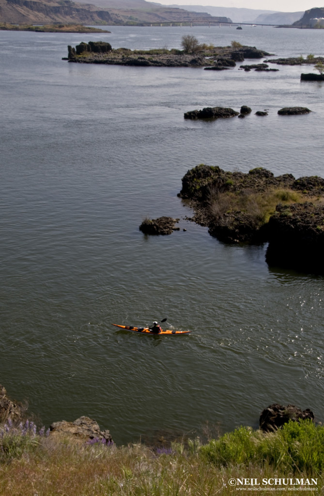
The dessert-like eastern gorge, east of Dalles, Oregon

by Neil Schulman

I leaned back as far as I could, hoping for the bow to rise. It was too late. The bow drilled into the back of the wave in front of me, burying me in water up to my waist and ending my umpteenth surf ride of the day. When my kayak resurfaced, I started paddling again, building speed to catch another swell.

The wave surged shoulder-high and green, its water comfortably warm on my bare arms. I rode about thirty yards, slid off, straightened my boat and started working on the next wave. Behind me, I could hear Karl cackling with the glee of a ten-year old. Kim was a few football fields ahead, yellow boat barely visible in a sea of whitecaps. As usual, there were no other paddlers in sight.

This wasn’t in Hawaii, nor was it a hallucination induced by a too-tight neck gasket. It was on a downwinder in the Columbia River Gorge, only a forty-five minute drive from my house in Portland.

For me, the Gorge is one of the best sea kayaking destinations on the planet. Portland and Hood River are both paddling towns, but somehow it seems the majority of sea kayakers have yet to take full advantage of the Gorge. I’ve spent 15 years kayaking in the Gorge, and in that time I’ve seen a grand total of three other paddlers.

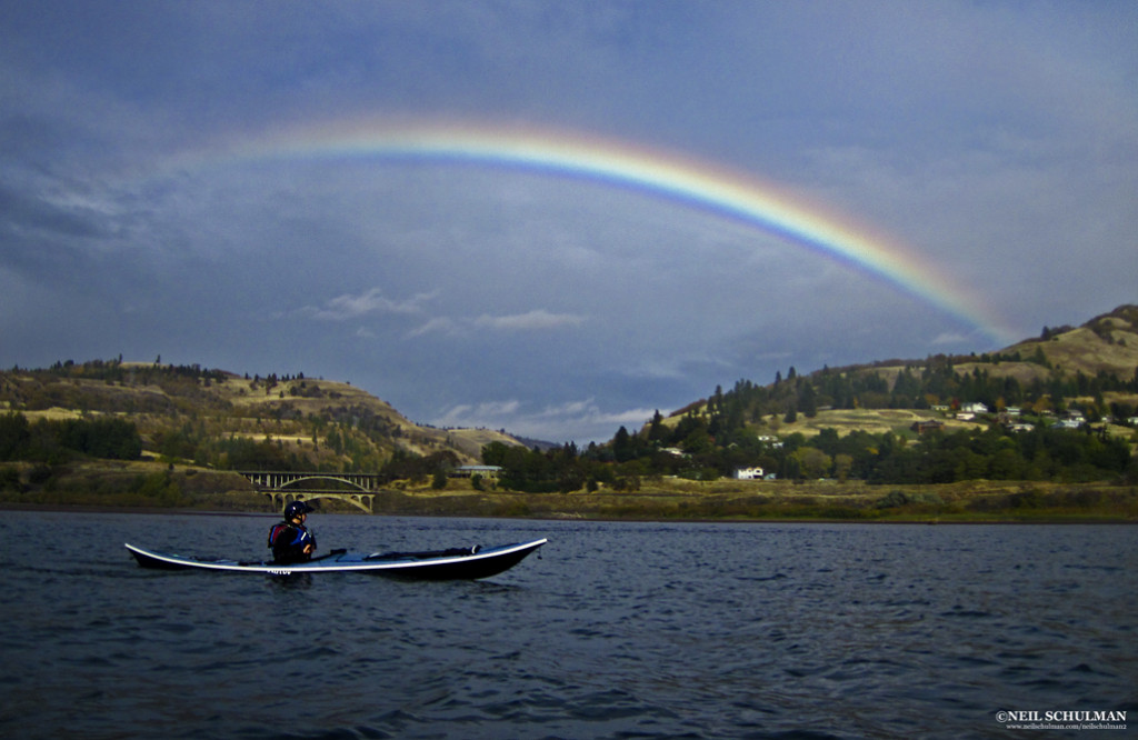
A rainbow arcs over the mouth of the Klickitat River

The Gorge

The Columbia River Gorge is a hundred mile-long, three thousand-foot-deep U-shaped valley straddling the Oregon-Washington border. Carved by ice-age floods, it connects the mild and wet climate of the western Cascade mountain range with the extremes of the continental high desert.

A National Scenic Area, the Gorge is defined by basalt cliffs, waterfalls and endless options for paddlers. Within it you can find rainforest and rain, sagebrush and sun. You can find gentle breezes and gale force wind, flat water, big waves, or swirling river currents.

Below Bonneville Dam, 40 miles east of Portland, the Columbia River zips seaward with a consistent current, strongest in spring, occasionally reaching 5.2 knots. Upstream of Bonneville and the Dalles Dam, you’ll find a lighter current, commonly less than 1.5 knots, but still moving downstream noticeably in spring, creating steep waves against the Gorge’s prevailing westerlies.

Conditions at the Gorge vary, but there’s almost always good paddling to be found somewhere. In calm conditions, there are scenic paddles of almost any length. When the wind’s up, plan a downwinder and surf until your arms are like rubber. When the wind’s too strong, head up a side stream and play in river current.

Gorge Tours

Here are two of my favorite calm-day Gorge tours. Both can be done as downwinders as well.

The Western Gorge: Dalton Point to Chinook Landing (16 miles)

Launch from Dalton Point near Multnomah Falls and cross to Phoca Rock midriver to paddle beneath dramatic waterfalls and sheer cliffs and through a delta teeming with waterfowl and bald eagles. Below Bonneville Dam, this run is done east to west with the current on a calm forecast or an east wind.

Give a wide berth to sea lions, which are often hauled out on the rock or playing in the eddylines around the rock. Then wall-crawl below the cliffs of Cape Horn on the Washington side below several waterfalls. Pass Reed, Flag, and McNary islands before crossing the mouth of the Sandy River, a series of shallow, braided channels where mixing waters attract a congregation of waterfowl, eagles, otters and migrating salmon.

Take out at Chinook Landing, a large public boat ramp, on river left. A side trip into the Sandy adds more play in current. In summer and fall when the current is weak, you can also do a portion of this trip from Dalton Point by paddling downstream in the morning and riding the afternoon wind back to your car.

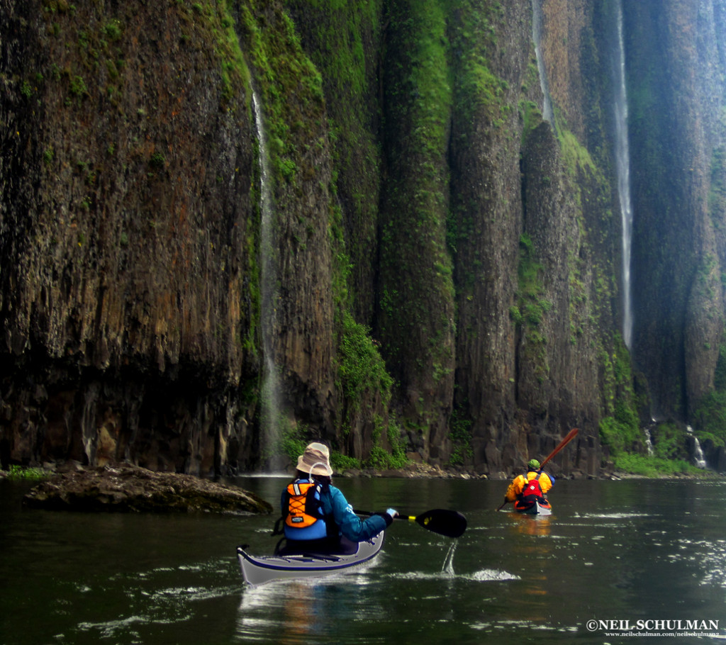
Paddlers beneath the waterfalls of Cape Horn in the rainforest at the western end of the Gorge

The High Desert Miller Island: (9 miles)

In the dry country East of the Dalles, Miller Island offers hiking as well as paddling. From the launch at Deschutes River State Park, circumnavigate the island clockwise: the north side, ominously named “Hellgate,” funnels westerlies.

Get out and hike to the top of the basalt cliffs that ring the island for stunning views of the Gorge and the island’s interior. In spring, you’ll see an array of wildflowers in bloom, including some found nowhere else in the world but the Gorge, which hosts a number of endemic plants.

The island was once a Native American village site for the many peoples that lived and traded along the Columbia River, such as the Wishram, Wasco, and Northern Paiute. Pictographs are visible from the water and along the cliffs. At the upstream end of the island, play in the wind and current eddies created by a series of rock islands, often under the watchful eye of several hundred Ring-billed gulls.

Continue around the island to Deschutes River State Park, or continue east to Maryhill State Park on the Washington side. The island is closed to camping, but camping is available at either Deschutes River or Maryhill.

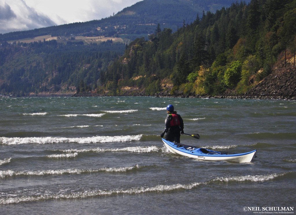
Jodi Wright launches into Force-4 winds near Hood River

Summer Downwinders

Windsurfers and kiteboarders have flocked to the Gorge for decades. The same factors that lured them—predictable wind, sunshine, and easy access—make it an ideal destination for sea kayakers to surf or to learn how to manage wind.

Gorge winds are caused by air pressure differences between the marine-influenced west end of the Gorge and the continental climate of the eastern end.

The eastern region is warmer from spring through fall, which creates lower air pressure compared to the cooler west. As air flows from high pressure to low, and the Gorge acts as an enormous funnel.

West winds strengthen and create bigger waves as they move east, so paddlers seeking more adrenaline should head toward Hood River or farther east. Kayakers seeking a milder day can paddle near Cascade Locks and Wind River, depending on the forecast.

Begin your downwinder by checking the forecast (see appendix) for several areas of the Gorge, and recheck conditions on the morning of your paddle. Look at the conditions before you set up your shuttle, and shift to a spot farther west if they look to intense.

Gorge wind strength is so localized it’s easy to match your skills by adjusting your paddle route to meet conditions. Expect westerlies to build during the day and ease around sunset.

My philosophy as a downwinder is simple: point downstream, surf, cackle with laughter, wash, rinse and repeat. Unlike surfing in the ocean, you won’t have to pound back out through the surf after each wave, get windows shaded by a wave closing out, or develop an embarrassing neck rash from neck gasket, sand, and saltwater.

When you want to surf again, just point downstream and go. If you miss a wave, there will be another one in a few seconds. When you need a rest, just float for a few minutes or work your way to shore and find a wind eddy.

Of course, every paddler has a different level of skill and comfort in wind. Wind below Force 3 is generally too small to surf; our group of skilled paddlers seeks wind in the Force 5 range (17-25 mph.)

Force 6 is exhilarating, but you’ll need to be on your game if anything goes wrong. In spring, strong current magnifies the wind-against-current dynamic and generates slightly larger sea states than the same wind conditions during summer.

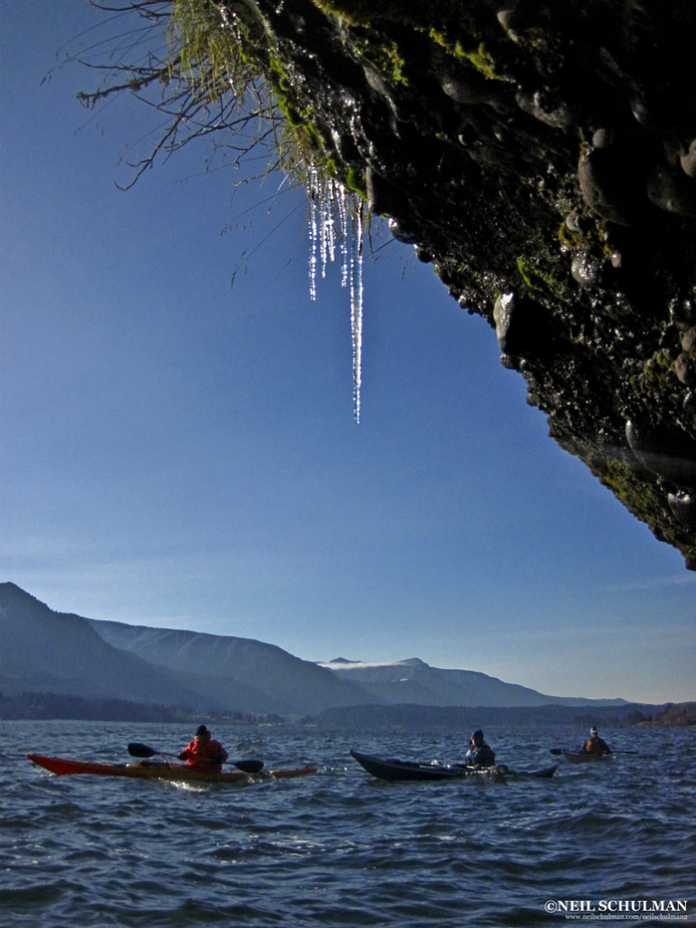
Icicles near Stevenson, WA on a cold day of the easterlies

Three Downwinders

Stevenson to Home Valley: 7 miles

Leave a shuttle car at Home Valley Park at the mouth of the Wind River, then launch at the public boat ramp in Stevenson, WA. The Washington shore is an intricate network of cliffs, coves and rock islands that provide breathtaking scenery and a good introduction to downwinders.

There are many nooks and crannies where you can rest, regroup, and practice turning upwind and downwind. In fall, spawning salmon in the Wind River put on an impressive showing.

Protect their spawning gravel by not walking in the shallows. After you shuttle back to Stevenson, walk down the block to Walking Man Brewing for a beer on the patio.

Viento State Park to Hood River (10 miles)

This run, located farther east, often has slightly stronger wind and larger waves on a westerly.  Leave a car at the Hood River City Marina, and then drive west and put in at Viento State Park ten miles to the west.

Start with a warm-up, paddle east (upwind) a quarter-mile to a large rock and group up in the wind eddy. Then cross to the Washington side and venture up the Little White Salmon River. Like the Wind River, it will be full of spawning salmon in the fall. Then surf upriver, crossing back to the Oregon side at the mouth of Hood River after passing its shallows, and take out at the city marina.

On this run you’ll encounter windsurfers and kiteboarders, and have a chance to play at the aptly-named Swell City. Then take your pick of Hood River’s many pubs where you can relax with a local brew.

Hood River to Mayer State Park (14 miles)

On this run, you’ll put in at the Hood River marina, follow several bends in the Columbia, and cross the mouth of the Klickitat River before ending at Mayer State Park. Wind is milder on the inside of the bends.

The lower Klickitat River is well worth a side trip to explore rock cliffs and oak woodlands, play in the river current, or watch for the local populaton of wild turkeys.  A half-mile upstream, paddlers reach the first set of riffles. I’ve spent entire days practicing ferries, eddy turns, peel outs, and upstream attainments here.

The Columbia pinches to its narrowest point between the mouth of the Klickitat and Mayer State Park, where waves are amplified as the accelerated current in this narrow passage meets the wind.

Save some energy to get your best surf rides of the day here, before heading for the Thirsty Woman Pub in Mosier.

The Easterlies

During winter, when the eastern high desert is colder than the temperate zone in the west, the entire Gorge wind factory runs in reverse. Colder air in the desert creates high pressure in the east and an east-to-west wind.  Just as a west wind creates waves in the east, an east wind creates waves in the western part of the Gorge.

On an day of easterly wind, the  aforementioned runs can all be paddled in reverse, from east to west: Home Valley to Stevenson, Hood River to Viento, Mayer to Hood River, etc. They will also reverse in difficulty: the further west, the stronger the wind and the rougher the conditions. The toughest conditions will be at Cape Horn, which is usually dead flat on a westerly. East wind flows with the current, which creates longer wavelengths for better surfing, but most east wind comes in the winter and is bone-chillingly cold.

Knowing the Wind

Windsurf-oriented smartphone apps such as iWindsurf, WindGuru, and NOAA weather are a boon for downwinders. They provide updates and forecasts, which make changing your itinerary easy as you head out to the Gorge.

The app can even send you updates when the conditions hit the perfect zone, so you can drop whatever else you’re doing to go paddle.

Downwinder Safety

Downwinders pose four particular safety issues: weather interpretation, wind management, group cohesion and sharing the river with windsurfers and kiteboarders.

Weather Interpretation

Humans are prone to exaggeration. Like the fish that got away, paddling stories tend to grow with the telling. In the Gorge, exaggeration can be dangerous.

I’ve heard many paddlers swear they were paddling in 35 mph winds, when I know for a fact it was really Force 4 (14-20 mph) from both my own measurements and the conditions report. This exaggeration leads them to honestly believe they have the skill to paddle in 35 mph winds, a recipe for biting off more than they can chew.

Learn to calibrate actual wind strengths with sea conditions and your paddling ability. Learn the Beaufort Scale, keep a paddling log, and refer to it when you’re wondering what 23 mph feels like.

Wind Management

You can’t control the wind, but you can control your boat in the wind. Turning your boat up and downwind and maintaining a course across the wind are basic skills for the Gorge.

Rudders and skegs help, but the paddler is the critical element. Learn to use paddle strokes and edging. You can lean forward and back, changing the trim of your kayak to make the wind help you turn. Grasping the effect of wind on a kayak requires experience in strong wind, which makes beginners nervous. Spend some time practicing these techniques with skilled paddlers in an onshore wind with a safe landing. When surfing, capsizes will happen.

Rolling in wind is much easier on the upwind side, and reentery and rolls often succeed because the paddler knows on which side they’re rolling. If someone does swim during a downwind run, there’s one major imperative: hold on to the deck lines. If the swimmer lets go, the empty kayak will quickly blow downwind while he or she stays in place, a challenging scenario for rescuers. In the warm water of summer, hypothermia usually isn’t a problem.

The east-wind runs of winter subject paddlers to more dangerous water temperatures.

Group Cohesion

Groups get easily scattered in the wind. Voices and whistles are often inaudible. Skilled surfers naturally speed ahead of more tentative paddlers, who are more likely to get in trouble.

One exception is during spring runoff with a westerly blowing, when skilled surfers tend to catch rides mid-current but make slow upriver progress while beginner paddlers who stay sheltered near the shoreline will get ahead of the rest of the surfers and remain easily visible.

In any case, a skilled paddler should stay upwind of (behind) the back of the group where they can see and respond quickly. Venturing out in the wind requires the same planning as any successful trip in challenging water.

Make plans for if the group gets separated, plan bailouts, map points for reassessment, maintain VHF communication and conduct an accurate assessment of skills.

Windsurfers & Kiteboarders

Paddling the Gorge means sharing the river with windsurfers and kiteboarders. While it can be unnerving at first, paddling with windsurfers is safe as long as they know you’re there.

Windsurfers tend to move predictably back and forth across the wind, while kayakers usually paddle downwind. That means they’ll be looking at the wide side of a kayak and they will spot a group easily. Windsurfers usually have a lot of control and can avoid you as long as you maintain a course.

Kiteboarders are connected to their kite by a cable, and I give them a wider berth to avoid the cable. Since the kite has more surface area and is higher aloft than a sail, they’re often slightly less predictable, though they tend to be on the river in lower winds than windsurfers.

I avoid the Hood River shallows because it’s popular with beginner boarders who have less control.

Now, back to my fun on a summer day in the Gorge. We ate up the miles until our smiles were exhausted. We found a sheltered cove along the northern shore for lunch.

While we ate and filled up our Tupperware with local blackberries, we watched six-person Hawaiian-style outrigger canoes fly downwind, training for an annual race through the Gorge. Later, we shared a pub with the racers and marveled again at how few sea kayakers paddle in the Gorge. It’s been overlooked for far too long.

Neil Schulman is a Portland-based photographer and writer. In his spare time, he also teaches kayaking and does environmental work. You can see his writing and photography at www.neilschulman.com/neilschulman2

Appendix:
Columbia Gorge Weather forecasts:
Weather.gov

Smartphone Apps:

iWindsurf
Windfinder

Sometimes you eat the gator. Other times, the gator eats your kayak.

Innova Kayaks, manufacturers of the inflatable Swing kayak (pictured above), received an interesting email, along with these photos, which read:

You may have seen the news stories across the nation since Saturday. I had incident with gator.

I wanted to thank you because as far as I’m concerned, being in an inflatable saved me from potential injury. I think if a gator had hit a hard shell kayak with as much force as it hit my Swing, I would have been tipped into water.

As it was, the other 2 air chambers stayed completely inflated and after the darn gator was done chewing and spinning around with its mouth full of deflated rubber, I was able to paddle quite a distance away and call for help.
Will miss my little yak, was fun for the month that I had it!

Thank you again.

Sea Kayaker has been informed that Innova, in cooperation with Adventure Times, the retailer where Sarah purchased her Innova Swing, will be replacing the partially eaten boat despite the fact that attacks by carnivorous predators are not covered under warranty. Sea Kayaker hopes to offer its support by sending her an alligator skin PFD… as soon as we find a manufacturer.