Breaking the Ice: Winter Paddling

Don’t let winter hinder your passion for paddling
Text and photography by Nicolas Bertrand

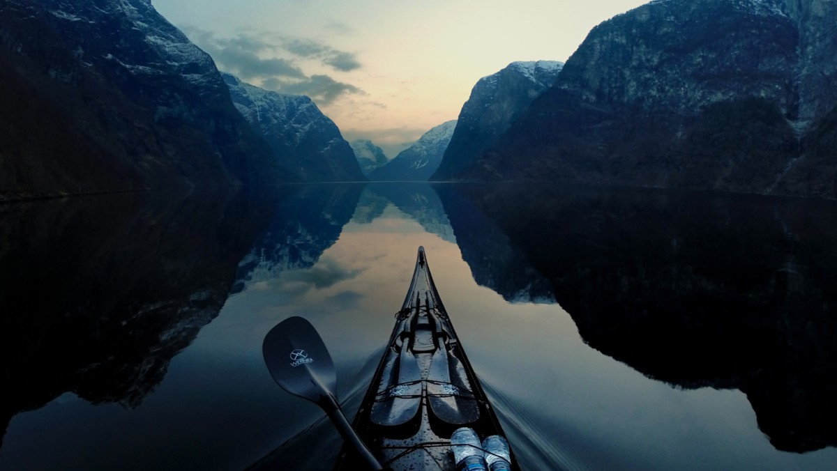
It’s a perfect winter day. With the previous night’s low of –15°C/5°F, I know there will be lots of ice in the St. Lawrence River in Montreal Harbor in the Canadian province of Quebec. The sky is clear, the air is still and the temperature will rise during the day, making the cold milder. For me, these are ideal conditions for a day of sea kayaking. 

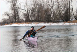
In the winter, even going for a single-day outing involves careful and methodical preparation. I don’t go out if I feel tired. For winter paddling to be safe and enjoyable, it requires being completely rested, and this morning, I am. With all the layers and gaskets I have to put on, getting dressed takes even longer than bundling up a toddler for the snow. The kettle whistles, and I fill my insulated bottle with hot water.

At Charron Island, my usual take-out (located midway down the St. Lawrence River, south-east of Montreal’s harbor), conditions are not good. A ribbon of ice chunks mixed with slush is drifting against the ice edge. The ribbon is uninterrupted—there is no place to launch from. At this distance, I am unable to tell whether I can cross the ice ribbon to reach open water. Furthermore, coming back across the ribbon might be impossible if the density of the floating ice increases during the day. I decide to continue my scouting.

I head back to the car to move a little farther upstream. There is another put-in at Longueuil. I don’t often launch from this area because the current is faster; however, today it may be my best option.

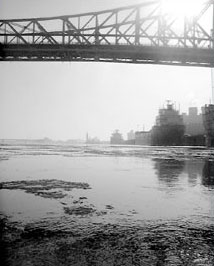
In Longueuil, I drop the kayak from the car rooftop directly to the snow and drag the kayak like a sled toward the water. Today, Montreal’s harbor is a complex world of ice; a majestic ribbon of moving colors and reflections, alive and whispering.

Before setting foot on ice, I dress for immersion in frigid water (in the range of 3°C to –2°C/37°F to 28°F). At this temperature, water is cold enough to cause pain to bare hands. I zip my dry suit, tighten my boot gaskets and put on a neoprene hood and a pair of neoprene gloves.

With the paddle in my left hand and the bow of the kayak in my right, I step onto the ice. Even after a few winters of doing this, I am always a bit nervous when first setting foot on an icy surface. Holding onto a 17-foot kayak and a 7-foot paddle and wearing proper immersion gear and a PFD makes this activity safe, but it still feels weird. Today, the ice cracks and squeaks. It is slippery, too. A few people ashore watch me slip and fall. Ouch! How can water be so hard?

As I continue my scouting, I notice a large area of water free of ice. Currents push the ice north of this area. By launching here, I will be able to get closer to the moving ice to assess its density. If it turns out to be too dense to paddle in, I can return to my point of departure. Because there is no wind, only the current affects the movement of the ice. I must pay close attention to the air surrounding me—if a breeze begins to blow, I must be aware of it and assess its influence on the movement of ice and on my planned route.

I walk 300 meters to yesterday’s ice edge. The demarcation between yesterday’s and today’s edge is sharp and clear. I can see pieces of ice pointing up in the air, frozen in place after being pushed up by the current, then clear translucent ice beyond.

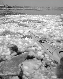
The final 30 meters consists of ice formed over the last 12 hours: a bizarre patchwork of white ice chunks called shuga (so named because of its resemblance to powdered sugar). The shuga drifted, aggregated and, surrounded by a thin, transparent layer of newly formed ice called nilas, froze in place. The nilas, approximately one or two inches thick, flexes under my bodyweight.

Walking on nilas gives me chills, especially when it’s brand new and still elastic, like today. Bending down, I drag the kayak by the coaming, ready to lie down on the kayak should the ice give way. When possible, I hop from one chunk of shuga to the next, avoiding the nilas as much as possible. I see little bubbles moving underneath the ice. Water finally! With the kayak resting on a piece of shuga, I get in, secure the spray skirt and push myself into the water.

From where I sit, it looks unlikely that I’ll be able to paddle at all today. There are traces of water in my immediate surroundings, but in the distance, there seems to be only ice. It looks like I would need snowshoes to get anywhere.

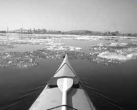
As I proceed, however, one channel opens up to another, and lines of frazil (small plates of ice just under the surface of the water) are easy to cross. Frazil gives the water a slick, oily feel. When it hardens, it turns into slush or semi-solid snow. Slush can be paddled, but doing so can become very tedious. Today it isn’t. The ice that looked too dense actually has enough water to be paddled.

Little ponds among the ice fields grow and shrink here and there. In spite of the –5°C/23°F air temperature, the warm sun and still air make for comfortable paddling conditions. I decide to go toward the Old Port of Montreal, where I might grab a hot drink. I hope that the floating ice I see will continue to look more packed than it really is.

After some hit-and-miss route-finding through the ice, a few chunks of which hit the kayak, I reach the Old Port. A couple of ducks sit on the thin ice of the still-water basin. At first, the ice is like paper, then it thickens very progressively. I break over five kayak lengths of it until I find ice too strong to be broken by the paddle, but not strong enough to support the kayak’s weight. Unable to dig my paddle in, I can’t exert enough force to advance. Because the kayak itself is not supported by the ice, I can’t stand or even crawl on it. It looks like my planned stop won’t be possible today. This is yet another reminder that, in the winter, you don’t always get to do what you’d like, so you can only take advantage of what the conditions allow. Flexibility is a must.

In the summer, navigating your way out of the Old Port is hellish because the area is overrun with powerboats and jet skis. High speeds, drunk drivers and powerful currents make the area unpleasant, if not outright hostile, to sea kayakers.

But today, thanks to the cold, there is absolutely no one in sight. The river is all mine. On my way back, I drift down along the frazil. It is like being on a magic carpet ride. Sitting in frazil, the kayak is surprisingly stable. I change gloves and drink a little warm water. I realize that I need to start making my way back. The sun is getting lower and I will eventually become tired if I stay out too long. It is wiser and safer to stop before fatigue sets in.

Practical Aspects

This article addresses the specifics of paddling in below-freezing temperatures with ice and frigid water, but it does not cover the basics of safe sea kayaking in cold water. Knowledge about self-rescue and proper clothing for immersion in cold water is a prerequisite.

Extending your paddling season to include the winter months should be done only after you have developed strong safety skills during the regular season. Be aware that rescue potential is different for winter conditions than for summer.

The Coast Guard probably expects outdoor enthusiasts to be on skis rather than in kayaks at this time of the year. Their ability to travel by boat will either be significantly reduced or made impossible by ice, so assume that you are on your own. Last winter, two ice fishermen near Montreal had gone on an unplanned “cruise” when the ice they were fishing on broke loose from shore. A helicopter had to fly in from Ontario to rescue them.

Assistance can take several hours if it’s available at all.

Being Dry

For winter paddling, the usual cold-outdoor-activity wisdom applies: Avoid sweating, and stay dry. This is especially difficult to achieve when enveloped in a dry suit, Gore-Tex or not. Gore-Tex breathes, but may not be able to allow body condensation to evaporate entirely during even moderate exertion. Being wet in winter is perilous.

Even winter-sports amateurs are generally aware of the importance of staying dry in subfreezing temperatures. When your winter sport is sea kayaking, the challenge of being dry is even greater. A good dry suit, waterproof gloves and neoprene boots make it possible to stay close to a state of dryness.

Using a wetsuit, river shoes and pogies is a mistake in subfreezing conditions: They won’t keep you warm enough while you’re paddling and will be dangerously ineffective if you wind up in the water. Aside from the danger of paddling with improper equipment, you’ll be so cold, it won’t be any fun.

I regularly go out for five- to eight-hour intervals in temperatures as low as –15°C/5°F, and even if there is a breeze adding a wind-chill factor, I’m comfortable most of the time. I can’t stress enough how important a dry suit and waterproof gloves are to safe winter paddling.

For my outings, I start by layering synthetic fleece. The amount of fleece I put on depends on temperature and wind speed. For conditions below –5°C/23°F, I start with a base of four layers. The first layer is moisture-wicking fleece long underwear, which covers my legs, torso, arms and the bottom of my neck, in the area just below the dry-suit gasket.

The second layer is an expedition-weight fleece top. The third layer is a farmer john fleece garment, covering my legs and torso but not my shoulders and arms. This one-piece farmer john is especially useful for covering my back and waist comfortably, preventing cold gaps in clothing. The fourth and final base layer is a big, heavy, thick fleece top.

Over all four layers, I put on my dry suit. The last step in putting on the dry suit is to expel air from it. With an inch of the zipper left to close, I crouch, round my back and try to squeeze out as much air as I can, then close the zipper. Standing up, I can feel the outside air pressure pushing the fabric against my skin.

The spray skirt and PFD form a final layer. My legs have a little less fleece coverage than my upper body, but the closed kayak provides a means of protection from the cold.

The golden rule for staying dry is to adjust the intensity level of the activity to the current heat needed by the body. If you’re feeling cold, paddle a little more vigorously until you warm up a bit.

Don’t overdo it and reach the point of sweating. If you are too warm, slow down. The goal is to be as dry as possible. I recently switched to a Greenland paddle and found that it lets me more finely tune my paddling pace, especially in light cadences, allowing better temperature control. When it is below freezing, you’ll feel drier than you will at near or above freezing.

The condensation that builds up inside a dry suit will ice up the inside of the fabric. At a break, simply turn your dry suit inside out, reversing it down to the knee, and brush off the icy buildup.

Extremities

If your hands, feet and head are cold, your core is probably not warm enough. Warm waterproof gloves are a must. I find that fleece-lined neoprene gloves work best.

Make sure the seams are glued and watertight. Good neoprene gloves are expensive and can also wear quickly, but they are reparable. I take two pairs on each outing and alternate them throughout the day as one pair gets damp, usually every two to four hours.

At home, I test for leaks regularly and repair them as needed with Aquaseal neoprene sealant. 

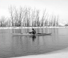
Even with perfect gloves, your hands will eventually become humid, either from water infiltrating the wrist areaor from perspiration. Your hands are very vulnerable to low temperatures.

Cold and humidity can affect tendons and finger articulations, making them stiff and painful for several hours after paddling. According to professional divers working on the maintenance of a low-temperature aquarium in Montreal, frequent and repeated exposure of the hands to cold water can lead to arthritis.

Do not wear damp gloves for too long. Your hands will thank you for frequent glove changes.

Another good practice to adopt is to wiggle your fingers while paddling, which will keep them loose and keep your blood circulating. Use very light pressure when pushing the paddle shaft so you can wiggle your fingers at the same time. The increased blood circulation in your hands will keep them warm.

Neoprene boots and wool socks keep feet warm and dry. I use neoprene mukluks and find them to be very warm. Allowing wiggle space for your toes is very important.

A common mistake is to wear boots that are too tight, which hinders blood circulation and causes cold feet even if your core temperature is ideal. The same is true with too-tight gloves.

A skull cap will keep your head warm. Properly adjusted, it will even prevent water from entering your ears during immersion. I use a neoprene shell lined with Lycra fleece that fits snugly around my face.

Finally, a scarf or facemask is nice if the wind is blowing. The mountaineering-style neoprene facemask covers from the nose down and secures around the neck, protecting it as well. Under some conditions, small splashes and wind can cause blisters on your face quicker than you can say “freeze!” A good facemask will let you fully enjoy the beauty of a snowstorm from an unusual setting. Are we warm enough now?

Before Ice

Maybe the biggest mistake you can make in sea kayaking is overconfidence. Don’t assume that just because you can reliably roll or do a recovery in cold water on a fall day that you will be able to do the same among chunks of ice in February. Gradual preparation and practice are essential.

How will your body react to frigid water? Is your equipment up to the task? Failures that might be annoying in warmer conditions are likely to become catastrophic in the winter. There is only one way to find out if you are ready: Go for a swim.

Observe the local conditions regularly for the area you want to paddle over the course of fall and early winter. When a little ice begins to form in the area, paddle out on the water (appropriately dressed, of course), exit the kayak and swim.

This exercise should be done near shore, in chest-deep water with a partner nearby. Take a look around to see if anyone might see you capsize. It is wise to warn passersby about your drill. They might think that the situation requires an emergency call and take action. 

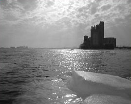
Once in the water, observe the effect of the cold on your body, but come ashore before you get hypothermic. Be aware that poor judgment is one of the early symptoms of hypothermia. Other deceptive symptoms include apathy, confusion, inability to solve problems, unawareness of a dangerous situation and making no effort to protect yourself. Your partner should be reliable, dressed for immersion and able to drag you out of the water. In all cases, be very cautious and try to recognize the early symptoms of hypothermia, and have your partner closely involved in keeping you safe.

When you are done swimming, remove your gloves and immerse your bare hands in the water. If the water is frigid, it should convince you to keep your gloves on at all times.

Frigid water can render your hands useless in less than 30 seconds. Furthermore, taking bare hands out of the water into subfreezing air temperatures is also very painful. It’s essential to wear gloves at all times when walking on ice or when paddling where the water is cold, especially when ice is present.

At near-freezing water temperatures, even with a dry suit, you can actually feel your body heat quickly draining out. It can’t be stressed enough how deadly frigid water is. Experience it in a controlled manner before committing yourself to the challenge of winter paddling.

Practice swimming and reentry in cold water close to a beach, even if your roll is bombproof. At some point, you will fall in the water while walking on ice. If you paddle in icy conditions, assume you will regularly wind up in the water, whether you want to or not. This is especially true in late winter or under conditions where breaking through the ice will be either more frequent or certain.

A Little Extra Advice

Your kayak must stay afloat no matter what happens. Use float bags in the forward and aft compartments and place all your cargo in dry bags. Should a watertight hatch fail, the float bags will ensure proper flotation of the kayak.

Taking extra warm clothes and food is a good idea. In dry bags, carry a complete change of dry fleece, a winter coat, dry mitts, a hat, extra gloves, boots and a warm sleeping bag if you are in an area that is even a little remote. Besides adding flotation, these items can be very useful in case of an emergency situation.

Equipment

One extra piece of equipment specific to winter paddling is a set of ice claws, or any other object sharp enough to bite the ice, enabling you to get a grip in it. On my first outing on ice, I was paranoid enough to take along an ice axe.

Although an impressive prop to display on the deck of your kayak, the ice axe is bulky, rusts easily and sinks quickly. A paddler’s knife, either a sheath knife or a folder with a locking blade, can be a useful tool to get a grip in the ice, but make sure the tip is not filed off, as is sometimes the case.

A blunt tip will make it more difficult to get a secure grip in the ice. The fact that knives do not float also reduces their utility. In this sense, ice claws are a better choice. They are easy-to-make, effective tools used to drag yourself out of the water over slippery ice. 

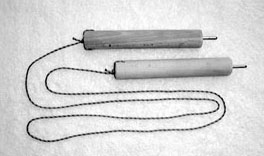
To make your own, cut a 1-foot long, 1 1/4-inch thick dowel in half. Drive a 2-inch-long screw about an inch into the center of the end of each stick (or farther if using a longer screw).

Use a hacksaw to cut off the head of each screw and file the tip to a point sharp enough to dig into ice. (The important thing is that the screw is firmly embedded in the dowel and will resist pulling. It shouldn’t move at all or break away from the dowel under some force.

If you try to pull yourself over a lawn with it, you should damage the lawn, not loosen the screw. Force exerted on the dowel will be less on ice, where there is less friction than on a lawn.) On the other end, drill a hole through the dowel approximately an inch from the end, and thread a 4-foot piece of small rope through the hole to tie the claws together. Carry them in a convenient, accessible location. Ice claws cost almost nothing to make and can be truly useful.

Portable Heat

A warm water bottle is another excellent way to stay in the comfort zone. It is a surprisingly effective, portable heating device. Use a Thermos or MSR bottle parka that you can carry under a deck bungee cord. You can also wrap a hot water bottle in several layers of fleece and carry it inside the kayak.

Fleece is an excellent insulator. Feeling cold? Sip a little hot water. Be careful not to overuse it, however. If you become hot and sweaty, your clothes will dampen, and shortly thereafter, you will be cold and miserable unless you stop to dry out in the wind and change your damp clothes.

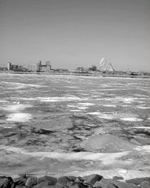
Even if you don’t feel damp, it’s always nice to stop for a dry out. I try to do it every four hours or so. At these times, the warm water bottle plays an essential role. When you remove the dry suit and roll it down to expose the fleece to the wind to dry it out, your body experiences a tremendous heat loss. Typically, I try to stand in the windiest place possible with my arms raised, turning to expose my back, torso and legs.

This makes even the most hardened northerners shiver unless they drink warm liquid!

De-icing

In subfreezing temperatures, ice will eventually form on the kayak and paddle shaft. This glaze is pretty at first, but can build up and become heavy. Use something hard to break it, such as the ice claw handles, which are very effective.

Gently tap the kayak and paddle shaft with the ice claw handle to break the ice. Dipping the paddle shaft in water will make breaking the ice easier. Cold as it is, water is still warmer than ice. It will weaken the ice, especially the bond between the paddle shaft and ice. As the owner of a plastic kayak, I can bend my boat in soft spots to help break the ice buildup.

The type of plastic used in my kayak remains flexible without breaking well below freezing. A flexible skin-on-frame kayak is very easy to de-ice. Of course, using a rudder or skeg is impossible under freezing conditions, as they become jammed with ice. My advice is to retract or remove them.

Scouting for Open Water

As with any kayak trip, a day of winter paddling starts at the water’s edge. In summer, getting to the water is usually straightforward: drive to the water, park, unload and launch. In winter, it’s not always as simple. A weak ice edge, where ice meets water, can complicate entering the water or make it impossible. Drifting ice, at the mercy of wind and current, can alter course during the day, and rapidly evolving ice conditions can hinder landing. Thus, scouting is essential to get to open water and to note places to take out if the ice shifts.

Finding an acceptable put-in is part of the joy of winter kayaking, particularly if it involves a bit of a hunt. Changing conditions are also a large part of the fun: In winter, no two days of paddling are ever the same.

When winter conditions are warmer, such as early and late in the season, searching for places with the most floating ice is often a good reason to drive around. When ice is scarcer, I tend to paddle in the areas where it is more concentrated, usually channels with less current.

Snow coverage may mean I have to park in places more distant from the river, but it is easy to pull a kayak across the snow—even a one- or two-mile walk is manageable if the snow is compact or if I use snowshoes.

My waterproof kayaking footwear is warm and sturdy enough to allow for walks of this distance. Not Ice, Not Water

Probably the worst thing a kayaker can encounter while winter paddling is the combination of ice and water that’s too firm to paddle through, but not solid enough to walk on.

Conditions can change every day, every hour. Most of the time, it’s no problem to put in and get out. I’ll walk to a solid ice edge, sit, secure my spray skirt and push myself in. To make a landing on the ice, I’ll paddle fast, aiming the kayak directly at the ice edge.

If I have enough momentum, the kayak can even slide far enough to get me over solid ice.Sometimes it’s possible to get around some fairly strange mixtures of ice by crawling, jumping and swimming. These types of endeavors can actually be fun—sometimes more enjoyable than paddling itself.

Jumping from one piece of ice to the other, discovering which ones are large enough to support you and which ones are not, even feeling the ice move under your foot and sink slowly is very enjoyable. Crawling in slush is also enjoyable. These are experiences I like very much. It is always so new, I feel like a child discovering the world.

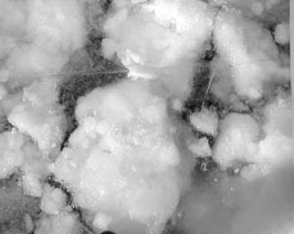
Finally, beware of current going under the ice edge. On May 16, 1999, two river kayakers on the Copper River, in the Wrangell–St. Elias National Park, Alaska, were dragged under the edge by the current.

Fortunately, they lived to tell their tale, which involved being under an ice edge for a full minute. Under the right circumstances, even a weak current can be strong enough to drag someone under the edge.

Cheated by Time

Somehow, time moves faster when I paddle in the winter than in the summer. Maybe this is an indication that paddling is more fun in the winter! Maybe it is the solitude or the wonderful spectacle of ice, its colors and sounds.

Whatever the reason, I get the most thrill and satisfaction out of sea kayaking in the winter. With adequate preparation, the right equipment and the proper skills, you might also discover that the snowy months of the year are the best for paddling.

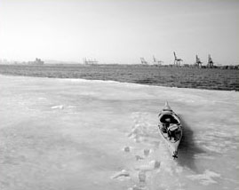
Winter paddling can be contemplative, even a little magic. Dazzling as it is, however, this is a hostile environment. There is no such thing as safe ice.

Thin or not, it can always be treacherous. Each winter in Quebec, there are casualties when people break through ice. The formation and transformation of ice is a constant evolution, every moment a wonder. But equipment and procedure are essential to paddling safely in the winter.

The beauty of the setting must not take precedence over pragmatism and awareness of danger.

I’ll leave you with my main piece of advice on paddling in the winter: Don’t do it unless you are totally confident about it. It’s better to be prepared and safe so that you have plenty of winter paddling experiences ahead of you.

Nicolas Bertrand is a schoolteacher from Montreal, Quebec, Canada. He has paddled most of the Gulf of St. Lawrence’s north coast, and he started winter kayaking in 1999.

Resources

Ice Conditions
Canadian Ice Service (http://ice-glaces.ec.gc.ca/)
The Canadian Ice Service is a complete source of information on ice in Canada. Although not designed specifically for sea kayakers, it is an essential reference for current conditions.
National Ice Center (www.natice.noaa.gov)
The National Ice Center provides current conditions for the United States.

Additional Information
The Minnesota Department of Natural Resources website has some helpful information on ice safety and the fabrication of ice claws
Wrangell-St. Elias Park & Preserve
“An Account of a Kayak Trip Gone Wrong,” National Park Service, May 16, 1999 (www.nps.gov/wrst/kayaksafety.htm)

A Stroke of Luck ( Kayaking Trip in Southern Thailand)

We slipped into the water fronting our camp on the jungle’s edge, donned our masks and fins, and kicked through the shallows to reach the deeper water where the coral thrived.

Beneath us were dozens of blue and red speckled sea urchins. The jellyfish were out in numbers, and we had to keep alert to try to avoid their stings.

A few minutes later, we reached the edge of the shallows, and below us were towers of coral rising some six to eight feet from the bottom. Brilliant orange clown fish hid in the swaying tentacles of the anemones while graceful angelfish grazed the surface of the coral.

Suddenly and inexplicably, the water was crowded with jellyfish, and their stings became more numerous and impossible to dodge. A current began to draw us away from shore.

Alarmed, we both surfaced. Looking toward shore, we could see that the coral we’d glided over minutes before was exposed all the way to the beach, rising approximately four feet above the surface of the water. The effect was quite disorienting and made the beach look strangely unfamiliar.

For a moment, I thought we had drifted in a current, but our tent and kayak were still on the shore directly in front of us. Why was all that coral suddenly exposed? Ryan considered the possibility of a tsunami, but that seemed incomprehensible. We wrestled with this strange current and tried to make sense of the rapidly and radically changing surroundings.

Our kayaking trip in southern Thailand began three days earlier, on December 23, 2004. We had traveled by train a thousand kilometers south along the Malay Peninsula with bags containing our kayak, camping gear, clothes and food. We arrived at the ranger station on Ko Adang, one of several islands in the Tarutao National Park on the southern west coast of Thailand. 

We camped at the edge of the beach backed by a lush jade-green jungle blanketing the mountainous island. We spent two days at this idyllic location, paddling the surrounding waters and enjoying scenic jungle hikes to waterfalls and cliffs. We were elated by each new wildlife discovery—a five-foot-long monitor lizard, crab-eating macaques, a small shark, a flying squirrel and numerous sea eagles.

On Christmas morning, we packed up our belongings and loaded the kayak with enough supplies for a leisurely 10-day tour of the more isolated islands.

We crossed to Ko Lipe, an island crowded with resorts and foreign tourists. After landing on Pattaya Beach and purchasing some “Christmas treats” from one of the resorts—salty potato chips and cold sodas—we resumed our circumnavigation of Ko Lipe under sail and headed for the western shore of Ko Adang.

As we came around the western point of Ko Lipe, a sudden gust caught our sail and capsized us with breathtaking speed. We bailed out, and Ryan dived down to unhook the sail so we could right the kayak. With the boat upright, we pulled the sea sock inside-out to drain the water and climbed back aboard. The pump made fast work of the water in the aft sea sock, and we were off paddling again. Our wet clothes were actually a welcome cooling-off from the 95˚F heat.

An hour of paddling hard against the wind brought us to more sheltered waters on the western shore of Ko Adang. Paddling close to shore, we looked for a campsite and a place to dry our things. We arrived at our beach and set about wringing out our gear and laying it in the sun to dry.

Two park rangers approached and claimed it was dangerous to camp away from the ranger station where there would be no support if we got into trouble. In Thailand, people rarely camp without facilities nearby, making us an anomaly to them.

Although they asked us to try to paddle back that night, we knew we were too tired and darkness was approaching. We set up camp as high on the beach as possible without going into the jungle, tucking our tent into the shade of a tall, rounded boulder that sat about three vertical feet above the reach of high tide.

That evening, we enjoyed a Christmas supper of “turkey casserole in a bag.” After dinner, we strolled down the beach among the hermit and scuttle crabs, under the light of a brilliant full moon. We visited with three other kayakers who were camped nearby. Their tents, adorned with Christmas lights, were set on a sandbar next to a small creek.

December 26 was clear and warm and notably devoid of the ever-present wind. As we ate breakfast, we waved to our fellow kayakers as they paddled by en route to their next camp. The water was quite still, so we decided to go snorkeling around 9:45. It was about 10 o’clock when the water around us began to recede, exposing the coral beds.

We needed to get back to shore, but the coral would have been impossible to walk over with its saw-like edges and clusters of spiny sea urchins, now exposed to the quiet morning air.

We swam parallel to the shore, looking for a clear path to the beach. The current shifted direction, and within seconds, the water had become opaque with sand churned up from the bottom. It was as if it were caught in a blender.

With the current now pushing us toward shore and the jagged coral, we kicked and stroked frantically against the press of turbid water, trying desperately to keep from being tumbled across the coral and the needle-like urchin spines.

Our anxiety was at its peak, and we felt completely helpless and at the mercy of the water. Adrenaline had kicked in, but we made no progress in the few seconds that we tried to swim against the current.

As I realized that we were being pushed rapidly toward the beach, I was filled with dread: We were flotsam about to be smashed against the coral. All we could do was pray for our lives.

Suddenly the coral was covered by the wave. Ryan pulled my arm and yelled, “Swim with it!” Turning and swimming with the wave, we tried to clear the coral and reach shore.

We kicked as hard as we could, certain our lives depended on it. In our helpless state, swimming was the only thing we had control over and seemed the only reasonable course of action. I yelled to Ryan, “My flippers are falling off!” Reaching back, I managed to reattach my heal strap and quickly resume kicking.

Feeling powerless against the immense force of the water, I kept screaming to Ryan, “Don’t let go of me!” He gripped my arm tighter and yelled back, “Keep kicking!” We could see the head of the wave 15 feet in front of us, foaming and churning as it tore into the exposed coastline. The enormous surge of water lifted us far above the ragged claws of the coral.

In five interminably long seconds of riding the wave, we were almost on the beach. We watched the wave around us as it crashed against the shore. As the water began to recede, our feet touched the sand.

We stood in chest-deep water and tore off our flippers. The sea was pulling us back with incredible force as we struggled to climb up the beach. Finally, we freed ourselves from the water’s pull. The wave had left us on the beach without a scratch.

We ran toward our camp as a second surge of water pushed up the beach even higher than the first. It swamped our tent and began to pull our kayak and gear out to sea. We frantically grabbed whatever was in front of us and threw it higher into the jungle.

The kayak was the first priority. We hauled it as high as we could. Thorny shrubs in the undergrowth at the top of the beach scratched our legs up to our knees and punctured our bare feet. At the moment, we weren’t concerned about the thorns—watching only for another wave, we scrambled to save our equipment.

The surges continued for another 20 minutes, but none were as large or as powerful as the first two. We put away our fears about being pulled back out to sea and salvaged what we could of our ruined camp. Our tent was entangled in the low limbs of a large tree, its sturdy aluminum poles twisted like rubber tubing.

The gear inside was saturated with seawater, and the continuing surges kept trying to pull the tent out to sea. We struggled to hold on to it and eventually were able to get it into the jungle to higher ground. The mesh door had been torn to shreds, and our ID cards and many of our supplies had been washed away. Every piece of gear we could retrieve was soaked with gritty seawater and fouled with jungle debris.

We took inventory to see what the sea had claimed. Footwear was our main concern, as we were now feeling the pain of the thorns, and to go anywhere on the beach, we had to contend with a gauntlet of sea urchins and coral fragments. Several hundred feet down the shore, a small creek had been turned into a torrent of brown water as the land shed the water that had washed over it.

A Thai fisherman came running down the beach toward us. His eyes were wide with terror. He told us that he had lived on the island his entire life and that nothing like this had ever happened before.

His family and his home down the beach were high enough to escape the surge of water, but he kept repeating that a foreigner had died on the coral on nearby Ko Rawi. Although feeling exceedingly grateful that we were OK, our understanding of the scale of what had happened and our concern for others in the area was rising. We wanted to get back to the ranger station as quickly as possible.

The Thai man came and went numerous times, often returning with a piece of our equipment—a cooking pot, a camp chair kit, bits of webbing. It was comforting to have him near.

While I gathered gear around the site and set it out to dry, Ryan walked down the beach to search for the rest of our belongings. He returned with cooking utensils, insect repellent and, most important, sandals. Meanwhile, several long-tail boats congregated offshore, seemingly unsure of what to do. After a while, they started their motors and headed south at high speed. We assumed they were moving to safer waters.

After waiting out two hours of calm seas, we packed our boat. We shared some oranges with our Thai neighbor, and he helped us launch. We paddled briskly to deeper waters, as the shallows no longer felt secure.

Our trip back to the ranger station took over an hour as we took a course much farther from shore than usual. Our kayak meandered through some unusual swirling currents that certainly didn’t help calm our frayed nerves.

Approaching the ranger station, we saw the rangers we had encountered the day before. They ran to meet us and helped with our kayak. They were very glad to see us back safe and excitedly voiced their concern for us when the waves hit.

We felt safe being back at the station, but there was rumor of a larger wave that was to approach in the next hour. With the help of the park staff, we quickly transported our boat and gear to higher ground.

Most of the foreigners we’d seen typically kept to themselves on vacation, but here at the ranger station, a camaraderie emerged among all of us. They gave us dry clothes to change into and iodine for our wounds. We gathered around a small satellite television to watch Thai news coverage of the tsunami. Understanding little of the language, we found it hard to comprehend the enormity of the disaster.

The next morning, we were able to get calls through to our parents. They informed us about the horrific and climbing death toll and the numerous countries affected by the disaster. We realized just how incredibly fortunate we had been that the wave hadn’t been larger where we were. Losing some of our gear—even expensive electronics like our camera and GPS—seemed insignificant next to the loss of so many lives.

Over the following two days, many foreigners and Thais left the island. We stayed behind with a handful of other foreigners, as we believed the mass exodus of tourists would overload the available transportation. We cleaned and dried our gear and sewed up our tent.

Three days after the tsunami, we returned to the campsite and found many of our things at the edge of the jungle and in the shallows, including shoes, dishes and ID cards. When we returned to the ranger station, we met up once again with the kayakers we had visited with on Christmas Day.

They had been kayaking near a bay on Ko Rawi when the wave hit and had paddled farther offshore for a few hours to escape the destruction on shore.

Only four days after the tsunami, we resumed our original plans and paddled to the other islands of Tarutao National Park. We spent another week exploring new shorelines, beaches and coral reefs.

We had been spared the full impact of the tsunami. Although geographically close to the epicenter, we were traveling in the lee of Sumatra and Ko Rawi. Cut off from the news that barraged our families back home with scenes of destruction and loss of life, we enjoyed the last days of our holiday.

Memories of that time spent in a beautiful land now seem decidedly bittersweet as we sift through news in the aftermath of the tsunami—images, statistics and stories of lives destroyed.

Karen and Ryan Kurytnik are avid paddlers and have guided trips in the waters surrounding Vancouver Island. Karen is working on her Ph.D. in educational psychology, and Ryan is completing medical school. They are based in North Vancouver, BC.

Editor’s note: We at Sea Kayaker encourage our readers to support the relief efforts taking place in the countries devastated by the tsunami. John “Caveman” Gray, Sea Kayaker contributor and veteran kayak guide operating in Phuket, Thailand, reminded us that the quick resumption of tourism is essential to the area’s recovery. As evident in the Kurytniks’ story, many places returned to normal activities soon after the tsunami struck. Direct aid is, of course, essential, but booking travel to the areas supports those families whose income is tied to tourism.


Playing in the Wind Factory: Sea Kayaking the Columbia Gorge

The dessert-like eastern gorge, east of Dalles, Oregon

by Neil Schulman

I leaned back as far as I could, hoping for the bow to rise. It was too late. The bow drilled into the back of the wave in front of me, burying me in water up to my waist and ending my umpteenth surf ride of the day. When my kayak resurfaced, I started paddling again, building speed to catch another swell.

The wave surged shoulder-high and green, its water comfortably warm on my bare arms. I rode about thirty yards, slid off, straightened my boat and started working on the next wave. Behind me, I could hear Karl cackling with the glee of a ten-year old. Kim was a few football fields ahead, yellow boat barely visible in a sea of whitecaps. As usual, there were no other paddlers in sight.

This wasn’t in Hawaii, nor was it a hallucination induced by a too-tight neck gasket. It was on a downwinder in the Columbia River Gorge, only a forty-five minute drive from my house in Portland.

For me, the Gorge is one of the best sea kayaking destinations on the planet. Portland and Hood River are both paddling towns, but somehow it seems the majority of sea kayakers have yet to take full advantage of the Gorge. I’ve spent 15 years kayaking in the Gorge, and in that time I’ve seen a grand total of three other paddlers.

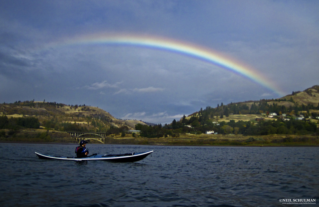
A rainbow arcs over the mouth of the Klickitat River

The Gorge

The Columbia River Gorge is a hundred mile-long, three thousand-foot-deep U-shaped valley straddling the Oregon-Washington border. Carved by ice-age floods, it connects the mild and wet climate of the western Cascade mountain range with the extremes of the continental high desert.

A National Scenic Area, the Gorge is defined by basalt cliffs, waterfalls and endless options for paddlers. Within it you can find rainforest and rain, sagebrush and sun. You can find gentle breezes and gale force wind, flat water, big waves, or swirling river currents.

Below Bonneville Dam, 40 miles east of Portland, the Columbia River zips seaward with a consistent current, strongest in spring, occasionally reaching 5.2 knots. Upstream of Bonneville and the Dalles Dam, you’ll find a lighter current, commonly less than 1.5 knots, but still moving downstream noticeably in spring, creating steep waves against the Gorge’s prevailing westerlies.

Conditions at the Gorge vary, but there’s almost always good paddling to be found somewhere. In calm conditions, there are scenic paddles of almost any length. When the wind’s up, plan a downwinder and surf until your arms are like rubber. When the wind’s too strong, head up a side stream and play in river current.

Gorge Tours

Here are two of my favorite calm-day Gorge tours. Both can be done as downwinders as well.

The Western Gorge: Dalton Point to Chinook Landing (16 miles)

Launch from Dalton Point near Multnomah Falls and cross to Phoca Rock midriver to paddle beneath dramatic waterfalls and sheer cliffs and through a delta teeming with waterfowl and bald eagles. Below Bonneville Dam, this run is done east to west with the current on a calm forecast or an east wind.

Give a wide berth to sea lions, which are often hauled out on the rock or playing in the eddylines around the rock. Then wall-crawl below the cliffs of Cape Horn on the Washington side below several waterfalls. Pass Reed, Flag, and McNary islands before crossing the mouth of the Sandy River, a series of shallow, braided channels where mixing waters attract a congregation of waterfowl, eagles, otters and migrating salmon.

Take out at Chinook Landing, a large public boat ramp, on river left. A side trip into the Sandy adds more play in current. In summer and fall when the current is weak, you can also do a portion of this trip from Dalton Point by paddling downstream in the morning and riding the afternoon wind back to your car.

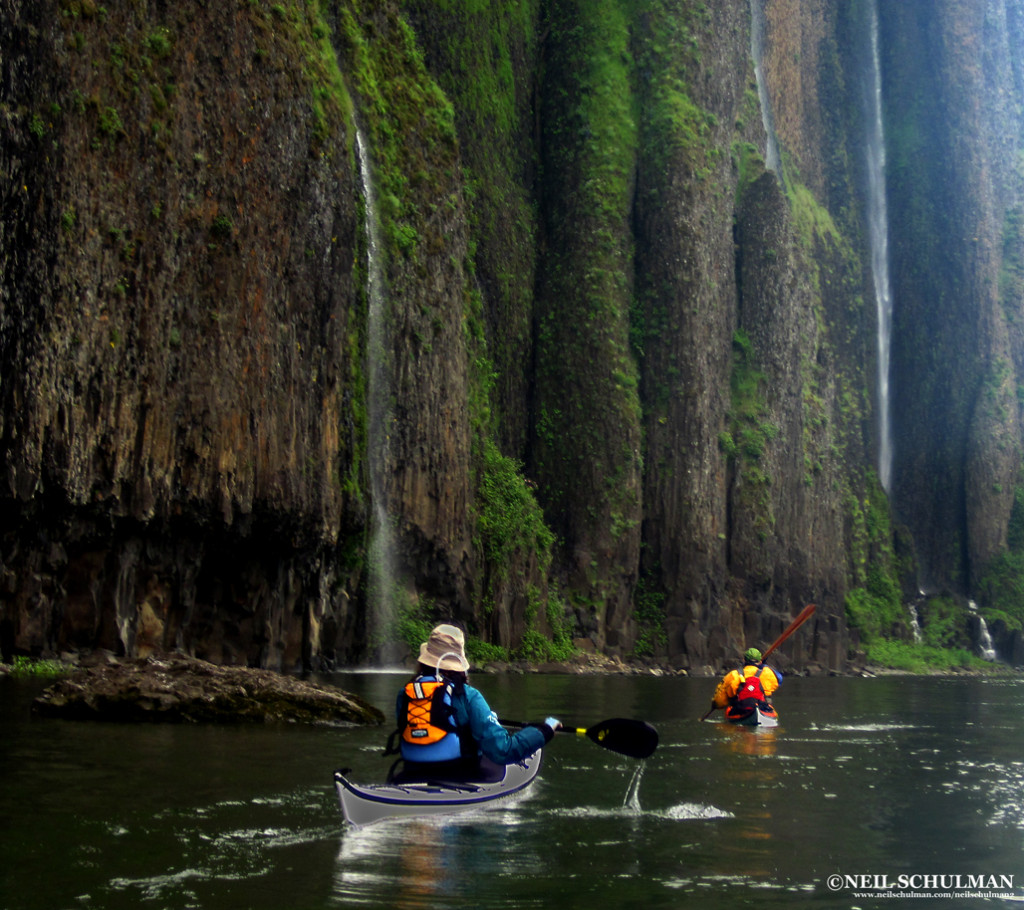
Paddlers beneath the waterfalls of Cape Horn in the rainforest at the western end of the Gorge

The High Desert Miller Island: (9 miles)

In the dry country East of the Dalles, Miller Island offers hiking as well as paddling. From the launch at Deschutes River State Park, circumnavigate the island clockwise: the north side, ominously named “Hellgate,” funnels westerlies.

Get out and hike to the top of the basalt cliffs that ring the island for stunning views of the Gorge and the island’s interior. In spring, you’ll see an array of wildflowers in bloom, including some found nowhere else in the world but the Gorge, which hosts a number of endemic plants.

The island was once a Native American village site for the many peoples that lived and traded along the Columbia River, such as the Wishram, Wasco, and Northern Paiute. Pictographs are visible from the water and along the cliffs. At the upstream end of the island, play in the wind and current eddies created by a series of rock islands, often under the watchful eye of several hundred Ring-billed gulls.

Continue around the island to Deschutes River State Park, or continue east to Maryhill State Park on the Washington side. The island is closed to camping, but camping is available at either Deschutes River or Maryhill.

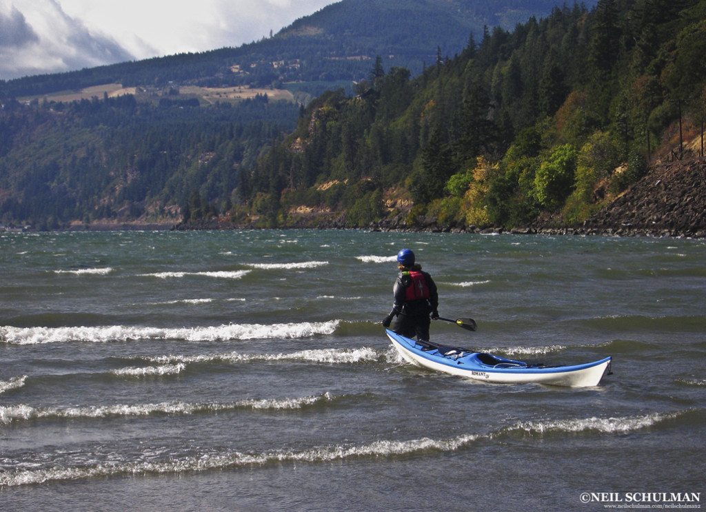
Jodi Wright launches into Force-4 winds near Hood River

Summer Downwinders

Windsurfers and kiteboarders have flocked to the Gorge for decades. The same factors that lured them—predictable wind, sunshine, and easy access—make it an ideal destination for sea kayakers to surf or to learn how to manage wind.

Gorge winds are caused by air pressure differences between the marine-influenced west end of the Gorge and the continental climate of the eastern end.

The eastern region is warmer from spring through fall, which creates lower air pressure compared to the cooler west. As air flows from high pressure to low, and the Gorge acts as an enormous funnel.

West winds strengthen and create bigger waves as they move east, so paddlers seeking more adrenaline should head toward Hood River or farther east. Kayakers seeking a milder day can paddle near Cascade Locks and Wind River, depending on the forecast.

Begin your downwinder by checking the forecast (see appendix) for several areas of the Gorge, and recheck conditions on the morning of your paddle. Look at the conditions before you set up your shuttle, and shift to a spot farther west if they look to intense.

Gorge wind strength is so localized it’s easy to match your skills by adjusting your paddle route to meet conditions. Expect westerlies to build during the day and ease around sunset.

My philosophy as a downwinder is simple: point downstream, surf, cackle with laughter, wash, rinse and repeat. Unlike surfing in the ocean, you won’t have to pound back out through the surf after each wave, get windows shaded by a wave closing out, or develop an embarrassing neck rash from neck gasket, sand, and saltwater.

When you want to surf again, just point downstream and go. If you miss a wave, there will be another one in a few seconds. When you need a rest, just float for a few minutes or work your way to shore and find a wind eddy.

Of course, every paddler has a different level of skill and comfort in wind. Wind below Force 3 is generally too small to surf; our group of skilled paddlers seeks wind in the Force 5 range (17-25 mph.)

Force 6 is exhilarating, but you’ll need to be on your game if anything goes wrong. In spring, strong current magnifies the wind-against-current dynamic and generates slightly larger sea states than the same wind conditions during summer.

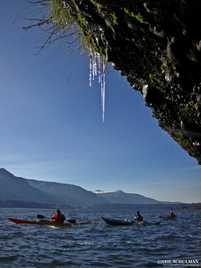
Icicles near Stevenson, WA on a cold day of the easterlies

Three Downwinders

Stevenson to Home Valley: 7 miles

Leave a shuttle car at Home Valley Park at the mouth of the Wind River, then launch at the public boat ramp in Stevenson, WA. The Washington shore is an intricate network of cliffs, coves and rock islands that provide breathtaking scenery and a good introduction to downwinders.

There are many nooks and crannies where you can rest, regroup, and practice turning upwind and downwind. In fall, spawning salmon in the Wind River put on an impressive showing.

Protect their spawning gravel by not walking in the shallows. After you shuttle back to Stevenson, walk down the block to Walking Man Brewing for a beer on the patio.

Viento State Park to Hood River (10 miles)

This run, located farther east, often has slightly stronger wind and larger waves on a westerly.  Leave a car at the Hood River City Marina, and then drive west and put in at Viento State Park ten miles to the west.

Start with a warm-up, paddle east (upwind) a quarter-mile to a large rock and group up in the wind eddy. Then cross to the Washington side and venture up the Little White Salmon River. Like the Wind River, it will be full of spawning salmon in the fall. Then surf upriver, crossing back to the Oregon side at the mouth of Hood River after passing its shallows, and take out at the city marina.

On this run you’ll encounter windsurfers and kiteboarders, and have a chance to play at the aptly-named Swell City. Then take your pick of Hood River’s many pubs where you can relax with a local brew.

Hood River to Mayer State Park (14 miles)

On this run, you’ll put in at the Hood River marina, follow several bends in the Columbia, and cross the mouth of the Klickitat River before ending at Mayer State Park. Wind is milder on the inside of the bends.

The lower Klickitat River is well worth a side trip to explore rock cliffs and oak woodlands, play in the river current, or watch for the local populaton of wild turkeys.  A half-mile upstream, paddlers reach the first set of riffles. I’ve spent entire days practicing ferries, eddy turns, peel outs, and upstream attainments here.

The Columbia pinches to its narrowest point between the mouth of the Klickitat and Mayer State Park, where waves are amplified as the accelerated current in this narrow passage meets the wind.

Save some energy to get your best surf rides of the day here, before heading for the Thirsty Woman Pub in Mosier.

The Easterlies

During winter, when the eastern high desert is colder than the temperate zone in the west, the entire Gorge wind factory runs in reverse. Colder air in the desert creates high pressure in the east and an east-to-west wind.  Just as a west wind creates waves in the east, an east wind creates waves in the western part of the Gorge.

On an day of easterly wind, the  aforementioned runs can all be paddled in reverse, from east to west: Home Valley to Stevenson, Hood River to Viento, Mayer to Hood River, etc. They will also reverse in difficulty: the further west, the stronger the wind and the rougher the conditions. The toughest conditions will be at Cape Horn, which is usually dead flat on a westerly. East wind flows with the current, which creates longer wavelengths for better surfing, but most east wind comes in the winter and is bone-chillingly cold.

Knowing the Wind

Windsurf-oriented smartphone apps such as iWindsurf, WindGuru, and NOAA weather are a boon for downwinders. They provide updates and forecasts, which make changing your itinerary easy as you head out to the Gorge.

The app can even send you updates when the conditions hit the perfect zone, so you can drop whatever else you’re doing to go paddle.

Downwinder Safety

Downwinders pose four particular safety issues: weather interpretation, wind management, group cohesion and sharing the river with windsurfers and kiteboarders.

Weather Interpretation

Humans are prone to exaggeration. Like the fish that got away, paddling stories tend to grow with the telling. In the Gorge, exaggeration can be dangerous.

I’ve heard many paddlers swear they were paddling in 35 mph winds, when I know for a fact it was really Force 4 (14-20 mph) from both my own measurements and the conditions report. This exaggeration leads them to honestly believe they have the skill to paddle in 35 mph winds, a recipe for biting off more than they can chew.

Learn to calibrate actual wind strengths with sea conditions and your paddling ability. Learn the Beaufort Scale, keep a paddling log, and refer to it when you’re wondering what 23 mph feels like.

Wind Management

You can’t control the wind, but you can control your boat in the wind. Turning your boat up and downwind and maintaining a course across the wind are basic skills for the Gorge.

Rudders and skegs help, but the paddler is the critical element. Learn to use paddle strokes and edging. You can lean forward and back, changing the trim of your kayak to make the wind help you turn. Grasping the effect of wind on a kayak requires experience in strong wind, which makes beginners nervous. Spend some time practicing these techniques with skilled paddlers in an onshore wind with a safe landing. When surfing, capsizes will happen.

Rolling in wind is much easier on the upwind side, and reentery and rolls often succeed because the paddler knows on which side they’re rolling. If someone does swim during a downwind run, there’s one major imperative: hold on to the deck lines. If the swimmer lets go, the empty kayak will quickly blow downwind while he or she stays in place, a challenging scenario for rescuers. In the warm water of summer, hypothermia usually isn’t a problem.

The east-wind runs of winter subject paddlers to more dangerous water temperatures.

Group Cohesion

Groups get easily scattered in the wind. Voices and whistles are often inaudible. Skilled surfers naturally speed ahead of more tentative paddlers, who are more likely to get in trouble.

One exception is during spring runoff with a westerly blowing, when skilled surfers tend to catch rides mid-current but make slow upriver progress while beginner paddlers who stay sheltered near the shoreline will get ahead of the rest of the surfers and remain easily visible.

In any case, a skilled paddler should stay upwind of (behind) the back of the group where they can see and respond quickly. Venturing out in the wind requires the same planning as any successful trip in challenging water.

Make plans for if the group gets separated, plan bailouts, map points for reassessment, maintain VHF communication and conduct an accurate assessment of skills.

Windsurfers & Kiteboarders

Paddling the Gorge means sharing the river with windsurfers and kiteboarders. While it can be unnerving at first, paddling with windsurfers is safe as long as they know you’re there.

Windsurfers tend to move predictably back and forth across the wind, while kayakers usually paddle downwind. That means they’ll be looking at the wide side of a kayak and they will spot a group easily. Windsurfers usually have a lot of control and can avoid you as long as you maintain a course.

Kiteboarders are connected to their kite by a cable, and I give them a wider berth to avoid the cable. Since the kite has more surface area and is higher aloft than a sail, they’re often slightly less predictable, though they tend to be on the river in lower winds than windsurfers.

I avoid the Hood River shallows because it’s popular with beginner boarders who have less control.

Now, back to my fun on a summer day in the Gorge. We ate up the miles until our smiles were exhausted. We found a sheltered cove along the northern shore for lunch.

While we ate and filled up our Tupperware with local blackberries, we watched six-person Hawaiian-style outrigger canoes fly downwind, training for an annual race through the Gorge. Later, we shared a pub with the racers and marveled again at how few sea kayakers paddle in the Gorge. It’s been overlooked for far too long.

Neil Schulman is a Portland-based photographer and writer. In his spare time, he also teaches kayaking and does environmental work. You can see his writing and photography at www.neilschulman.com/neilschulman2

Appendix:
Columbia Gorge Weather forecasts:
Weather.gov

Smartphone Apps:

iWindsurf
Windfinder

Sometimes you eat the gator. Other times, the gator eats your kayak.

Innova Kayaks, manufacturers of the inflatable Swing kayak (pictured above), received an interesting email, along with these photos, which read:

You may have seen the news stories across the nation since Saturday. I had incident with gator.

I wanted to thank you because as far as I’m concerned, being in an inflatable saved me from potential injury. I think if a gator had hit a hard shell kayak with as much force as it hit my Swing, I would have been tipped into water.

As it was, the other 2 air chambers stayed completely inflated and after the darn gator was done chewing and spinning around with its mouth full of deflated rubber, I was able to paddle quite a distance away and call for help.
Will miss my little yak, was fun for the month that I had it!

Thank you again.

Sea Kayaker has been informed that Innova, in cooperation with Adventure Times, the retailer where Sarah purchased her Innova Swing, will be replacing the partially eaten boat despite the fact that attacks by carnivorous predators are not covered under warranty. Sea Kayaker hopes to offer its support by sending her an alligator skin PFD… as soon as we find a manufacturer.

Last stop on the Nordic Tour with Helen Wilson and Mark Tozer

Our last week in Sweden was very busy. After leaving Nynashamn, we made our way to Sandhamn. Sandhamn is a gorgeous island just east of Stockholm. It can only be accessed by boat. John Sjoberg of Sandhamns Kajakskola picked us up and took us to the island, which has a very relaxed feel. The small harbor area hosts a couple of pubs and restaurants. The following day we conducted a rolling class in the morning, and a strokes class in the afternoon. During the strokes class we wound our way around several of the islands in the archipelago enjoying the gorgeous scenery.

The ride to Sandhamn.

Although Sandhamn is very close to Stockholm, it feels secluded.

Mark talks about the forward stroke.

This sandy island was a great place to stop for coffee and cinnamon rolls.

The archipelago can be very tranquil when the weather is calm.

The following day, John returned us to the mainland and we prepared for classes in Sickla that would take place in the morning. Although in distance, Sickla is not far from Sandhamn, it has busier feel, as it is very close to Stockholm’s center. Classes took place through Sjostaden Kajak. Mark and I conducted two rolling classes and a rescue class, all of which took place on a small lake that is part of a chain of lakes that run through the area.

The paddle to the lake was very pretty with lily pads lining the narrow channel.

Rolling felt great in the warm lake.

Mark demonstrates how to empty a kayak before performing a self rescue.

After teaching in Sickla, we made our way across Sweden for our last stop on the west coast. We arrived in Helsingborg and were greeted by Zsuzsanna, a lively and fun woman who organized our visit to Helsingborgs Kanotisterna. Upon arrival I was happy to realize that I’d been there during the first year of the Nordic Tour in 2010. I recognized the club and the active beach, which had lots of organized recreational activities for people to enjoy. The first day we taught two rolling classes, and the second day was filled with strokes, maneuvers and rescues in the harbor area.

Helsingborg has a wonderful sandy beach, with great views of Denmark in the distance.

Strong winds and cloudy skies created a dramatic backdrop for Sunday’s classes.

Demonstrations and activities on the dock provided a break from being on the water.

After leaving Helsingborg, we crossed the country one last time to return to Stockholm for our final day of classes before flying home. We met up with Karin and Martin of Ornsbergs Kanotsallskap. The following day we conducted a yoga session and a rolling class on another of Stockholm’s gorgeous lakes. We enjoyed hanging out with Karin and Martin in the evening and learning all about the beautiful city where they live.

The kayak club is right on the water.

Paddle tricks provided a fun after lunch warm up.

We’re now back home, and this year’s tour is over. Thank you to everyone who helped organize it, and to all of the participants who came out to take classes from us. We’re in the process of organizing next year’s tour, and hope to see you all again!

Safety: Storm on Yellowstone Lake

I woke up in the front seat of my truck on Sunday morning at the Grant Village parking lot on the shore of Yellowstone Lake. Despite my penchant for making lists, I’d forgotten a couple of things, so I bought some Tang for breakfast and a hoodie in case it got cool.

I had breakfast in the restaurant by the boat ramp and went to the backcountry office for my boating permit and campsite reservations. The guy there looked at my itinerary and mentioned that I had a 20-mile passage and some long days between proposed campsites. Then he said that they don’t recommend traveling alone.

I asked, “Do you want to come with me?” He laughed and shook his head. Then he told me to stick close to shore, but the look on his face told me he knew that I wouldn’t. Of course in rough weather I would stay close to shore, if I went out at all, but with a favorable weather report and no clouds in the sky, I’d cut across the bays. The Park Service does a great job keeping people safe, but they know to let the more experienced boaters do their own risk evaluations.

My trip was going to cover the south end of the lake. The north end has a highway that runs along it—I didn’t go to Yellowstone for traffic noise. Besides, that’s the open part of the lake and weather can whip up quickly with a fair amount of force. I prefer the more convoluted path at the south end and the anticipation of what lies unseen around the next bend.

Yellowstone Lake is the largest lake above 7,000 feet in North America. It has 110 miles of shoreline and an average depth of 139 feet with a maximum depth of 390 feet. Half of it lies in the Yellowstone Caldera, an ancient volcanic crater approximately 34 miles wide and 45 miles long. The super volcano that created it erupted on three occasions, 2.1 million, 1.3 million and 640,000 years ago.

Sunday’s weather was perfect with barely a breeze. I cut across the West Thumb, a 3 ¾-mile-wide lobe of the lake on its western side, and paddled through the narrows to the main body of the lake. After 12.3 miles I reached my first campsite at the mouth of Flat Mountain Arm. Halfway there, I realized that I had forgotten one other thing. Bread!

I had scratched it off my packing list when I bought two loaves, only to leave them in my fridge. My sandwiches would be rolled-up ham and cheese and there would be no toast with breakfast.

At the campsite I had the option to place my tent on a slight, flat-topped hill overlooking the lake, or down by the shore. I chose the shore to be closer to water for cooking. Each park-maintained campsite has a fire pit. After I set up my tent, sleeping bag and pad, I got back in the boat to paddle the Flat Mountain Arm.

What little wind there was had died, and the lake was like a mirror reflecting the beautiful pine-covered mountains. I was told that the campsites at this end of the arm were not open because of the presence of bears at this time of year. I hoped to catch sight of one taking a drink from the lake, but I saw none. At the end of a six-mile loop I was back at the camp.

The following morning, I packed up, paddled across the mouth of Flat Mountain Arm and crossed over to the South Arm and headed south. At the end of the arm, as I paddled between two islands, a pair of eagles came swooping down, trying to hook talons in a courtship ritual. They missed.

The fire of 1988 was evident in many places. Tree skeletons, no more than bare trunks, rose far above the eight- to 10-foot-tall post-fire pines that were replacing them. The park  is making a remarkable recovery.

Coming back north on the east side of the arm, I found my second campsite. It had a sand beach that wrapped completely around the point, leaving me with lots of sun and a view of the entire South Arm. The fire pit and camping area was up on a small rise. After a bit of lunch, I went for a swim. The water was a bit chilly, but it was another perfect day in the 80s with blue skies and only a few white puffy clouds. My day’s mileage was 15.7.

My third day of paddling was going to be a short one, less than 10 miles, so I slept in and made a late start. I paddled up the South Arm, rounded the point and back down the Southeast Arm. Shortly after rounding the point I passed a beautiful campsite, but I continued on to where I had made a reservation. At the bottom of the arm, the lake widened and I found  my campsite.

It was off to the side with a long, tree-lined outcropping, creating a small protected bay. It was next to a huge open meadow with lots of purple, yellow and red flowers and a thick forested area with a fire pit and room for a tent. I had my choice of sun or shade, but I was concerned that the meadow would attract bears seeking berries.

Later that evening, I finished my dinner of chili and had pudding for dessert. As the sun went down, I crawled into my tent to read the issue of Sea Kayaker that I’d packed. About an hour later, I heard the sound of a thick branch cracking. The last time I’d heard that noise I was in the Minnesota Boundary Waters—and it had been a bear. Grabbing my can of bear spray, I began to consider my options.

I didn’t want to leave a tent door open for a quick exit because of the mosquitoes. With a two-door tent, I could go out either way. I hoped I wouldn’t have to spray a bear while I was inside the tent. Ten minutes went by and nothing—then another loud crack and again it was quiet. Suddenly, I heard another crack; but this one was much louder and the sound kept going until I heard a very loud thud.

It was unmistakably the sound of a falling tree—but there was no wind. I was afraid that it was a bear pushing over one of the dead ones. The bear I saw in Minnesota had torn a tree stump apart to get at some ants. I heard nothing after that and later went to sleep. As I drifted off, it occurred to me that this was the first time I had ever known of a tree falling without it being cut down. I figured that I would likely never experience that again.

The next morning brought the first sign of a change in the weather. It was cloudy, but the sun was trying to peek through. After breakfast, I packed the kayak. On days like this, I leave the tent for last in case it starts to rain. It did. I crawled back into the now empty tent and waited. Ten minutes later it stopped, and I was on my way.

I headed across the bay, avoiding the Molly Islands bird sanctuary. When I got to the other side of the arm, I found a small river. I paddled up a ways, but I didn’t want to make this a long day because the next day I’d have to paddle close to 20 miles and cross some open water to get back to my truck—even longer if weather forced me to hang closer to shore.

I wanted to make that crossing as quickly as possible because you never know what the weather on Yellowstone Lake has in store for you, and I didn’t want to get caught out in the open. As I headed back out onto the arm, I saw a rain cloud moving toward me from across the lake.

A giant, thick bolt of bacon-strip lightning crashed down to earth. I thought about continuing but, reminding myself of the many foolish risks I’d taken in the past, I pulled over to the shore and exited the boat. The wind and the rain soon came.

It didn’t rain hard or long, but the wind was strong. I retreated to the cover of some tall, thick bushes and stayed dry and out of the wind. The waves kicked up and although they weren’t very big, I was glad not to be out there. A half hour later, the wind died. The lake was still choppy, but not bad, so again I
pushed off.

The waves turned to gentle swells coming from my left, but then the wind did a 180-degree shift and created small waves from my right. This made for a slightly confused sea, but I was more annoyed than worried. I would soon exit the wide area of the lower part of the arm and be in a lee of the land with only the gentle swells to contend.

As I made my way up the arm on the east side, the wind switched again and came from the south. The wind waves grew large enough to surf. This made the going fun and easier.

Then the wind picked up and the waves got up to two-feet high. I decided to cut across the arm hoping that the other side would be calmer. The change in plans would also allow me to stay at that beautiful campsite I’d passed near the point and cut off a couple of miles from my last day’s paddle.

The only downside was leaving the safety of the shore for a 2.2-mile open-water crossing. However, I could easily see the waves coming from my left and I could turn into the larger ones. It would be no problem if it didn’t get worse. It got worse.

The wind increased and the waves grew to 2½ to 3 feet high. The rough sea made my paddling more difficult; what should have taken 30 minutes took almost an hour, and I was getting tired. Near the other side, I discovered the land wasn’t protecting me at all.

The waves were going right down the coast, so I turned north and paddled slowly, letting the waves slide under me. With just 50 yards left to get to the campsite, the wind died as quickly as it came. By the time I turned around the point and beached my kayak, the water was completely flat.

I saw I had cell phone reception and called the backcountry office to let them know of my change of plans. They assured me that the site was available and thanked me for calling.

I made some soup for dinner and put up my tent. As evening came, I saw a storm cloud coming across the lake.

The first storm had come from the west, the second from the east and the third from the south. This one was coming from the north. As the storm approached, I could only see the edge of it. The rest was concealed by the trees on my left. Not recognizing the size of the front moving in, I thought, “At least this will be a mild one.”

I went to my tent early and within a few minutes the winds whipped up. I switched on my VHF radio and listened to the forecast: “Severe storms expected. If you see one of these storms approaching, move to a sturdy building immediately.”

I’d never heard that kind of advice on the weather radio. I laughed. What was I supposed to do? I’d been in some nasty blows, but I’d never heard such a warning before. The forecast was for winds stronger than anything I’d experienced, so I decided it would be wise to evaulate where I was and consider picking a safer spot.

There were fallen trees all over this part of Yellowstone. I had little idea which of those still standing were vulnerable to being toppled. A friend of mine told me that he was in a storm and only the live trees got blown over because they had plenty of leaves to catch the wind; the dead ones were bare and stood strong.

In Yellowstone, there are lots of dead trees from the 1988 fire. With that tree crashing down not far from me during the windless night before, I should have been more aware.

In addition to the countless fire-damaged trees around me, trees throughout much of the west have been damaged by beetle infestation. Many campsites have been closed until they can be cut down. Setting up my tent next to a downed tree might offer some protection, I thought.

I left my kayak tied to a log close to the water’s edge. I hung much of my food from a tree, but my kayak was still quite heavy, laden with cans of food. I was betting a bear couldn’t smell through metal.

[Not a winning wager. According to the National Park Service, bears can pick up scents from metal cans. See www.sierrawild.gov/bears/faq —Ed.]. I loaded them separately—rather than packed in bags—for better weight distribution, a tighter load and more storage. As a consequence, it’s inconvenient, though usually unnecessary, to unload my supplies.

A lot of it stays in my kayak when I’m in camp. I’ve been in some severe blows before that were so strong the tent completely blew over flat across my face, but my kayak, weighed down with the gear aboard it, didn’t budge. It was only after this trip that I realized the log it was tied to could have been washed away.

If I’d had more rope, I could have, if nothing else, tied my kayak to something solidly fixed on higher ground. There was the rope that I’d used to tie my food up in the tree—there wasn’t much chance of a bear foraging for a meal in that storm—but I didn’t think to repurpose it.

So, upon hearing the weather report, my attention was focused on what might happen to me in the tent, rather than on the vulnerability of my kayak.

The wind seemed to double in strength every 30 seconds. Soon, dirt was flying up under my tent’s fly, through the screen and onto the book I was trying to read.

The wind kept building, and I became concerned. Suddenly, that cracking sound that I’d heard at the last campsite came again, only this time much louder and much closer. With a powerful thud the tree came crashing down onto the corner of my tent, missing my foot by inches. The roof was pulled down slightly and it was difficult to unzip the screen door with its distorted shape.

A branch tore off another tree and landed right next to the tent on the other side. As I stuck my head out, thick branches blocked my way. A huge tree trunk pressed up against the side wall. I realized how close I’d come to injury or even death. I crawled out of the now small door opening and looked out onto the lake in absolute horror. There were five- and six-foot waves with the wind blasting the tops off into spray.

If I had gone with my first idea of paddling farther, I’d still be out on the lake. There was no way I could paddle in that maelstrom. It was then that I began to worry about my boat. It started to rain.

I crawled back into the tent to keep dry while I figured things out. The tree had landed on my can of bear spray. I wondered what would have happened if that thing had exploded with me in the tent. Just then, another tree crashed to the ground about 10 feet from me.

Luckily, it was downwind of the tent and fell away from me. I stuck my head out to see the damage and then I looked upwind. I saw four tall trees within striking distance. There wasn’t one live pine needle on any of the four trees. They were dead and had been decaying for 24 years since the fire. I couldn’t stay in the tent, and I also couldn’t move it because it was pinned under the
fallen tree.

My mind raced. If I had to abandon the tent, I’d have to find something to shelter myself. The only waterproof thing in my tent was my sleeping pad. My concern about leaving my shelter was hypothermia. Soaking wet in a 40-degree night could be serious.

I said to myself, “Think, Jim, think. What do you have? Where’s your stuff?” Even though I’d heard the warning on my VHF,  I had negelected to bring enough “just in case” stuff to my tent.

I had nothing to protect me from the rain. I’d thought that as long as I was in the tent, it wasn’t going to be blown away, and I could weather the storm safe and dry inside. I never foresaw myself stuck outside my tent hoping trees wouldn’t kill me.

I calmed myself and remembered that my rain jacket was in my kayak. I needed to check on my boat anyway, so I hurried to the shore. It was fine, but it had been blown sideways by the wind.

I pulled it as far away from the water as I could. I grabbed my multi-tool and jacket and ran back to the tent. Wind and rain sprayed my face as I knelt in the lee of the tent, staring up at these four giants and waiting to hear that awful cracking sound.

I was forced to stay outside the tent to keep an eye on the trees, but could I get my 60-year-old self out of the way in time? I looked around, but saw nothing that could give me any sort of shelter from rain or wind. I had to figure something out.

Then I saw the logs that were used for seating around the campsite fire pit. I grabbed a log and laid it next to my tent then I grabbed another and placed it across the first. I laced more logs across each other making a V-shaped wall up in front of my tent. If those trees came down, they’d crash onto the logs instead of me.

My fortress complete, I crawled back into my tent and lay down on the side closest to the wall of logs. Adrenaline was still flowing through my veins, but I was feeling safer now and I began to calm down. I heard two more trees come crashing down, but not the ones upwind of me. About 45 minutes later, the winds began to subside and I was able to drift off to sleep.

Dawn revealed a perfectly calm day with no wind, glass like water and blue skies. I got up and inspected the damage. The tent was still pinned under the tree and it wouldn’t budge. I decided to give myself time to figure this out while I went to see if I still had a boat. I found it upside down with its rear deck shoved up on some rocks.

My spray skirt and paddle leash had kept everything with the kayak, including my two carbon wing paddles. There was almost no damage to the kayak, just a few chips in the gelcoat. My expedition deck bag was gone. In it were my two cameras, binoculars in a waterproof case and a few more belongings like my toilet paper.

I looked around, and to my amazement found the deck bag washed up about 10 yards down the beach. Then I looked at my PFD and realized that in all that had happened, I’d never even thought about my PLB in the front pocket. Not that I would have needed to use it, but that’s not something you want to forget about in an emergency. If I had been pinned under a tree, I could have used it to signal for help. All that I lost from my boat were my cheap $10 sunglasses.

I returned to my tent. I looked at the pile of logs and thought I could use them to create a fulcrum and lever to move the tree off my tent. The idea worked. I pulled the tent free. I was surprised that there was no damage to either the fabric or the pole.

I was still shaken and thought to wolf down an energy bar and race across the lake back to Grant Village. Instead, I reconsidered and had an oatmeal breakfast and some orange juice and settled myself down before heading out. After a relaxed 19 miles of paddling I was back at my truck.

When I got home, I called the National Weather Service and asked what the highest wind speed was on Yellowstone Lake that night. The highest recorded wind was 87 mph, but she said it could have been higher because some of the weather stations hadn’t reported. I asked, “How come? Did they get blown away?” She said, “They might have.”

Jim McCann lives in Colorado and kayaks about 75 times a year on mountain lakes. He’s been at it for almost seven years. Before that, he was a canoeist for five years.

Lessons Learned

I lived in Yellowstone Park for six years in the ’90s and have paddled on Yellowstone Lake many times over the past 35 years, so I have come to know it quite well. In addition, I have come to respect it. Jim describes paddling on Yellowstone Lake with accuracy and detail.

It is, indeed, a very large body of very cold water where intense winds can develop quickly without predictability. Conditions can range from glassy surfaces to waves that would challenge and bring fear into the heart of even the most experienced paddler.

It is a mistake to paddle on Yellowstone Lake without being mentally and physically prepared for every possibility. When we leave land for water, even inland lakes, we have taken on significant additional risks.

Having said that, not every condition and possibility can be known, prevented or planned for.

There are always changing conditions and surprises that we must respond and react to. This is certainly part of the reason we find enjoyment in paddling our little boats to remote places.  The unknown challenges that lie ahead do pull us along.  It is clear to me that this paddler feels that pull, and I admire him for it.

The National Park Service does an excellent job of trying to prepare visitors for the realities of paddling on Yellowstone’s waters and for traveling into its backcountry.

I have listened to their checklist of warnings many times, and there have been times when I felt as if I knew more than the ranger. That can be a mistake, as the 100-plus deaths on Yellowstone’s waters attest to. Being humbled can be a good thing.

Complacency on Yellowstone Lake is not. The tendency to get going, to prove things, to power on can often overwhelm our deeper instincts, gut feelings and good sense—all qualities that can help keep us safe. Mindset is an important element in big-water paddling.

Heading off alone into backcountry of any kind also adds to the inherent risks, and the Park Service is correct in the warnings given to solo paddlers. I have had some of my most memorable and enjoyable trips with no one to share them with but myself.

However, it should be obvious that one’s risks go up when traveling alone on water in the backcountry, and one should behave accordingly by being hyperalert to possible dangers.

With all the warnings the Park Service outlines, one can’t be warned of every possible risk, and it is not clear to me whether the paddler was warned of falling trees.

I can’t recall that I’ve ever been warned of “widow makers.” It appears to me, however, that the park does make an effort to cut down limbs or entire trees that may pose a risk at campsites.

As I read Jim’s narrative, there were a couple of red flags at the start of his trip. He had forgotten warm layers when going into the high-mountain, cold-water conditions of Yellowstone Lake.

Substituting a good synthetic layer with a gift-store hoodie, most likely made of cotton, is not the ideal—as I trust he knew. Also, forgetting somewhat important food items made me wonder a bit at Jim’s method of preparing for a trip.

No matter how many trips you’ve been on, there are a lot of things to remember, and to forget things is natural. Relying in any part on your memory when preparing is inviting omissions. The creation of a personalized and detailed checklist of equipment is essential to the safety and enjoyment of your trip; though even Jim, with a “penchant for making lists,” prematurely checked off “bread” and forgot it in the fridge.

Make sure you’re constantly updating your checklist and don’t ignore any item until you’ve put it in your boat. From my own mistakes, I know it’s not unusual to bring a necessary item to put in, only to leave it in the vehicle. While paddling in Alaska’s Glacier Bay National Park, I came across a couple who had experienced several miserable nights in the rain, hunkered down in a tent without poles which were left at the launch.

So, use your list when preparing and packing for the trip, double-check it at the launch point, and update it both during the trip and shortly after. Updating it after will help you benefit from your experience by eliminating the items that turned out to be superfluous, and adding new ones that will improve your next adventure.

An equipment list should be continually revised. This list can also include such additional items as: Have you left your float plan with someone? Is your mail being taken care of?

Have you checked weather forecasts? Is your vehicle locked and do you know where the key is stored? Your wallet? In other words, your list should address every detail so you can relax knowing you are completely prepared.

When you are traveling in a group, be sure to double-check the items others are responsible for both at home and again before launching. You don’t want to be at camp the first night and find out the food, the stove and pots, or the tent poles are still at home.

It does appear clear that Jim used adequate caution in assessing the water conditions, thereby arriving safely and without incident at each of his camps. Though luck sometimes plays into our successful outcomes more than we care to admit. Ironically, terra firma was where his risks increased to a dangerous degree—and this can so often be the case.

There’s a strong tendency after a long day of paddling, perhaps out of relief or weariness, to just get camp set up, get some food in our stomachs and sit back and relax. It may simply have to do with the security of being firmly ashore. The risks are over. Or are they?

At times I’ve paddled in some challenging conditions, whether on the coasts of British Columbia and Alaska or on a big freshwater lake like Yellowstone, where the last thing I did was consider my safety.

For example, even on land, winds can be a problem and, in some cases, even life-threatening. Gear and boats can be blown away, leaving you in a precarious situation at best. While canoeing in the Boundary Waters region in Minnesota, my paddling partner and I were forced to camp on a small and exposed island due to increasing wind and waves.

Once camp was set up and we felt relatively secure hunkered down in the tent, the wind really picked up, blew cooking gear into the lake and rolled our 18.5-foot canoe well into the island. The lost pot was a nuisance, but what if the wind had blown the canoe toward the water rather than inland? Should we have tied it down even if it was high and dry? Most certainly!

While that remote island we were forced to bivouac on was treeless, trees would have surely added to the risks.

It turned out this storm was one of those that flattens square miles of trees like stalks of corn, complicating camps and portages for the remainder of the trip.

Camp is where new risks replace the ones left behind on the water, and these deserve the same degree of attention. Camp becomes the place where burns and cuts can occur, where ankles and knees get sprained, where contact with wildlife takes place, where rocks can tumble from cliffs and where trees can fall. Dead trees combined with high winds was exactly the very serious situation Jim found himself in. Could he have eliminated the risks? That’s hard to say, but there are some things he could have considered that may have
reduced the danger.

As Jim describes, parts of the Yellowstone Lake region were burned in 1988. That’s a long time ago, and most of those dead trees have fallen over the years. But some remain standing, and you can be assured that their root systems have decayed, leaving them poised to fall when the wind comes up.

Weather reports that include high winds should always be cause for evaluating your situation and taking steps to assure your safety and secure your gear.

While forecasts will help you assess general and potential risk, alertness to specific conditions at your location is what can save your life. How strong are the winds, what direction are they coming from, how are my camp and my tent situated within this reality and, in the context of this article, are there trees nearby (or limbs overhead) that could pose a threat?

Moving camp can be an option, but it’s not always a realistic one. In Yellowstone, you may only use a site if you’ve reserved it. Of course, I can’t imagine the Park Service would quibble over a camper’s decision to avoid an apparent risk.

(I once had a family ask to share my camp on Yellowstone due to inclement weather and, of course, I made room for them.) If there’s a safer spot to pitch your tent, that’s an option to consider.

Jim had already made his camp and retired for his third night when he heard a cracking branch that caused some concern. I’m puzzled that the cracking and thud of a falling tree came without wind and a flapping tent, or the sound of waves coming ashore.

I have to wonder whether the absence of wind was in the primitive realm of nighttime imagination that we naturally carry with us. But sometimes trees do fall of their own accord, and maybe this was one of
those times.

At this point, it would have been both wise and helpful to exit the tent and take a look around with a flashlight (and his bear spray—just in case) to assess the situation and conditions. While I can understand the hesitation to exit a tent when bears are in our thoughts, especially at night when our fears may be distorted, a tent provides no real safety if a bear is present.

If it was determined that conditions were worsening, he could begin to assess the risks and his options. Whether or not the weather was responsible for the tree falling, a tree did indeed fall. That’s cause for concern, and some action.

The following day’s lightning, rain and wind brought some changing conditions that Jim responded to by wisely heading to shore to wait it out. As he headed off again, conditions on the water may have been fun, but also noteworthy if waves were getting to two feet.

A crossing of over two miles with these changing conditions, in my mind, is taking an unnecessary risk—one that increases as the paddler tires. While weather systems passing through the region may have somewhat predictable conditions, the uncertainty and possibility of localized strong winds and high waves should be taken seriously.

Many people have died of drowning and/or hypothermia on Yellowstone Lake after their watercraft capsized on open-water crossings during both predicted and unpredicted afternoon storms. Jim was lucky he made it through the deteriorating conditions to a beautiful, albeit unplanned camp.

Jim used his cell phone to call to the backcountry office to inform them of his changed plan. That was the right thing to do, and one of the many benefits of today’s technologies. Jim was also equipped with a VHF radio, and the weather report he describes was an ample warning of things to come. With that warning Jim should have secured his camp, the kayak and its contents.

This should have been part of the preparation for the upcoming storm, not done after the fact. When we are on the water during deteriorating conditions, the increasing dangers cause us to seek safety by getting ashore or to a protected place, but when the same conditions take place on land, we are often lulled into complacency by the apparent safety of land, only to find different risks and dangers looming all around us.

This was therefore the time to assess the risks of falling trees, especially since this had happened the night before. Conditions were becoming ripe for this and sure enough, soon after, a falling tree came close enough to raise the greatest of concerns, losing one’s life. Then a second tree came down. His situation was worsening, but the risks to his well-being could have been lessened by assessing them ahead of time. The time to notice four dead trees directly upwind is before a storm hits, not in the midst of it.

Under the seriously deteriorating weather conditions, Jim ultimately jumped into action, attending to his boat—but not securing it—and trying to remedy the pinned tent situation. Hypothermia was a realistic concern, especially considering the hoodie layer and the fact that his rain gear was not with him in the tent, but left in his kayak.

Building the protective log fortress was probably better than nothing, especially under the circumstances, but I would be suspicious that logs light enough to be moved by hand wouldn’t offer adequate protection from the extreme force of a falling tree.

The new day brought clearer weather and perhaps a clearer mind. Jim was very fortunate that his kayak was still there and undamaged. Wondering and worrying about its safety could have been eliminated if he had properly secured it earlier.

Getting a good night’s sleep is always important. It helps you recover from the rigors of the previous day and better prepares you for the day to come. A restful night is more likely if you prepare for the worst before turning in.

For a calm and confident mind, make sure that your kayak is safe and secure, that gear won’t blow away, that food has been properly stowed and that emergency and rain gear is at hand.

Jim was fortunate; he came away from a severe storm—with perhaps record-breaking winds—with minimal material losses. It could have been far worse. Could he have prevented the worst-case scenario?

That’s difficult to determine, but I hope his story now promotes a greater understanding and respect for the forces of nature and the risks they impose. Look up, down and all around whether you’re on water or land.

Don Nelson has been kayaking since 1993 and lived in Yellowstone Park from 1991-1997 as the Director of the Yellowstone Institute. He is the author of Paddling Yellowstone and Grand Teton National Parks.

Kayaking, camping, traditional island life and an international border

Our kayaks were lined up like driftwood along the sand and stone beach when we heard the long, sharp Miller Ferry whistle in the distance. The sound welcomed the beginning of another trip to the Erie Islands and our launch from the Ohio mainland for a three-day weekend of paddling among the largest collection of islands on Lake Erie.

Located in the western basin of Lake Erie, the Bass Islands and their surrounding sister islands are part of a 21-island archipelago located in some of the richest walleye fisheries in the world.

While well known as a sport -fishing destination, the islands also offer some of the best paddling opportunities on Lake Erie. The island chain, separated midway by the international border with Canada, is steeped in history from its roots as a Native American fishing grounds to its grape -growing heritage and its pivotal naval battles during the war of 1812.

You can make the easy crossing from Catawba Island to the campground at South Bass Island State Park from several mainland locations. There is a public beach launch location just east of the Miller Ferry dock and another at Catawba Island State Park.

To add a few more shoreline miles, you can put in further southeast at the Mazurik public boat launch near Marblehead, Ohio. The three-mile crossing to South Bass Island takes kayakers across a busy boat and ferry channel, but be attentive and respectful and you should have no problem negotiating vessel traffic. Give a wide berth to the active ferries serving the island.

We edged our boats into the water from the little beach east of the Miller Ferry and paddled past Mouse Island toward the southern tip of South Bass Island, where its lighthouse greets boaters coming from the mainland. For the many day-trip opportunities in the Bass Islands, paddlers usually split off before the light and head east or west toward their selected adventures.

I prefer to paddle west around the rocky coast to South Bass Island State Park and set a base camp, then day-paddle throughout the islands for a nice, long paddle weekend. When you visit the islands for the first time, it’s easy to spend four or five days linking multiple island crossings and shoreline for more than 40 miles of water. Paddlers looking for a three-day weekend getaway or more can find many interesting shore and historical sights among the islands.

South Bass Island State Park offers cliff-side campsites reserved for tent campers, and the vistas overlooking the lake are a perfect post-paddle reward. These sites sit more than 100 feet above the water and you can set your tent as close to the lip as you dare for maximum viewing pleasure.

It’s only a short carry from the beach to the closest sites but we typically leave our boats lined up on the grass above the rocky beach and lug the gear up the slope to camp. The small harbor and breakwall off the beach provides a great location to practice rolls and rescues when the wind cooperates.

On previous trips, we always seemed to draw a small crowd of spectators who enjoyed watching us turn upside down and sideways during practice. On this trip we planned to put some miles behind us, so we launched our boats over the cobblestone beach for the afternoon paddle into the island’s main harbor.

All of the islands in the chain are limestone bedrock and paddlers usually follow the steep cliffs from camp four miles around the northwest shore to the harbor village of Put-in-Bay.

Cottages dot the cliffs above the water along this section. From a kayak you get a unique perspective of Benson Ford’s Shiphouse, a freighter which was removed and craned to the cliffs as a summer home in 1986.

At water level, the broken shoreline leads paddlers through a playground of rock gardens that dot the base of the cliffs. Depending on lake levels and wave action, there are several carved out caves where you can poke your kayak and many dynamic rocky play areas.

Paddling into Put-in-Bay Harbour, you’ll wind through sailboats bobbing at mooring balls and water shuttles bringing boaters into the busy maritime village. The little rocky beach at the edge of DeRivera Park, next to the Boardwalk restaurant, makes a convenient rest stop.

Stretching your legs, you’ll peer over the breakwall and back into time at the village’s nautical-themed, gingerbread framed shops that face the waterfront and park. This destination offers a convenient option for paddlers; they can rough it at the state park camp or wander into town for a beverage, perch dinner and nightlife.

Gibraltar Island and its steep, rocky shoreline is a paddling gem that guards the harbor entrance.

It’s home to college research laboratories instrumental in tracking lake biology and preserving the rare and threatened Lake Erie water snake. From time to time Stone Laboratory, the oldest freshwater biological field station in the United States, hosts open houses for visitors interested in learning about the ecology and biology of the lake.

The Stone Laboratory anchors one end of the island and Cook Castle sits high on the cliffs at the other end. Paddlers can also stop at the joint Ohio State University and Ohio Department of Natural Resources (ODNR) outreach facility across the harbor at Peach Orchard Point. Exploring the waters around Gibraltar Island, you’ll wind your way around car-sized boulders and under rocky overhangs that block out the surrounding boat traffic.

The highlight of your Gibralter circumnavigation will be finding Lake Erie’s only natural sea arch, the Needles Eye. Threading the needle is a paddler’s tradition.

As you head east out of the harbor from Gibraltar Island you’ll also be in the shadow of one of the most impressive sights on Lake Erie: Perry’s Victory and International Peace Memorial.

This fluted, granite Doric column, topped with an observation deck, stands 352 feet (47 feet taller than the Statue of Liberty) above the island and symbolizes the long-lasting peace between Britain, Canada and the United States. On a clear day the observation deck provides views of the entire western basin, islands and Canada. During the summer of 1813, Commodore Oliver Hazard Perry sailed from Put-in-Bay Harbour to fight the British in a battle that would help close out the War of 1812. Perry commandeered the Brig Niagara after his original boat, the Lawrence, was disabled.

With the Brig Niagara, Perry proceeded to outflank the British on his way to U.S. Naval victory. Vessels around the islands still fly versions of his famous blue banner that read, “Don’t Give up the Ship.” A kayak trip through these islands follows in the footsteps of this famous battle.

For a day-paddle destination, there is a small beach on the southern side of the island, near the visitor’s center. Kayakers can land and take a short walk to the tower and visitor center. If you listen closely and squint your eyes from the lookout deck, you can almost hear the ring of cannon fire and see naval vessels sailing at a distance through the milky haze.

Continuing your circumnavigation of South Bass Island, you’ll find 12 miles of rocky shore, well-kept summer homes and the Scheef East Point Nature Preserve. Activists and the state helped save this point of land from development and created a nine-acre preserve vital for the migrating birds and the preservation of the very rare Lake Erie water snake.

Just recently removed from the federal endangered list, this reptile was at the brink of extinction until efforts were made to save, track and restore its habitat. A day paddling the islands becomes complete when you see one of these mild-mannered gray heads poking out of the water along the shoreline. As you round the southern lighthouse point and head back to the State Park, give the Miller Ferry Line a wide berth as you’ll need to pass in front of its landing at the Lime Kiln Dock to make the turn back to camp.

The steep cliffs and strong current in this section also make for choppy waters, so be on your game when paddling near shore.

You will find a full day of paddling if you stick to the host island, or you can use South Bass Island as your jumping-off spot to a number of crossings and longer day-paddles. For our favorite full-day, 20-mile paddle, we leave Put-in-Bay Harbour and cross over to Middle Bass Island.

We then head north past Sugar Island, around the eastern shore of North Bass Island and then cover two, five-mile crossings to Rattlesnake Island and Green Island before landing back at the state park on South Bass Island.

As another option, you can also circle Middle Bass Island, paddle around Ballast Island and complete a circumnavigation of South Bass Island. With charts and your imagination, you can create any number of day trips of varying lengths among the islands.

If you cross from Put-in-Bay Harbour to Middle Bass Island, you’ll see a gothic castle that was once the main building for the former Lonz Winery. Now owned by the State of Ohio, there is a marina and a half dozen rustic campsites with beach access that paddlers can reserve through the ODNR.

Started during the Civil War, the former Golden Eagle Winery was the largest wine producer in the United States in 1875. Several of the islands have a rich history in wine production, as the climate and soil are known to support rich harvests. Grapes are still grown on several of the islands and sent to the mainland for processing.

Heading north, you can follow the Middle Bass shore past Sugar Island and out to North Bass Island. Members of the Native American Ottawa tribe once used the island as a fishing, hunting and trade outpost, and up until 1822, the border with Canada ran through the island before it was moved farther north.

North Bass Island doesn’t offer the same steep, rocky shore as some of the other islands, and Manila Bay on the northwest corner of the island is a good lunch stop.

Here, the clear water skirts what appears to be a white sand beach, but upon parking your kayak you’ll find it’s really a vast accumulation of broken zebra-mussel shells. Still considered an invasive species, the zebra mussel shells have actually helped filter water in Lake Erie, effectively improving water clarity from inches to feet.

The improved clarity allows sunlight to penetrate deeper into the lake, causing various plant and bacteria organisms to grow, decay, then pop back up as algae, a growing concern for Lake Erie biologists. If you want to bushwhack, there’s also a shallow grass and tree lined inlet to a small three-acre inland lake towards the northeast corner of the beach.

North Bass Island is currently uninhabited and was purchased in 2004 by the State of Ohio with the intention of preserving and letting nature retake the island. The state operates the island as North Bass Island State Park, where primitive camping and low impact activities are allowed with a permit.

To preserve the history of wine production, the state leases 38 acres to the Firelands winery and future plans include trails and access to the chapel, school, cemetery and several historic homes that still occupy the island. Only a mile from the Canadian border, this remote island allows for excellent secluded camping and exploring.

Experienced paddlers can link several long crossings together to make a full-day of paddling by leaving North Bass Island and heading southwest to Rattlesnake Island.

This island is privately owned, but houses a club and a three-hole golf course that doubles as a landing strip. Legend holds, the island has a long history with private ownership, organized crime and prohibition bootlegging.

The current owner/membership list is extremely private and the land is off limits. While the island is very private and doesn’t allow boat landing, the high cliffs, carved out limestone water-level caves and surrounding rock outcroppings that form the island’s “rattles” are fun to explore.

There is a small metal lighthouse protecting the entrance to a tight marina, and while powerboats are dissuaded from seeking refuge, a paddler should have no issues landing in an emergency.

Turning southwest from Rattlesnake you’ll see Green Island in the distance. Now an ODNR wildlife refuge, this island is uninhabited and displays rugged shoreline like many of the other Bass Islands. Several lighthouses once stood watch from this island and now an automatic light guides vessels through the south passage around the Erie Islands.

Weather and waves have calved off large chunks of the island, inviting  a fun rock-play experience. Rebounding waves may keep less experienced paddlers away from shore, but experienced paddlers can venture closer and run through some of the technical slots in the rock.

Landing is difficult on this island, but there is a low depression in the far western side of the island where you can land if necessary. After balancing your boat on the rocks, careful and adventurous paddlers can climb through the vegetation to see the remains of the limestone lighthouse and keepers quarters.

The roof and internal structure were lost to fire and the elements long ago, but the large, carved “1864” above the doorway still stands watch over the island and the birds that now call it home. Only two miles from the state park and camp, paddlers can zip back to South Bass Island and home after a long day of crossings and open water paddling.

Many paddlers are introduced to the islands via the South Bass Island Kayak Rendezvous, held each June at South Bass Island State Park.

Each year more than 100 kayakers gather and paddle the islands during what park officials call “Kayaker Weekend.”

Kelleys Island

Kelleys Island should be included in your list of Lake Erie paddling adventures. Slightly outside of the scope of the Bass Islands, and seven miles away through open water, Kelleys is the second largest Lake Erie island and home to a year-round population of 360 people.

Kelleys shares a similar Native-American and maritime history with the Bass Islands in addition to serving as a large quarry through the 1940s and an active commercial fishery into the 1950s. The island is home to loyal village residents, a lush state park and a commitment to keeping a lot of the island reserved in its wild state.

You can paddle its shores after making the five-mile mainland crossing from the Mazurik State Boat Launch or from Catawba Island. Access from the Mazurik Launch places you closer to your vehicle if you have to leave the island by ferry.  The rocky shore does not include steep cliffs, but paddling along the North Shore Alvar offers several miles of opportunity for rock exploration and seclusion since cottage development is not allowed in the area.

You can also hike this shoreline from the 677-acre state park on Kelleys Island. The park offers a  wide and well-kept sand beach and many lakeside campsites. Each September the Island Audubon Club and State Park host the Kelleys Island Poker Paddle and more than a hundred paddlers descend upon the island for a weekend of socializing and paddling.

With a strong northeastern wind, the eastern and southeastern shore can be a fun surf run, and there are at least 15 miles of shoreline to paddle if you circumnavigate the entire island.

Pelee Island

If you’re an experienced paddler, wait for a good weather window to paddle nearly 20 miles through the Erie Islands to Pelee Island on the Canadian side of the border. Crossing the international border in the middle of Lake Erie is a neat life-list check-off.

More than once I’ve been greeted with confused, “You came by arm?” responses from the French Canadian customs agents on the other end of the phone when I called with my passport. Even the phone location is interesting, as you direct dial from a 1970s-era phone booth sitting outside the historical museum at west dock.

Pelee Island is the largest Erie Island and is nearly nine miles long from tip to tip. Camping is at the Anchor and Wheel Inn and at the municipal campground on the east side of the island. The shoreline is mostly beach and breakwall, but the island community, its natural areas and winery are worthy reasons to visit, and it’s a bonus if you can get there via kayak.

The two most distinct features accessed by land and water are located at the extreme tips of the island. To the south, the Fish Point Provincial Nature Preserve and its long sandy beach offers many opportunities for hiking, bird-watching and exploring the natural habitat.

To the north, Lighthouse Point Provincial Nature Reserve includes trails and the restored Pelee Island Lighthouse.  On land, the island is too large to navigate without using a taxi or renting a bicycle, but there are many day adventures to tap into with some advance research.

In accordance with the wine-making history of the islands, Pelee Island Winery offers tours and tastings. If you don’t arrive “by arm,” you can bring your kayak to the the island by ferry from Sandusky, Ohio or Leamington and Kingsville, Ontario.

The Erie Islands have long been a boater and fisherman’s haven, and now the islands have a growing reputation as an eco-friendly destination for kayakers. From day-paddling expeditions to week long adventures, the Erie Islands offer a multitude of sights and distances for kayakers of all levels.

A tour through the islands will carry you over waters that are rich with history, island life and natural preservation.

Eric Slough is a kayaker based in Toledo, Ohio and loves paddling throughout the Great Lakes. He is the co-coordinator of the South Bass Island Kayak Rendezvous held each June at South Bass Island.

Kayaking with the Dolphins at Danzante Island

There were ten in our group who all met a year prior on a guided paddling trip in  British Columbia, Canada. On that trip, we encountered a pod of orca whales our first day out. The experience we shared with the orcas inclined our paddle group to keep in touch. Kathy was the core member who kept emails flying until we all agreed to reunite for another group paddle. This time, we decided to exchange the drizzle and gray of Canada for the sunny warmth of Baja California, Mexico. 

With several solo trips already under our collective belts, we felt like old pros and decided to head over to Danzante for two days and then paddle south from our put-in at Puerto Escondido to wherever we ended up after ten days on the water. We had no idea the best part of the trip would begin and end with the first two days.

Baja’s Danzante Island is a speck of volcanic rock that breaks the surface of the Sea of Cortez no more than a half mile offshore and 25 miles south of Loreto. It is a reminder of a prehistoric volcanic upheaval that separated Baja from mainland Mexico, and has gradually become a popular starting point for kayakers heading south into the cerulean Sea of Cortez.

We launched our boats into the mirror-like, air-temperature waters of Cortez near Puerto Escondido, Baja California Sur, and decided to head north a ways to see the landscape before circling out and back to Danzante Island. Within an hour we had surprised a small herd of wild burros drinking at a river mouth. Had we been on land and not in our silent kayaks, we would have spooked them long before we saw them.

When we finally turned south, we passed a flock of brown pelicans sunning themselves on a downed tree lying just offshore. Right then, six dolphins sliced through the water with thick, gray dorsal fins.

Like most dolphins in Mexico, these were a bit larger than the ones we see off the coast of Southern California. We set a leisurely pace with the plan of spending our first night on the beach at Danzante.

Halfway to the island we were surrounded by at least a dozen dolphins. They raced past our boats in tight formations of threes and fours, like precision flying teams.

They eyed us from just below the surface, then sped ahead as if to show contempt for our slow pace. They soon came back in a group, surrounded us and adjusted to our speed, making us feel a part of their pod. They zipped in and out of our boats and when we landed on Danzante, Kathy said she had put her hand in the water and felt one nudge her with its rostrum.

Danzante was so covered with shells that it was hard to take a step without walking on one. Many shells housed live hermit crabs and moved about. I almost got vertigo trying to walk on a beach that appeared to be moving.

During a brief exploration on the beach, our feet were lacerated by the sharp shells piercing through our sandals. We decided to circumnavigate the island by kayak before setting up camp, and this pleased our dolphin friends to no end.

Once again they jetted around our boats as though we were standing still and led us around the island. We floated over beautiful sea stars and deep purple urchins while schools of triggerfish darted by. Whenever I stopped paddling, schools of dainty damselfish, glowing with yellow backs and vertical tiger stripes, gathered around my boat, staring at me with large, curious eyes.

From the water, the large, green cardon cacti stood at odd angles, with upturned limbs like arms waving to us. A lone osprey swooped low over our boats carrying a fish in its talons.

On the backside of the island I paddled farther out into the open sea in hopes of sighting a whale, but had no luck. I let the slow current carry me for a while and then remembered what a seasoned Baja paddler told me about the afternoon chubasco or “devil winds” that can appear and quickly churn a calm sea into a life-or-death situation. I turned back toward land just as a large school of skipjacks flashed past.

As we began to unload the evening’s gear, a lone dolphin began lobtailing only a few feet offshore. We all gathered at the water’s edge, and a large dolphin sprang fully out of the water in a perfect arch, followed by a second and later by another in the opposite direction. We cheered and clapped, and this seemed to feed the egos of our watery performers.

Before visiting Danzante, I’d only seen this behavior in theme parks and found it hard to believe people keep such happy-go-lucky creatures confined in tiny, overcrowded pens. At Danzante the dolphins were performing stunts in their natural environment. If anyone was a captive it was us, as we watched, transfixed, while these intelligent mammals entranced us with their water ballet.

At first they jumped solo, then in pairs, sometimes in sync, other times in opposite directions, almost forming a heart-shaped arch as they passed each other in midair.

All of this was happening in water no more than five to ten feet deep, which revealed to me the tremendous power these animals could generate in a limited space to lift their entire bodies skyward.

They were not more than 20 feet from us while we whooped and hollered, in awe of this natural phenomenon. The dolphins jumped and spun, doing backflips and somersaults, and the more we cheered the more they threw themselves into their acrobatics.

The afternoon passed slowly, but the pace of our performers never slackened. The sun began to sink, bathing the land in a velvety yellow.

As my wife and I crawled into our tent the dolphins were still jumping but by now had lost their entire audience. We just couldn’t stand there all night, no matter how great the show. They were doing it for themselves, out of sheer joy, with no signs of stopping. We fell asleep listening to their splashes.

We awoke at sunrise with plans for a long paddle that day. I began the day by stepping into the water, slowly inching out till it reached my chest, and waiting. I hoped the dolphins would be curious about me.

In just a few minutes they returned and circled me, slowly and warily. I could sense the echolocations as the dolphins bounced them off of me. After several minutes a large male approached, almost close enough for me to touch him. He sprayed me with his blow, did a quick flip that drenched me, then darted away. I never got to touch him.

We put in and the pod followed us for about a mile as we paddled south. Two of the dolphins came close enough for us to touch, but we refrained. They timed their breathing to surface directly underneath my raised paddle. The dolphins disappeared as quickly and silently as they had appeared, apparently not willing to leave their island home to accompany us.

While the rest of the week was a paddle to remember, the dancing dolphins of Danzante Island were a once-in-a-lifetime experience.

James Michael Dorsey is a marine naturalist who has kayaked or canoed most coastal waters from Alaska to Baja, Mexico. He’s worked in the gray whale sanctuary of San Ignacio Lagoon in Baja for 16 seasons and spends his spare time documenting remote tribal cultures in Africa and Asia. 

Safety: Crossing Lake Michigan

Tired of snow and bored out of my mind I was sitting in my living room, staring at my Facebook page.

I made a list of summer to-dos and posted them on my timeline. One idea was to cross Lake Michigan with my Zodiac. My coworkers and friends thought I was nuts. The weather on the lake can be very unpredictable and many things could go wrong, they said.

I was not convinced. I searched on the web for those who had crossed Lake Michigan and came across a story of a group of guys who kayaked across the lake. “Not a bad idea!” I thought. That was pretty bold coming from someone who had not seen or touched a kayak in years.

A month later I bought a Wilderness Systems Tempest 170 on Craigslist. I knew nothing about it other than it was 17 feet long and built for open water.

The weather was cold so I did a test run on a pond before going out on the open water. I didn’t have a kayak paddle so I used a canoe paddle instead.

I’d never been in a sea kayak and wasn’t sure what to expect. I carried the boat to the pond, got in and launched. As I hit the water, I immediately rolled upside down into 40-degree water. That got a few giggles from my wife. I drained the kayak and gave it another go. This time I stayed afloat. I never realized how unstable these kayaks are compared to the wider, shorter, leisure counterparts.

The kayak sat for over 4 months before I took it out again. I’d been extremely busy at work and had entered a few local adventure races.

In the spring, I posted inquiries on several forums asking if anyone would be interested in kayaking the lake with me.

That sparked some interest, but no one was able to go come launch time.

By July I‘d purchased a spray skirt, paddle, night lights [i.e. running lights. Many of the author’s names for things have been left as he wrote them. Language can reflect a kayaker’s experience or lack thereof. Ed.], emergency signal kit, drybag, gloves and a life vest.

Uncertain that I would be able to do the Eskimo roll or a wet entry in open water, I decided to build an “anti-roll” set-up that would prevent the kayak from tipping over if I ran into rough weather. I purchased four buoys, two flag-pole holders and two aluminum windshield squeegees.

I’d hoped to launch in August but I wasn’t able to catch good weather when the time came. I set my sights on the week after Labor Day, Monday September 3. I had yet to purchase a device to track my progress, report my location and allow me to call for help in case of an emergency.

I found two such GPS-equipped devices. One was the DeLorme inReach. It transmits location and SOS and sends and receives text. It would also allow me to track my own location with a smart phone. The inReach uses Iridium satellites which was a big plus on my list but I couldn’t afford the hefty price tag and expensive service plan.

The second was the SPOT 2 GPS Messenger. It could broadcast my position and call for help but could not receive communication. It ran over the Globalstar network, which I’d read had some issues over the years. The cost of the device and the service subscription were within my budget.

I tested the SPOT 2 by sending locations and OK messages, not the 911 distress call, and it performed without failure. Having the SPOT 2 convinced my wife that it would be okay for me to do this trip solo.

With a week left before the trip I had to decide which direction I would paddle: Michigan to Wisconsin or the other way around? Both options had an equal number of advantages and disadvantages. Paddling from Michigan to Wisconsin would be easier as I would not have to deal with a ferry service when the time came to paddle.

I would also be paddling most of the time against the waves because the wind usually travels from west to east and I would see and anticipate what was coming but I’d have a longer crossing time. With approximately 80 miles between Milwaukee to Muskegon, I had no desire to make the trip any more difficult than it had to be so I decided to go from Wisconsin to Michigan. Instead of driving to Wisconsin I could take the Lake Express ferry. This service would get me over to Wisconsin in less than three hours saving time and money.

I picked up the remaining necessities: marine compass and bilge pump from Bill and Paul’s, a sports store in Grand Rapids, spare hiking compass, several flashlights, glow sticks, emergency horn, emergency strobe light, extra batteries and a shorty wetsuit.

Once my vacation began I checked the forecasts throughout each day to find a perfect window. The weather over the Labor Day weekend was not cooperating because of hurricane Isaac. The forecasts changed hourly, making my decision to set out very difficult.

On Monday, Labor Day, I finally saw a break in the weather forecast for Wednesday or Thursday. While making my reservation with the Lake Express ferry I was told I could bring a kayak only if atop my car. I called the only other ferry service the S.S. Badger. It sails between Ludington and Manitowoc and I could walk my kayak aboard without charge.

The Badger would leave from Ludington on Wednesday, September 5th at 9 A.M. and would arrive at Manitowoc four hours later. By paddling the 52-mile long Badgerroute my trip would be eight hours and nearly 30 miles shorter than paddling the Lake Express route.

On Tuesday I got the hardware for mounting the buoys and stopped at the local Dunham Sports Store to get a paddle. The paddle I had at the time was 240 cm, much too long. I had purchased it without knowing much about kayaking. I bought a nice aluminum paddle that was the right size and an excellent blade shape, which would allow me to get a better “grip” on the water.

The bright yellow blades would also make me more visible. At the grocery store I got a box of granola bars, two cans of peaches and two cans of pears. These cans did not require a can opener and would not take up too much room. The fruit would give me energy without filling me up too much. I bought one Powerade, a six pack of mini-V8 drinks and some bottled water. A can of Monster and a can of AMP, both caffinated energy drinks, would keep me awake and alert at night.

It didn’t take long to mount the stabilizers and get my gear “battle ready.” Attaching a leash to the paddle was a last minute idea. It would prevent me from losing my paddle in case it slipped out of my hands. By late afternoon, everything was ready to go. That evening I packed the car and sent an email to my friends with the link to the site where they could monitor my progress. I fell asleep around 11 P.M., watching the weather on my mobile phone.

I woke at 6 A.M. on Wednesday, grabbed the phone and refreshed the weather app. Two storms were passing over the lake but the evening was forecast to be clear with a chance of rain. Tired and unmotivated, I stayed in bed for another 30 minutes. In the back of my mind I had hoped that I could reschedule the trip, but I eventually jumped to my feet.

With a two-hour drive ahead, I was pressed for time. I left the house at 6:45 A.M. On the highway I set cruise control for 65 mph as I did not want to press my luck with the kayak strapped to the roof, but by 8 A.M. I was still a good hour away from the dock.

My speed went from a calm 65 to a frantic 85 mph. I finally arrived at 8:45 A.M. as the ferry was being loaded. I parked the car and crammed everything into my backpack and the storage compartments of the kayak. My first test of the trip was to see if I could lift the now extremely heavy kayak and carry it to the Badger.

The ship set off a little after 9 A.M. The weather was calm and there was no sign of the storm systems reported earlier that morning. To my surprise, the only waves I could see were caused by the wake of the ship.

The sky was clearing to the west and the chilly morning winds turned into a warm breeze. The Wisconsin shore finally appeared and the closer it was the more nervous I got.

At 1:00 P.M. the ferry reached the Manitowoc. I checked the weather one last time. There wasn’t a single cloud on radar as far west as Seattle, Washington. That cheered me up quite a bit.

I lifted my kayak to my shoulder and made my way to the small beach nearby. I was out of breath by the time I got to it.

I started to unpack my gear. I was not exactly sure that a lake crossing via kayak was legal. Honestly, I‘m still not.

I hurried to mount the stabilizers and the night lights to the kayak. The lights connected with suction cups. I was about to trust them with my life, so I taped them to the deck using Gorilla tape (the strongest tape I could find). I stuffed my food and drinks and emergency signaling kit behind the seat where I could easily reach them.

The backpack with my shoes, sweater and sweatpants went in the rear hatch. A small tool-kit, extra batteries and the Gorilla tape went in the hatch right behind the seat. I secured on deck the marine compass, glow sticks, emergency horn, extra paddle and the camera.

Slipping on the wetsuit, I decided to wear it half-up as the water and air temperature were somewhat warm. If it was going to cool off at night, I could simply slip the rest of the suit on. The life vest went on next. I turned on the SPOT 2 device and sent out an “OK” message.

I slipped on the spray skirt, jumped into the kayak and turned on the camera. After sealing off my dry bag containing the granola bars, gloves and hat, I placed it inside the cockpit, then attached the spray skirt. I pushed off at exactly 2:00 P.M. The water was calm and the weather was perfect when I left the port. I was very comfortable and it didn’t take long to get about five miles out.

I heard the horn of the Badger sound and 15 minutes later caught sight of it. I was about a quarter-mile south of its path. I couldn’t see any people on it, but I waved my paddle in the air to say hello anyway. The ship disappeared quickly past the horizon and the only thing I could make out was its smoke trail. I decided to paddle in that direction.

Before leaving on this trip, my wife told me that if she did not receive an “OK” message every two hours, she would call the Coast Guard to come for me. I made a point to send out an OK message approximately every hour.

The buoys were doing an excellent job of keeping the boat stable. Even though they caused some drag, they prevented lateral roll and allowed me to concentrate on paddling instead of balancing.

The sun was beginning to set. There was a fairly strong breeze blowing out of the southeast and the water was getting a bit choppy. The Wisconsin shore was no longer visible and I started to feel a little freaked out. Taking a short break, I chowed down a can of peaches and a granola bar. There were no more Powerades left, so I had some bottled water.

My shoulders were sore, so I took an ibuprofen. After sending out another “OK” message, I scanned the horizon and pushed on. I was about 20 miles out.

I kept my course southeast. Not long after the sun set I reached out front with my paddle and turned on the red and green bow light. It was a tricky feat as the button was nearly flush with the housing.

I then reached back and fought the stern light. It kept giving in under the weight of the paddle as I struggled to depress the ON button. I was praying the taped suction cup would not give out. The sun set so I activated a few glow sticks and secured them with the bungees in front of me.

That proved to be a dumb idea as I could not see anything but their glow. I moved them behind me, hanging off each side of the boat. I kept one red stick, covered up with the GPS device, to light up the marine compass. It was pitch black and eerily quiet.

Waves occasionally broke over the kayak and startled me. One wave broke right next to me with a loud hissing sound that made me jump. I hit my sunglasses with the paddle—they were secured by a bungee in front of me but they went flying overboard and sank. To calm myself I sent out another “OK” message. After a granola bar and a few gulps of Monster I kept going.

I saw a small white light on the horizon to the northwest. It glowed brighter and larger with every minute.

It was slowly getting closer. I expected it would pass behind me if it continued on its path. The light split into the bow and the stern lights of what appeared to be a large cargo ship.

At approximately 10:45 P.M. the ship was at my seven o’clock, approximately a quarter-mile away and traveling southwest. It was comforting to know that I’d be able to spot vessels a long way out if I paid attention.

A green flare shot up about 200 meters in front of me, hung in the air for a few seconds then disappeared. I’d never seen a green flare before and I wasn’t sure what to make of it.

An emergency flare would be red in color. White flare would signify a man overboard, or someone trying to illuminate the area. Green flare? [Two Coast Guart stations in the area had no record of reports of a green flare and knew of no special meaning of the color. Alex cited a website (truflares.us) that listed green flares as signals meaning “OK.” Ed.]

After a moment of sitting there I decided to paddle to where the flare went up. If this was an emergency I would be able to help out. There were no lights and I could not hear anything. If a boat was out there, dead in the water with no lights, I could run straight into it.

I turned on one of my flashlights, stuck it under the bungees and pointed it forward. I would paddle and then stop to listen. 15 minutes passed and I couldn’t hear or see anything. I sent out a “custom” message through my GPS device. Although it would state “Taking a break” it would note the location for the Coast Guard in case someone was in fact in trouble.

Still wary, I stopped from time to time to look and listen.

After returning home from the trip I learned my wife had called the Coast Guard and asked them to track me. My guess is the Coast Guard contacted the passing cargo ship and asked them to check if I was OK. The cargo ship fired off a green flare, which apparently is used to signal either “Everything is OK” or “Is everything OK?” giving you a chance to respond with an emergency flare if you need help.

I saw a glow on the horizon directly ahead. It could only be Ludington. Being able to see something on the horizon lifted my spirits. I opened a can of pears and wolfed it down, chasing it with the remaining energy drink. A bit sore, I needed to stretch. I leaned back on the kayak and looked up at millions of stars. The Milky Way was directly above me. It could have been mere chance, but I knew I was halfway across the lake at that moment. The only sounds were from waves lapping against the hull.

Another hour passed and another glow appeared on the horizon north of Ludington. It was the moon slowly rising. As it rose higher into the sky the waves changed direction.

A breeze picked up from the southeast and waves were now coming at me from the north. It took me a few minutes to adjust the skeg and my paddling, which now required a bit more power on my right to keep me on course. I would adjust my bow to point east only to find it pointing southeast a few minutes later.

The struggle annoyed me. What bothered me even more was the breeze blowing in my face. I was not sure what the weather was doing, but I was beginning to get a bit suspicious. Southeast wind meant there was a storm system building to the west. I am no meteorologist, but I know the basics of weather development—I paid attention in middle school. I looked to the northwest.

A large storm system was building up right behind me with the bulk of it coming out of the north. The heavy clouds were lit up by the moon. I was nervous and paddled with more fervor than ever. If a storm was coming, open water was the last place I wanted to be.

The clouds seemed to move slightly northeast which meant that I needed to paddle more southeast to get out of their path. I raised the skeg and let the waves point my nose in the desired direction. I paddled nonstop, dispite my heavy arms and tired shoulders.

I noticed a flash of light at my eight o’clock. Initially I thought it was moonlight reflecting off the water splashing from my paddle. I ignored it at first, then I saw it again and again. It was lightning, high up in the clouds I’d been tracking. Paddling against wind was bad enough, but I now had to deal with a storm system that would cause large waves.

There was lightning and the highest object in a 10-mile radius was my head and my trusty aluminum paddle. I kept an eye on the clouds as I pushed southeast. By the time the moon was directly overhead I noticed a couple of faint red lights on the horizon.

This meant that the shore might be only about 15 miles away. I calculated that at three miles an hour it would take me five more hours to hit land. I stopped for a break while I enjoyed the last can of fruit. My shoulders were killing me, so I took another ibuprofen and gulped down two surprisingly refreshing V8s. Recharged and freshly motivated, I continued.

The lights on the horizon multiplied and I had about eight of them in my sight. It was difficult to determine which light would lead me to the harbor. Picking the wrong direction would add extra miles that I was not willing to paddle. I began to sing to stop myself from complaining.

A new storm system appeared behind me and rapidly came closer. More lightning kept me alert and I pushed harder. Luckily it soon passed to the northeast. The horizon was becoming lighter and finally the sun appeared, peeking out through the clouds.

I could no longer see any lights, but I could see the faint outline of the shore. I estimated to be about 10 miles out at that point. The sun rose in early September at approximately 7 A.M., which meant I had another three hours or so left in my trip. Those three hours proved to be the longest of my life.

I ate my last granola bar and drank the last of my water. I was feeling extremely tired. Another rapidly approaching storm system was the only thing keeping me going. I was careless at that point and I did not look back. I wanted to reach shore, get out of the boat and take a nap.

It felt like no matter how much I paddled, I was not getting any closer. As the sun rose, I fixed my sights on some sand dunes directly ahead. They were the only landmark I could clearly make out. I started to count my stokes. Each minute felt like an eternity. I noticed a couple of sailboats cruising up and down the coast. I was so close!

A few miles out from shore, I began to feel like my kayak was slowing down. Indeed, I was no longer making much progress. I was not sure if it was the offshore wind or if I was fighting a current. I tried to muscle through it but the kayak came to a crawl. I turned around and saw the left stabilizer had given way.

It had collapsed backward, dragging and causing the kayak to turn left. I had to break it off. I reached out and grabbed the stabilizer and it popped right off. Immediately the boat became unstable. I carefully tucked the broken stabilizer under my bow bungees. I tried paddling forward, but I was going nowhere. The right stabilizer, now unbalanced, dragged and turned the boat to the right. I had to take it off too.

I were extremely uncomfortable doing this. If I was to accidentally roll over and go in the water, it would be extremely difficult to get back aboard—not impossible, but not something I wanted to try after being up for over 24 hours straight. Balancing, I grabbed the stabilizer. I pulled but it would not bend. I then leaned back and pulled the stabilizer straight up. It buckled and collapsed, but didn’t break off. The boat was wobbling as I got used to balancing it. I rocked the stabilizer back and forth until it broke off, then tucked it under the bungees with the other stabilizer.

I paddled toward the sand dunes. After an hour of nerve-wracking paddling I was frustrated and decided to signal to see if one of the sailboats would help. I made three short blasts with the
emergency horn.

There was no sign of response. I tried again, with longer blasts. No response. I paddled for another five minutes or so and tried again. No response. I continued this for another 30 minutes until the horn was out of pressure. By this time the sailboats were only about a quarter-mile away, but there were no signs of either boat responding. I was not making any progress and if there was a rip current, then fighting it head on wouldn’t work.

The only way to defeat this was to paddle diagonally to shore. I would travel a longer distance but I’d get to where I needed to go. I headed northeast toward a large lagoon. It was much farther away than the sand dunes but I found myself making better progress in this direction. I was exhausted but I had to keep moving.

There was a fishing boat heading in my direction. As it came closer I pulled the skirt back and pulled a flare from my emergency signaling kit. I sat there for a minute to make up my mind, then removed the protective cap and yanked the cord. The flare shot up a hundred feet in the air with a loud bang. It glowed for 5 to 10 seconds and then disappeared as I waited for a response. None came.

I was shocked. The lack of response ticked me off. This anger gave me energy I didn‘t think I had left. The boat was gliding well through the water. I heard a distant blast of a horn directly ahead of me. It was the Badger sailing for its morning run. It was 9 A.M.

Shortly after I saw the Badger coming out of the channel, I noticed the silhouette of the small lighthouse indicating the pier. Incredibly I was going in the correct direction all along. I was hesitant to enter the channel as I was not sure where the Badgernormally docked. I decided to make landfall on the small beach near the pier.

I made the last turn around the pier, took a few more strokes and hit the sand. It was exactly 10 A.M. when I reached my goal. I’d paddled 62.26 miles in 20 hours.

I tumbled out the kayak and stood up but nearly fell over. I dropped to my knees in a foot of chilly lake water. I could feel every aching muscle, yet I felt completely relaxed. I finally got out of the water and lay down in the sand. After a few minutes of rest I got up, pulled out the first-aid kit and took my last ibuprofen. I turned off the SPOT 2 GPS messenger.

The rear hatch took on some water during the trip, leaving my spare clothes, including my shoes, soaked. I found my cell phone and keys and I decided to hike to the car barefoot. I tossed the lifejacket, sprayskirt and wetsuit in the kayak.

A group of Coast Guardsmen were busy removing the “No Swimming” buoys from the beach in preparation for the winter. I asked them to keep an eye on my stuff for a few minutes. I walked to my car and drove back to the beach in a daze. I had no energy to carry my kayak nearly 300 feet across the sand so I drove onto the beach and pulled alongside my kayak. I was in no shape to lift the kayak—I needed a break before attempting that. I sat down in the car, closed my eyes and immediately fell asleep. The engine was still running.

I awoke to a tapping on my window. One of the Coast Guards was saying “You probably should not be sitting here…” but stopped when he saw my face. “Hey, you OK?” he said. The only thing I remember saying was “I’m sorry. I normally don’t pull these sorts of stunts.” The guy offered to help and called over a few of his buddies. We tossed the kayak up on the rack strapped it and I drove off the beach. The first restaurant I came across was a McDonalds. I ordered a chicken sandwich with some fries and a coke.

I’d felt I was in no shape to drive but the food gave me a sudden rush of energy and I decided to drive myself home. I’d been having trouble with my cell phone and hadn’t been able to call my wife so I turned on the GPS device and sent an “OK” signal that would show I was on land.

When I pulled into my driveway, I stumbled out of the car and walked into the house. After a long, hot shower, I konked out for about an hour on the couch until my dad, wife and best friend popped in to congratulate me on completing my adventure and of course, for surviving.

Alex Tsaturov lives in Ada, MI, and works in information technology incident management. You can find videos of his Lake Michigan crossing and other pursuits at  www.youtube.com/user/rxakt2000.

 Lessons Learned

This is an unusual story for Sea Kayaker. Alex submitted it at the urging of some of his friends and described it as a tale of “extreme adventure.” After reading his account I was left with the impression that it was as much an adventure as it was an accident that didn’t happen.

Although he was successful in making his crossing, his story had to be presented as a safety article pointing out the mistakes that could have led to an accident. Alex graciously consented to this approach.

The purpose of our safety articles is to offer useful lessons to sea kayakers. The benefit any of us can derive from the Lessons Learned is linked to the degree to which we can identify with and sympathize with those kayakers whose stories are told here.

(Aras Kriauciunas conveys this in his article on risk perception in this issue.) I’d venture that few of our regular readers will identify with Alex any more than Alex thought of himself as a kayaker. There may still be something of value in his story.

Sea kayaking vs. athletic events

Alex had competed in local adventure races, events that combine trekking, bicycling and canoeing. Hosted by Grand Rapids Area Adventure Racing (GRAAR), the entry-level races last from four to six hours. The races are, according to the GRAAR website: “designed to test an athlete’s physical and mental endurance as well as skills in a number of disciplines.

While physical fitness plays an important role in adventure racing, your mental fitness or ability to keep pushing yourself, is just as important.” I didn’t find much emphasis on skills on the website: “The only prior training you might need to undertake is in navigation skills with a map and compass.”

For the paddling stage, canoes, paddles and PFDs are provided. Competitors who don’t have access to paddling gear for training can still enter the races. (There is an open division for advanced racers; they are allowed to use their own paddling equipment.)

Alex’s racing and his training for the adventure racing would have improved his strength and endurance for a long crossing, but wouldn’t have added to his skills as an open-water kayaker.

The kayaking stage of that race took place on the exposed coast of the Bay of Fundy and was intended as a test of endurance. A sudden and violent squall turned it into a test of sea-kayaking skills. As I mentioned in the review: “Had the incident been written up as an article for Sea Kayaker, the Lessons Learned section would have little more than a review of basic safety practices.”

In another racing-related kayaking fatality (“A Race against Time” SK April 2008), two adventure racers in Sweden set out on a March training run. The kayaks they used were designed for fitness paddling and poorly suited for rough water and self-rescue.

They had long cockpits to allow for leg drive and were built without bulkheaded flotation compartments. After paddling out of a lee and into rough water, one of the pair capsized.

The lack of proper equipment and training in rescue techniques led to his death. In both of the incidents cited here, the capsized kayakers made efforts at self-rescue while other kayakers stood by watching, failing to employ assisted rescue techniques simply because they were unaware that such techniques existed.

Athletic endeavors have specific goals and athletes reach them by taking a single-minded focus. Bailouts and back-up plans aren’t part of the mindset, and may even prevent athletes from giving their best performance. With sea kayaking, it’s best to have options.

Long, open water crossings appeal to some because they require commitment. Retreat is an option early on, but when the hardest work has to be done you may have only two options: reaching the goal or calling for rescue.

When kayaking is one of several disciplines of adventure racing and approached as an athletic endeavor, participants can miss the wealth of knowledge accumulated by the sea-kayaking community.

Maritime pursuits have historically been steeped in tradition and with good reason. There’s a lot to learn to be safe on the water and to manage a boat. Training assures that the newcomers safely learn about the risks and acquire the skills to deal with them.

Physical limits

Paul McMullen told us about his attempt to kayak across Lake Michigan. Paul had served as a rescue swimmer with the Coast Guard and he was a world-class track athlete. He rented a kayak (one faster than the one he owned) for the 83-mile east-to-west crossing from Grand Haven to Milwaukee, a route very close to the Muskegon to Milwaukee route Alex had considered.

He set out at 5:00 P.M. on September 7, 2006—the Thursday after Labor Day, a date and a time similar to that of Alex’s crossing. The weather was fair when he set out but in the early hours of Friday morning, the wind picked up. The waves built to three to five feet and the headwinds dropped his forward progress to just two miles per hour.

Seasick, taking on water and still 30 miles shy of his goal, he activated his EPRIB. A freighter traveling north found Paul by chance, not because of the EPRIB, and rescued him.

With Paul we have another very fit athlete, but strength plays only a small part in making a long crossing. There are limits to the kind of power even the fittest person can generate.

If you look at the resistance figures that accompany Sea Kayaker’s reviews of kayaks, you’ll see resistance measured in pounds at particular speeds. The Arluck III that Paul was paddling generates slightly less than three pounds of resistance at 3 ½ knots—Paul’s average speed over the 52 miles he had paddled. The resistance figures are based on towing tank data—straight-line travel on flat water and in still air—but they’re good ballpark figures for paddling in calm conditions.

The three pounds of resistance indicates that only three pounds of propulsive force are required to maintain that particular speed. The results of Sea Kayaker’s early research into resistance concluded, “A fit paddler can maintain a cruising speed at three pounds of drag. Only a few can work against five pounds of drag for long distances.” Taken from the paddler’s side, that means that even exceptional paddlers can generate just five pounds of propulsive force during a long passage. That’s one sixth of the thrust generated by a small, electric trolling motor.

A moderate headwind can nearly double the effort of maintaining a cruising pace. A simple formula for converting wind speed into pressure is: The square of the velocity in miles per hour times 0.0027 equals the pressure in pounds per square foot. If we assume the frontal area of a kayaker is 3 square feet, paddling into a 15 mph headwind at 3.5 knots (4 mph) is meeting 2.77 pounds of wind resistance.

Add that to the 3 pounds of resistance in the water and you’re at 4.77 pounds of drag, very close to the 5 pounds of propulsive force a strong paddler can generate. Keep in mind that increases in resistance are a function of the square of increases in speed. As paddling conditions deteriorate, our limits come up very quickly.

Athletic events are about gauging the strength and ability of one person against another. In the coastal environment, we can fare well if the forces we confront are on a human scale. The power of natural forces can quickly and easily exceed that scale.

Testing mental endurance

The GRAAR website notes: “While physical fitness plays an important role in adventure racing, your mental fitness, or ability to keep pushing yourself, is just as important.”

The ability to persevere is important in sea kayaking, but it most often comes into play when we’ve overreached our abilities. It’s natural to wonder what we might be capable of and athletics provide an opportunity to test that in a structured environment.

Within that context, it’s appropriate to “leave it all on the race course.” If you’ve ever had to resort to your mental fitness to extend your physical limits on open water or along a hostile coast, it’s quite likely you’ve made some serious errors in judgment.

In racing you push your limits voluntarily. You don’t have to continue. Any race that’s a good test of endurance should have a number of entrants winding up in the race results’ DNF (did not finish) column and a safe way to withdraw from the race. Open water crossing without an escort leaves you with no good options for withdrawing.

Equipment and knowledge

Alex found his kayak online through Craigslist. Trying to keep within a tight budget, he opted not to buy a new kayak from Bill and Paul’s Sporthaus in Grand Rapids, the nearest retail store specializing in kayaking gear. Alex purchased a Wilderness Systems Tempest 170 from a seller who’d received the kayak in trade and knew nothing about it.

Alex could have done much worse with his luck online. The Tempest 170 was the Sea Kayaker Readers Choice for Best Day/Weekend Touring kayak. It is designed for the “entry-level enthusiast up to the advanced paddler looking for a seaworthy rough-conditions boat.” I paddled the Tempest 170 Pro (the composite version of the rotomolded kayak Alex purchased) for my review in the Readers Choice article: “The cockpit offers solid connection with the boat through adjustable thigh braces snug hip bracing, solid foot braces and a back band that sits low where it doesn’t restrict the paddler’s range of motion.

The stability of the Tempest 170 is very good and the secondary stability is excellent, providing solid support for edging. The Tempest moves along nicely at a cruising pace: I could sustain 4.5 knots with ease. The fit and maneuverability of the Tempest 170 make it a pleasure to paddle.”

While Alex got a good deal on a good kayak, he got no advice on kayaking. I spoke to John Holmes, an employee at Bill and Paul’s who conducts many of the classes offered by the store.

The sales staff is trained to look for the “red flags” of customers purchasing equipment for activities that they may not be adequately prepared for. There were several sea kayaking classes offered in June and July of 2012. Had Alex purchased a kayak from Bill and Paul’s, there’s a good chance he would have been encouraged by the sales staff to take a class.

He did buy a compass and a pump from the Sporthaus, but that may not have been a purchase that raised a “red flag” about his lack of training. (Aras Kriauciunas’ article on risk perception also notes how we may base assumptions about paddling ability on the gear that people have or purchase.)

In the videos Alex took of himself during the crossing, it’s evident he is a self-taught paddler. There is no torso rotation powering his strokes. While Alex is powerfully built, the lack of training in the forward stroke must have contributed to his exhaustion as he neared the finish of his crossing.

Alex “drooled over the carbon fiber paddles at Bill and Paul’s but couldn’t justify spending 300 to 400 bucks.” The primary paddle he purchased came from a discount sports-store chain that offers inexpensive gear for recreational kayaking. Economy was a chief virtue of the aluminum/plastic paddle: “It cost me a whole $25. Can’t beat that!”

Alex was able to anticipate some problems. Employing a paddle leash was “a lesson I learned from the movie Cast Away,” Alex noted in our correspondence.

He remembered the scene when Tom Hank’s character lost his stand-in companion, a soccer ball named Wilson, to sea. “I thought that could happen to my paddle. A boogie board leash did a good job,” Alex said. In spite of his resourcefulness, naïve as it was, it would be impossible to anticipate everything that can crop up in a long crossing.

Training and sea trials

Alex mentioned that he likes to “learn everything on my own, and I end up being very good at whatever I do: ice hockey, motorcycles, tennis, free diving, etc. “I pick things up very quickly. Same with kayaking. It did not take me long to get a very good feel for it. I did watch quite a few videos online about wet reentry specifically.

I did get a chance to take this boat out to the lake in July or early August to practice reentry. In waves it was nearly impossible. I was able to get on the kayak and balance myself fine, but when trying to slide into the seat, the boat would roll. Without the water being very flat or having some sort of a float, it was extremely difficult to do. For those reasons I made my little
‘anti-roll’ set up.”

Like Alex, I enjoy learning on my own. There’s a measure of pride that comes with being self-taught, but it’s a slow way to learn, and you can develop some bad technical habits. An instructor can solve both of those problems. The word “educate” has a Latin root in “educere,” which means, “to lead out.” It implies two things: that there’s someone to do the leading and there’s something the student needs to be led out of.  That something has to be ignorance. Not knowing what you don’t know makes it difficult and in some cases perilous to educate one’s self.

Advice

Alex wasn’t shy about his plans for the crossing when he was shopping for gear. “The reactions ranged from ‘You’re nuts!’ to no comments at all. The only suggestions I received were ‘Don’t do it,’ and ‘Get a boat to trail you.’ I said no to the latter suggestion, as to me that’s no sport.

No one, other than my friends and coworkers took me seriously. Those close to me know that if I set my sights on something, I achieve it.”

If people were not taking Alex seriously, it was because they couldn’t believe that he could successfully make the crossing with the skills, experience and even the equipment he possessed. But his intentions should have been taken quite seriously.

There was no reason to assume that he would not make the attempt and get well out from shore. It would be reasonable to assume that he would fail. There we should feel that we have a responsibility. “Don’t do it” and “Get a boat to trail you” were indeed very sound pieces of advice, but they were not effective.

Alex would make his decision to launch based on what he knew. The shortcomings in his preparation must have been quite obvious. He needed advice and an approach that would help him make a better-informed decision. Aras Kriauciunas touches on the process of swaying someone’s decision in his article in this issue.

Luck

Alex’s plan was shifted to a significantly shorter crossing by the refusal of the Lake Express ferry to take his kayak aboard. Paddling the route of the Badger saved him 20 miles.

Had he paddled his initial intended route and reached his point of exhaustion at 60 miles out (as he did on the Badger route), he would have had another 6 hours of paddling ahead of him. It’s very likely he would have had to use his SPOT 2 to send a distress call.

Alex carried a smart phone in a small dry bag. He had intended to use it to track his position by logging onto the website that mapped his SPOT 2 messenger’s “OK” transmissions. That worked for the few messages he sent in the first hour of his crossing, and he was able to get a rough idea of his speed. “It worked for the first two to three miles, then the connection degraded and then finally dropped.

When I left the Michigan shore on the Badger, the cell phone reception was great until approximately 10-15 miles into Lake Michigan. The Wisconsin side did not offer reception as good as that. I checked my phone maybe once or twice when I first paddled off from Manitowoc.

It worked for about the first hour. It did help me get an idea for how fast I was paddling at that time.” Fortunately, his wife would consent to let Alex make the crossing only if he had a satellite messenger that could send a distress call with a location. It would also provide updates on Alex’s progress once he was out of the coverage area of the land-based cell-phone system.

Alex was extremely lucky with the weather. He estimated the winds he faced during the crossing were about 10 miles per hour. The swell “just kind of rolled past,” and the wind waves were minimal.

The videos Alex took while under way show very mild conditions (Paul McMullen, paddling at the same time of year, encountered strong winds and 3- to 5-foot seas that frequently broke over his bow). The weather around Alex was unsettled. Thunderstorms can bring strong localized winds, but while Alex could see storm clouds, he did not have to contend with strong winds or rough seas. His outriggers were never put to a rigorous test, and one of them failed in mild conditions. He was able to break off the other, even though it was in an awkward position behind him.

The telescoping aluminum tubing of the squeegees would have almost certainly failed in rough water. Sea trials, a longstanding maritime tradition, are essential for learning what works and what doesn’t. If you don’t know by experience how your gear will hold up, or how you will hold up, you’re leaving your success to chance.

Looking back on the crossing, Alex said, “I am a huge risk taker and this is not the first time I have done something ‘stupid.’ This was very dumb and unsafe and it could have turned out differently.

Luck was a major factor. Anyone that knows anything about the Great Lakes knows that it can go from calm to ‘the perfect storm’ in a matter of minutes. My self-confidence got the better of me.” The experience of the crossing deepened his interest in kayaking and made it clear that he had a lot to learn. “I plan on going to a kayaking symposium that is held here in Michigan every summer. I am looking forward to the kayak clinics there and it will also be nice to get to know the kayaking community.”

Alex had taken up kayaking as an outsider and neither his web searches nor his encounters while shopping for gear brought him into our community where he could get the advice he needed.

As interest in adventure sports grows, there will be more people like Alex looking at kayaking as a way to challenge themselves. It would be a mistake to dismiss them for their bravado. Their naïveté is good reason to bring them into the fold as quickly as possible.

Trip Report: Lumpy Waters Symposium 2013

We made our way to Pacific City, Oregon to Alder Creek Kayak & Canoe’s 5th Annual Lumpy Waters Symposium on Thursday, October 17.

Lumpy is a three day event offering kayak instruction aimed at advanced beginners, early intermediates, and advanced level paddlers looking to improve their ocean paddling skills on the beautiful Oregon Coast.

The world’s top coaches come to Lumpy from all over the world making it the premiere opportunity for ocean paddling instruction in the U.S. For a complete list of coaches, click HERE. We set up base camp on Thursday evening before the students arrived, unloading mountains of food, beer, and firewood.

Although classes take place all up and down the coast, the Cape Kiwanda RV Resort in Pacific City is where it begins and ends each day.

We caught up with our fellow coaches and made a few new friends at the Pelican Pub that evening as the world of ocean paddling descended on the tiny little coastal town. One of the barmaids seemed puzzled and flustered by the large gathering on a week night in the off season. I overheard someone tell her, “You know you’re about to be over run by sea kayakers here pretty soon, right?” It was true. By Friday morning Pacific City would transform from a sleepy little board surfer town to the sea kayak center of the universe.

Students come from all over the U.S., Canada, and abroad to take advantage of the high level of instruction offered in such a majestic setting.

Friday morning I woke before dawn and hit the water at Netarts Bay, fishing for Dungeness crab to cook up for the crowd during the evening festivities. A few coaches hit the water at sunrise to take advantage of the mellow surf conditions and a chance for free play before classes began.

Coaches and students gathered at noon for the official kick off to the symposium. Conditions couldn’t have been more ideal: High temps near 70F. Winds less than 10kts, West swell 1-3ft at 12-15 seconds building to 6-9ft at 18 seconds for Coach Play Day on Monday following the symposium.

After the noon meeting people split into their various classes. Chris taught short boat surfing with Sean Morley to an eager group of students.


Crabbing proved futile. Despite fishing all day, only two keepers managed their way to the boiling pot, which made for a nice lunch on the beach for me but no crab feast for the group festivities that evening at base camp. Unfortunately crabbing has been slow this year compared to most, and the epic crab boils of the last several Lumpys were not to be this year.

After classes everyone returned to camp for dinner, drinks, and socializing before Rowan Gloag and Marty Perry of The Hurricane Riders and White Sea Magazine premiered a short video.

Saturday morning classes began earlier, with students having the option of half day and full day instruction. Conditions were perfect. As predicted, sea kayakers dominated the coastline.